Dayton, New Jersey

Last updated

Dayton, New Jersey
Dayton, NJ.jpg
Center of Dayton
Middlesex County New Jersey Incorporated and Unincorporated areas Dayton Highlighted.svg
Map of Dayton CDP in Middlesex County. Inset: Location of Middlesex County in New Jersey.
Location map of Middlesex County, New Jersey.svg
Red pog.svg
Dayton
Location in Middlesex County
USA New Jersey relief location map.svg
Red pog.svg
Dayton
Location in New Jersey
Usa edcp relief location map.png
Red pog.svg
Dayton
Location in the United States
Coordinates: 40°22′52″N74°30′48″W / 40.381014°N 74.513355°W / 40.381014; -74.513355
Country Flag of the United States.svg  United States
State Flag of New Jersey.svg  New Jersey
County Middlesex
Township South Brunswick
Named for Jonathan Dayton or William L. Dayton
Area
[1]
  Total2.43 sq mi (6.30 km2)
  Land2.41 sq mi (6.24 km2)
  Water0.03 sq mi (0.07 km2)  0.13%
Elevation
[2]
105 ft (32 m)
Population
 (2020) [3]
  Total8,138
  Density3,380.97/sq mi (1,305.18/km2)
Time zone UTC−05:00 (Eastern (EST))
  Summer (DST) UTC−04:00 (Eastern (EDT))
ZIP Code
08810 [4]
Area code(s) 732/848
FIPS code 34-16630 [5] [6] [7]
GNIS feature ID02389397 [5] [8]

Dayton is an unincorporated community and census-designated place (CDP) [9] located within South Brunswick, in Middlesex County, in the U.S. state of New Jersey. [10] [11] At the 2010 United States Census, the CDP's population was 7,063. [12]

Contents

Dayton has a post office with its own ZIP Code (08810) that encompasses the entire CDP, as well as some surrounding areas. [4] The community was named for William L. Dayton, a local attorney who later served in the United States Senate [13] [14] or for Jonathan Dayton, the youngest person to sign the United States Constitution, who later served as a United States Senator from New Jersey. [15] The area had been known as Cross Roads and was renamed in 1866 to avoid confusion with mail that was sent to another post office that shared the name. [13] [14]

Geography

According to the United States Census Bureau, the CDP had a total area of 2.102 square miles (5.443 km2), including 2.099 square miles (5.436 km2) of land and 0.003 square miles (0.007 km2) of water (0.13%). [5] [16]

Demographics

Historical population
CensusPop.Note
1990 4,321
2000 6,23544.3%
2010 7,06313.3%
2020 8,13815.2%
Population sources:
1990-2010 [10] 2000 [17]
2010 [12] 2020 [3]

2010 census

The 2010 United States census counted 7,063 people, 2,288 households, and 1,901 families in the CDP. The population density was 3,365.0 per square mile (1,299.2/km2). There were 2,347 housing units at an average density of 1,118.2 per square mile (431.7/km2). The racial makeup was 40.15% (2,836) White, 9.19% (649) Black or African American, 0.18% (13) Native American, 46.00% (3,249) Asian, 0.01% (1) Pacific Islander, 1.63% (115) from other races, and 2.83% (200) from two or more races. Hispanic or Latino of any race were 5.78% (408) of the population. [12]

Of the 2,288 households, 52.8% had children under the age of 18; 70.0% were married couples living together; 10.4% had a female householder with no husband present and 16.9% were non-families. Of all households, 13.5% were made up of individuals and 3.9% had someone living alone who was 65 years of age or older. The average household size was 3.09 and the average family size was 3.44. [12]

30.1% of the population were under the age of 18, 7.3% from 18 to 24, 29.8% from 25 to 44, 27.1% from 45 to 64, and 5.7% who were 65 years of age or older. The median age was 36.0 years. For every 100 females, the population had 92.5 males. For every 100 females ages 18 and older there were 89.3 males. [12]

2000 census

At the 2000 census, [6] there were 6,235 people, 2,061 households and 1,690 families living in the CDP. The population density was 1,130.2/km2 (2,929.2/mi2). There were 2,252 housing units at an average density of 408.2/km2 (1,058.0/mi2). The racial makeup of the CDP was 61.54% White, 9.90% African American, 0.22% Native American, 25.04% Asian, 0.05% Pacific Islander, 1.30% from other races, and 1.96% from two or more races. Hispanic or Latino of any race were 5.15% of the population. [17]

There were 2,061 households, of which 52.7% had children under the age of 18 living with them, 68.9% were married couples living together, 10.4% had a female householder with no husband present, and 18.0% were non-families. 14.3% of all households were made up of individuals, and 3.3% had someone living alone who was 65 years of age or older. The average household size was 3.03 and the average family size was 3.36. [17]

31.8% of the population were under the age of 18, 6.0% from 18 to 24, 37.3% from 25 to 44, 19.7% from 45 to 64, and 5.2% who were 65 years of age or older. The median age was 34 years. For every 100 females, there were 93.2 males. For every 100 females age 18 and over, there were 90.2 males. [17]

The median household income was $79,050 and the median family income was $83,024. Males had a median income of $56,892 versus $43,500 for females. The per capita income for the CDP was $28,924. About 1.9% of families and 2.4% of the population were below the poverty line, including 1.5% of those under age 18 and 2.7% of those age 65 or over. [17]

As part of the 2000 Census, 15.72% of Dayton's residents identified themselves as being Indian American. This was the fourth-highest percentage of Indian people in any place in the United States with 1,000 or more residents identifying themselves as being of Indian ancestry. [18]

Economy

Companies headquartered or with office in Dayton include:

Transportation

County Route 522 crosses through the community and U.S. Route 130 travels along the neighborhood's eastern edge. The New Jersey Turnpike, U.S. Route 1, and New Jersey Route 32 are accessible just outside of Dayton.

Notable people

People who were born in, residents of, or otherwise closely associated with Dayton include:

Related Research Articles

<span class="mw-page-title-main">Pemberton Heights, New Jersey</span> Populated place in Burlington County, New Jersey, US

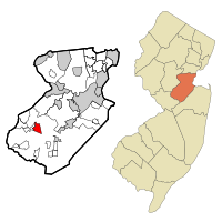
Pemberton Heights is an unincorporated community and census-designated place (CDP) located within Pemberton Township, in Burlington County, in the U.S. state of New Jersey. As of the 2010 United States Census, the CDP's population was 2,423.

<span class="mw-page-title-main">Presidential Lakes Estates, New Jersey</span> Populated place in Burlington County, New Jersey, US

Presidential Lakes Estates is an unincorporated community and census-designated place (CDP) located within Pemberton Township, in Burlington County, in the U.S. state of New Jersey. As of the 2010 United States Census, the CDP's population was 2,365.

<span class="mw-page-title-main">Princeton Junction, New Jersey</span> Populated place in Mercer County, New Jersey, US

Princeton Junction is an unincorporated community and census-designated place (CDP) located within West Windsor, in Mercer County, in the U.S. state of New Jersey. As of the 2010 United States Census, the CDP's population was 2,465.

<span class="mw-page-title-main">Cranbury (CDP), New Jersey</span> Populated place in Middlesex County, New Jersey, US

Cranbury is an unincorporated community and census-designated place (CDP) located within Cranbury Township, in Middlesex County, in the U.S. state of New Jersey. As of the 2010 United States Census, the CDP's population was 2,181. Despite the similarity in the name of Cranbury Township and the CDP, the two are not one and the same, as had been the case for most paired Township / CDP combinations prior to the 2010 Census, in which the CDP was coextensive with a township of the same name.

<span class="mw-page-title-main">Heathcote, New Jersey</span> Populated place in Middlesex County, New Jersey, US

Heathcote is an unincorporated community and census-designated place (CDP) located within South Brunswick, in Middlesex County, in the U.S. state of New Jersey. As of the 2010 United States Census, the CDP's population was 5,821.

<span class="mw-page-title-main">Kendall Park, New Jersey</span> Populated place in Middlesex County, New Jersey, US

Kendall Park is an unincorporated community and census-designated place (CDP) located within South Brunswick Township, in Middlesex County, in the U.S. state of New Jersey. As of the 2010 United States Census, the CDP's population was 9,339. Kendall Park has a post office with its own ZIP Code (08824) that encompasses the entire CDP, as well as some surrounding areas.

<span class="mw-page-title-main">Kingston, New Jersey</span> Populated place in Middlesex and Somerset counties, New Jersey, US

Kingston is an unincorporated community and census designated place (CDP) along the border of South Brunswick Township in Middlesex County and Franklin Township in Somerset County, and also located relatively near Princeton in Mercer County in the U.S. state of New Jersey. The historic settlement is in the Raritan Valley region, located along the course of the Millstone River. As of the 2010 United States Census, the CDP's population was 1,493, of which 1,222 were in South Brunswick Township and 271 in Franklin Township.

<span class="mw-page-title-main">Monmouth Junction, New Jersey</span> Populated place in Middlesex County, New Jersey, US

Monmouth Junction is an unincorporated community and census designated place (CDP) located within South Brunswick, in Middlesex County, in the U.S. state of New Jersey. As of the 2010 United States Census, the CDP's population was 2,887.

<span class="mw-page-title-main">Old Bridge (CDP), New Jersey</span> Populated place in Middlesex County, New Jersey, US

Old Bridge is a census-designated place (CDP) located in Old Bridge Township, in Middlesex County, in the U.S. state of New Jersey. As of the 2010 United States Census, the CDP's population was 23,753. Despite the similarity in the name of the CDP and the township, the two are not one and the same, as had been the case for most paired Township / CDP combinations prior to the 2010 Census, in which the CDP was coextensive with a township of the same name.

<span class="mw-page-title-main">Plainsboro Center, New Jersey</span> Populated place in Middlesex County, New Jersey, US

Plainsboro Center is an unincorporated community and census-designated place (CDP) located within Plainsboro Township, situated in southern Middlesex County, within the U.S. state of New Jersey. As of the 2020 United States census, the CDP's population was 2,760, its highest decennial count ever and an increase of 48 (+1.8%) from the 2,712 recorded at the 2010 census, which in turn reflected an increase of 503 (+22.8%) from the 2,209 counted in the 2000 census.

<span class="mw-page-title-main">Society Hill, Middlesex County, New Jersey</span> Populated place in Middlesex County, New Jersey, US

Society Hill is an unincorporated community and census-designated place (CDP) located within Piscataway Township, in Middlesex County, in the U.S. state of New Jersey. As of the 2010 United States Census, the CDP's population was 3,829.

<span class="mw-page-title-main">Fairview, Monmouth County, New Jersey</span> Populated place in Monmouth County, New Jersey, US

Fairview is an unincorporated community and census-designated place (CDP) located within Middletown Township, in Monmouth County, in the U.S. state of New Jersey. As of the 2010 United States Census, the CDP's population was 3,806.

<span class="mw-page-title-main">West Belmar, New Jersey</span> Populated place in Monmouth County, New Jersey, US

West Belmar is an unincorporated community and census-designated place (CDP) within Wall Township, in Monmouth County, in the U.S. state of New Jersey. At the 2010 census, the CDP's population was 2,493.

<span class="mw-page-title-main">West Freehold, New Jersey</span> Census-designated place in New Jersey, United States

West Freehold is an unincorporated community and census-designated place (CDP) within Freehold Township, in Monmouth County, New Jersey, United States. As of the 2010 United States Census, the CDP's population was 13,613. Due to the community's close proximity to the Battle of Monmouth, West Freehold is home to several important historical structures, which have been preserved in the 'West Freehold Village Historic District'. The historically preserved Monmouth Battlefield, along with the historic villages of Clarksburg, Englishtown, Smithburg and Tennent are a short distance away.

<span class="mw-page-title-main">Barnegat (CDP), New Jersey</span> Populated place in Ocean County, New Jersey, US

Barnegat is an unincorporated community and census-designated place (CDP) located within Barnegat Township, in Ocean County, in the U.S. state of New Jersey. As of the 2010 United States census, the CDP's population was 2,817.

<span class="mw-page-title-main">Cedar Glen Lakes, New Jersey</span> Populated place in Ocean County, New Jersey, US

Cedar Glen Lakes is an unincorporated community and census-designated place (CDP) located within Manchester Township, in Ocean County, in the U.S. state of New Jersey. As of the 2010 United States Census, the CDP's population was 1,421.

<span class="mw-page-title-main">Crestwood Village, New Jersey</span> CDP in Ocean County, New Jersey, US

Crestwood Village is an unincorporated community and census-designated place (CDP) located within Manchester Township, in Ocean County, in the U.S. state of New Jersey. As of the 2010 United States Census, the CDP's population was 7,907.

<span class="mw-page-title-main">Holiday Heights, New Jersey</span> Populated place in Ocean County, New Jersey, US

Holiday Heights is an unincorporated community and census-designated place (CDP) located within Berkeley Township, in Ocean County, in the U.S. state of New Jersey. As of the 2010 United States Census, the CDP's population was 2,099.

<span class="mw-page-title-main">Leisure Knoll, New Jersey</span> Populated place in Ocean County, New Jersey, US

Leisure Knoll is an unincorporated community and census-designated place (CDP) located within Manchester Township, in Ocean County, in the U.S. state of New Jersey. As of the 2010 United States Census, the CDP's population was 2,490.

<span class="mw-page-title-main">Crandon Lakes, New Jersey</span> Populated place in Sussex County, New Jersey, US

Crandon Lakes is an unincorporated community and census-designated place (CDP) split between Hampton Township and Stillwater Township, in Sussex County, in the U.S. state of New Jersey. As of the 2010 United States Census, the CDP's population was 1,178, of which 682 were in Hampton Township and 496 in Stillwater Township.

References

  1. "ArcGIS REST Services Directory". United States Census Bureau. Retrieved October 11, 2022.
  2. U.S. Geological Survey Geographic Names Information System: Dayton Census Designated Place, Geographic Names Information System. Accessed November 29, 2012.
  3. 1 2 QuickFacts Dayton CDP, New Jersey, United States Census Bureau. Accessed June 19, 2023.
  4. 1 2 Look Up a ZIP Code for Dayton, NJ, United States Postal Service. Accessed November 29, 2012.
  5. 1 2 3 Gazetteer of New Jersey Places, United States Census Bureau. Accessed July 21, 2016.
  6. 1 2 U.S. Census website, United States Census Bureau. Accessed September 4, 2014.
  7. Geographic Codes Lookup for New Jersey, Missouri Census Data Center. Accessed June 9, 2023.
  8. US Board on Geographic Names, United States Geological Survey. Accessed September 4, 2014.
  9. State of New Jersey Census Designated Places - BVP20 - Data as of January 1, 2020, United States Census Bureau. Accessed December 1, 2022.
  10. 1 2 New Jersey: 2010 - Population and Housing Unit Counts - 2010 Census of Population and Housing (CPH-2-32), United States Census Bureau, August 2012. Accessed November 29, 2012.
  11. GCT-PH1 - Population, Housing Units, Area, and Density: 2010 - County -- County Subdivision and Place from the 2010 Census Summary File 1 for Middlesex County, New Jersey Archived 2020-02-12 at archive.today , United States Census Bureau. Accessed November 29, 2012.
  12. 1 2 3 4 5 DP-1 - Profile of General Population and Housing Characteristics: 2010 Demographic Profile Data for Dayton CDP, New Jersey Archived 2020-02-12 at archive.today , United States Census Bureau. Accessed November 29, 2012.
  13. 1 2 History, Township of South Brunswick. Accessed November 21, 2019. "In 1866, the name was changed from Cross Roads to Dayton, in honor of William L. Dayton, an attorney for the Freehold and Jamesburg Agricultural Railroad. Dayton had helped settle disputes arising from the location of a railroad right-of-way. He was later a U.S. Senator, Vice Presidential nominee, and Minister to France."
  14. 1 2 Clayton, W. Woodford. History of Union and Middlesex Counties, New Jersey; With Biographical Sketches of Many of Their Pioneers and Prominent Men, p. 789. Everts and Peck, 1885. Accessed November 21, 2019. "Dayton, formerly known as Cross-Roads,is situated about a quarter of a mile from the New York Division of the Pennsylvania Railroad, southeast of the centre of the township, at the intersection of the Kingston road, the Plainsboro' road, and the Rhode Hall road with the New Brunswick and Cranbury turnpike, and was named in honor of William L. Dayton, of Trenton, the change having been necessitated by the frequent miscarriage of mails intended for that locality, there being another post-office in the State called Cross-Roads."
  15. Federal Writers' Project (1938). The Ocean Highway: New Brunswick, New Jersey to Jacksonville, Florida. American guide series. Works Progress Administration. p. 1.
  16. US Gazetteer files: 2010, 2000, and 1990, United States Census Bureau. Accessed September 4, 2014.
  17. 1 2 3 4 5 DP-1 - Profile of General Demographic Characteristics: 2000 from the Census 2000 Summary File 1 (SF 1) 100-Percent Data for Dayton CDP, New Jersey Archived 2020-02-12 at archive.today , United States Census Bureau. Accessed November 29, 2012.
  18. Asian Indian Communities Archived June 15, 2012, at the Wayback Machine , EPodunk. Accessed June 28, 2006.
  19. Contact Us, 2(X)IST.
  20. SGS EHS Locations in North America, SGS. Accessed March 18, 2022.
  21. 1 2 "Corporate Offices - Aurobindo Pharma USA".
  22. GMB North America Inc. NJ, GMB. Accessed March 18, 2022.
  23. US Headquarters, Haddad Brands. Accessed March 18, 2022.
  24. Morris, Tim. "Moran running 10K at U.S. Olympic Trials", Sentinel, June 26, 2008. Accessed October 11, 2018. "The gold medal rests next to his bed as a reminder. 'On days I don't want to run, I look at it,' said Ed Moran, the native of the Dayton section of South Brunswick who won the 5,000-meter run at last year's Pan-American Games in Rio de Janeiro Brazil."
  25. Sydney Schneider, UNC Wilmington Seahawks. Accessed October 11, 2018. "High School: South Brunswick; Hometown: Dayton, N.J."