
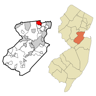
Middlesex County is located in central New Jersey, United States, extending inland from the Raritan Valley region to the northern portion of the Jersey Shore. As of the 2020 United States census, the county was the state's third-most populous county with a population of 863,162, its highest decennial count ever and an increase of 53,304 (+6.6%) from the 2010 census count of 809,858, which in turn reflected an increase of 59,696 (8.0%) from the 750,162 counted in the 2000 census. Middlesex is part of the New York metropolitan area. Many communities within the county serve as commuter towns to and from New York City and other points north.

Rio Grande is an unincorporated community and census-designated place (CDP) located within Middle Township and Lower Township in Cape May County, in the U.S. state of New Jersey.

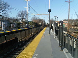
Princeton Junction is an unincorporated community and census-designated place (CDP) located within West Windsor, in Mercer County, in the U.S. state of New Jersey. As of the 2010 United States Census, the CDP's population was 2,465.
Avenel is an unincorporated community and census-designated place (CDP) located within Woodbridge Township, in Middlesex County, in the U.S. state of New Jersey. Avenel is approximately 25 miles (40 km) southwest of Midtown Manhattan along the North Jersey Coast rail line
Colonia is an unincorporated community and census-designated place (CDP) located within Woodbridge Township, in Middlesex County, in the U.S. state of New Jersey. As of the 2010 United States Census, the CDP's population was 17,795.

Fords is an unincorporated community and census-designated place (CDP) located within Woodbridge Township, in Middlesex County, in the U.S. state of New Jersey. As of the 2010 United States Census, the CDP's population was 15,187.

Iselin is an unincorporated community and census-designated place (CDP) located within Woodbridge Township, in Middlesex County, in the U.S. state of New Jersey. As of the 2010 United States census, Iselin's population was 18,695.

Monroe Township is a township located in southern Middlesex County, in the U.S. state of New Jersey. The township is centrally located within the Raritan Valley region and is an outer-ring suburb of New York City within the New York metropolitan area. As of the 2020 United States census, the township's population was 48,594, its highest decennial count ever and an increase of 9,462 (+24.2%) from the 39,132 recorded at the 2010 census, which in turn had reflected an increase of 11,133 (+39.8%) from the 27,999 from the 27,999 counted at the 2000 census. Monroe Township also comprises the largest land area of any municipality in Middlesex County, at approximately 42 square miles (110 km2).

Perth Amboy is a city in Middlesex County, in the U.S. state of New Jersey. Perth Amboy is part of the New York metropolitan area. As of the 2020 United States census, the city's population was 55,436, an increase of 4,622 (+9.1%) from the 2010 census count of 50,814, which in turn reflected an increase of 3,511 (+7.4%) from the 47,303 counted in the 2000 census. Perth Amboy has a Hispanic majority population. In the 2010 census, the Hispanic population made up 78.1% of the population, the second-highest in the state, behind Union City at 84.7%. Perth Amboy is known as the "City by the Bay", referring to its location adjoining Raritan Bay. The Census Bureau's Population Estimates Program calculated that the city's population was 55,357 in 2021, ranking the city as the 725th-most-populous in the country.

Port Reading is an unincorporated community and census-designated place (CDP) located within Woodbridge Township, in Middlesex County, in the U.S. state of New Jersey. As of the 2010 U.S. census, Port Reading's population was 3,728.

Sayreville is a borough in Middlesex County, in the U.S. state of New Jersey. Sayreville is within the heart of the Raritan Valley region, located on the south banks of the Raritan River, and also located on the Raritan Bay. As of the 2020 United States census, the borough's population was 45,345, an increase of 2,641 (+6.2%) from the 2010 census count of 42,704, which in turn reflected an increase of 2,327 (+5.8%) from the 40,377 counted in the 2000 census.

Sewaren is an unincorporated community and census-designated place (CDP) within Woodbridge Township, in Middlesex County, in the U.S. state of New Jersey. As of the 2010 United States Census, the CDP's population was 2,756.
South Amboy is a suburban city in Middlesex County, in the U.S. state of New Jersey, located on Raritan Bay. As of the 2020 United States census, the city's population was 9,411, an increase of 780 (+9.0%) from the 2010 census count of 8,631, which in turn reflected an increase of 718 (+9.1%) from the 7,913 counted in the 2000 census.

Woodbridge is an unincorporated community and census-designated place (CDP) within Woodbridge Township, in Middlesex County, in the U.S. state of New Jersey. As of the 2010 United States Census, the CDP's population was 19,265. Despite the similarity in the name of the CDP and the township, the two are not coextensive; the CDP occupies 15.7% of the township's 24.51 square miles (63.5 km2).

Woodbridge Township is a township in northern Middlesex County, in the U.S. state of New Jersey. The township is a regional hub of transportation and commerce for central New Jersey and a major bedroom suburb of New York City, within the New York metropolitan area. Located within the core of the Raritan Valley region, Woodbridge Township hosts the junction of the New Jersey Turnpike and the Garden State Parkway, the two busiest highways in the state, and also serves as the headquarters for the New Jersey Turnpike Authority, which operates both highways.
Menlo Park Terrace is an unincorporated community and census-designated place (CDP) and census-designated place located within Woodbridge Township in Middlesex County, in the U.S. state of New Jersey. It is located off U.S. Route 1 in between Menlo Park Mall and Woodbridge Center at Exit 130 of the Garden State Parkway.
Hopelawn is an unincorporated community and census-designated place (CDP) located within Woodbridge Township in Middlesex County, in the U.S. state of New Jersey.
The Middlesex County Magnet Schools, formerly known as the Middlesex County Vocational and Technical Schools, is a public school district that provides a network of high schools serving the vocational and technical education needs of students in Middlesex County, New Jersey, United States. The district was the first county vocational school system in the United States. The district serves high school, adult, and special needs students.
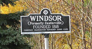
Windsor is a small historic unincorporated community and census-designated place (CDP) located within Robbinsville Township in Mercer County, in the U.S. state of New Jersey. The area is served as United States Postal Service ZIP Code 08561. As of the 2020 United States census, the CDP's population was 330, an increase of 104 (+46.0%) above the 226 counted at the 2010 census. The community, covering 570 acres (230 ha), was added to the National Register of Historic Places in 1992.


