Route 18 is a 42.8-mile-long (68.9 km) state highway in the central part of the US state of New Jersey. It begins at an intersection with Route 138 in Wall Township, Monmouth County and ends at Interstate 287 (I-287) in Piscataway Township, Middlesex County. Route 18 is a major route through central New Jersey that connects the Jersey Shore to the Raritan Valley region, connecting the county seats of Monmouth (Freehold) and Middlesex respectively. The route runs through Ocean Township, Marlboro Township, and East Brunswick, as for much of the route is a limited-access freeway. The remainder of the route is a multi-lane divided highway with traffic lights in the East Brunswick and Old Bridge areas. Route 18 was designated in 1939 as a proposed freeway from Old Bridge to Eatontown. The section west of Old Bridge was formerly designated as part Route S28, a prefixed spur of State Highway Route 28 from Middlesex to Matawan. The designation, assigned in the 1927 renumbering, remained until a second renumbering in 1953. At that point, Route S28 was redesignated as Route 18, though the section from Old Bridge to Matawan was signed as TEMP 18, as this section would be decommissioned when the Route 18 freeway was built.

Route 29 is a state highway in the U.S. state of New Jersey. Signed north-south, it runs 34.76 mi (55.94 km) from an interchange with Interstate 295 (I-295) in Hamilton Township in Mercer County, where it continues as I-195, northwest to Route 12 in Frenchtown, Hunterdon County. Between the southern terminus and I-295 in Ewing Township, the route is a mix of freeway and four-lane divided highway that runs along the Delaware River through Trenton. This section includes a truck-restricted tunnel that was built along the river near historic houses and Riverview Cemetery. North of I-295, Route 29 turns into a scenic and mostly two-lane highway. North of the South Trenton Tunnel, it is designated the Delaware River Scenic Byway, a New Jersey Scenic Byway and National Scenic Byway, that follows the Delaware River in mostly rural sections of Mercer County and Hunterdon County. The obsolete Delaware & Raritan Canal usually stands between the river and the highway. Most sections of this portion of Route 29 are completely shaded due to the tree canopy. Route 29 also has a spur, Route 129, which connects Route 29 to U.S. Route 1 (US 1) in Trenton.

Piscataway is a township in Middlesex County, in the U.S. state of New Jersey. It is a suburb of the New York metropolitan area, in the Raritan Valley. As of the 2020 United States census, the township's population was 60,804, an increase of 4,760 (+8.5%) from the 2010 census count of 56,044, which in turn reflected an increase of 5,562 (+11.0%) from 50,482 at the 2000 census.

Franklin Township is a township in Somerset County, in the U.S. state of New Jersey. It is centrally located in the Raritan Valley region, within the New York Metropolitan Area. As of the 2020 United States census, the township's population was 68,364, an increase of 6,064 (+9.7%) from the 2010 census count of 62,300, which in turn reflected an increase of 11,397 (+22.4%) from the 50,903 counted in the 2000 census. The township was the state's 19th most-populous municipality in 2020, after being ranked 22nd in 2010.

Raritan River is a major river of New Jersey. Its watershed drains much of the mountainous area of the central part of the state, emptying into the Raritan Bay on the Atlantic Ocean.

The Delaware and Raritan Canal is a canal in central New Jersey, built in the 1830s, that connects the Delaware River to the Raritan River. It was an efficient and reliable means of transportation of freight between Philadelphia and New York City, transporting anthracite coal from eastern Pennsylvania during much of the 19th and early 20th centuries. The canal allowed shippers to cut many miles off the existing route from the Pennsylvania Coal Region down the Delaware, around Cape May, and up the occasionally treacherous Atlantic Ocean coast to New York City.
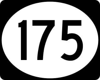
Route 175 is a short, 2.95-mile (4.75 km) long state highway in Mercer County, New Jersey, United States. The route runs along a former alignment of New Jersey Route 29 before the construction of the John Fitch Parkway in the 1960s. The route begins at Route 29 in the capital city of Trenton, running along Sanhican Road, River Road and West Upper Ferry Road into Ewing Township. The route serves primarily as a frontage road for Route 29. The northernmost portion of Route 175 is parallel to the Delaware and Raritan Canal until coming to an end at a merge with Route 29 in Ewing Township.

Titusville is an unincorporated community located within Hopewell Township in Mercer County, New Jersey, United States. The area includes a post office with its own ZIP code (08560), several restaurants, gas stations, a firehouse, and a small cluster of homes. The Washington Crossing State Park, dedicated to George Washington's crossing of the Delaware River in 1776, is adjacent to the community.

The Millstone River is a 38.6-mile-long (62.1 km) tributary of the Raritan River in central New Jersey in the United States.
Six Mile Run is an unincorporated community and census-designated place (CDP) located in Franklin Township, in Somerset County, New Jersey, United States. As of the 2010 United States Census, the CDP's population was 3,184.

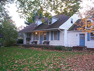
The Metlar House, also known as the Knapp House, the Bodine House, or the Metlar–Bodine House, is an historic house, now museum, located along River Road in Piscataway, New Jersey. It is also believed to be haunted. In 2003 a fire badly damaged the house. The museum has undergone major renovations over the past decade and, as of Summer 2014, is once again open to the public.

Raritan Landing is a historical unincorporated community located within Piscataway Township in Middlesex County, New Jersey, United States, which was once an inland port, the farthest upstream point ocean-going ships could reach along the Raritan River, across from New Brunswick. Begun in the early 18th century it remained vital until the mid 19th century, when most of the port was abandoned.

The Blackwells Mills Canal House is located at Blackwells Mills Road and Canal Road in Franklin Township, Somerset County, New Jersey, United States, on the Delaware and Raritan Canal. Across the canal is Blackwells Mills, New Jersey.
The Van Wickle House, also known as the Symen Van Wickle House, is a historical house located at 1289 Easton Avenue in the Somerset section of Franklin Township, Somerset County, New Jersey, United States. It was built in 1722 by Symen Van Wickle, also known as Symen Van Wicklin. The house, historically known as The Meadows, was added to the National Register of Historic Places on December 4, 1973.

Landing Lane Bridge is part of County Route 609 and spans the Raritan River and the Delaware and Raritan Canal in New Jersey. The two lane bridge connects Piscataway to the north with New Brunswick to the south. The approaching roadways on both sides are known as "Landing Lane." The Delaware and Raritan Canal State Park and towpath is accessible from the bridge.

U.S. Route 202 (US 202) is a U.S. Highway running from New Castle, Delaware northeast to Bangor, Maine. In the U.S. state of New Jersey, the route runs 80.31 mi (129.25 km) from the New Hope–Lambertville Toll Bridge over the Delaware River at the Pennsylvania border in Delaware Township, Hunterdon County near Lambertville northeast to the New York border in Mahwah, Bergen County. Along the route's journey, it passes through a variety of suburban and rural environments, including the communities of Flemington, Somerville, Morristown, Parsippany-Troy Hills, Wayne, and Oakland as well as five counties: Hunterdon, Somerset, Morris, Passaic, and Bergen. US 202 encounters many major roads in New Jersey, including Route 31, US 206, US 22, Interstate 80 (I-80), US 46, Route 23, and Route 17. From Somerville to the New York border, US 202 generally runs within a close distance of I-287 and interchanges with that route several times. The road ranges from a four-lane freeway between Lambertville and Ringoes in Hunterdon County to a two-lane undivided road through much of the northern portion of the route. North of the Route 53 intersection in Morris Plains, US 202 is maintained by individual counties rather than the New Jersey Department of Transportation with a few exceptions.

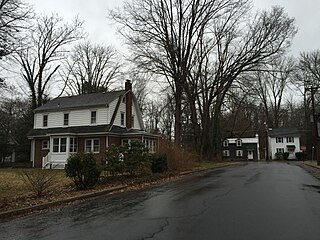
The Road Up Raritan Historic District is a 69-acre (28 ha) historic district located along River Road in the township of Piscataway in Middlesex County, New Jersey. It is north of Raritan Landing, once an important inland port on the Raritan River during the 18th and 19th centuries. The name is taken from an earlier colonial era name for what was once a Lenape path, Assunpink Trail that became a main road parallel to the river. Piscataway Township itself was formed on December 18, 1666 as one of the first seven townships in East Jersey, and is one of the oldest municipalities in the state. It was added to the National Register of Historic Places on September 18, 1997, for its significance in architecture, military history, and exploration/settlement. The district includes nine of fourteen historic homes along an approximately 1.2-mile (1.9 km) stretch of River Road. The Metlar-Bodine House and the Cornelius Low House are also in the immediate vicinity.
Wilburtha is a section of Ewing Township in Mercer County, New Jersey, United States. Located where Wilburtha Road crosses the Delaware and Raritan Canal, it is one of the oldest settlements in Ewing Township and developed due to the construction of the canal in the early 19th century. The community was known as Greensburg before adopting its current name in 1883. The Yardley–Wilburtha Bridge once connected Wilburtha to Yardley, Pennsylvania on the other side of the Delaware River. The Belvidere Delaware Railroad once passed through the village. Today, Wilburtha is primarily a residential neighborhood consisting of detached, single-family homes, the majority of which were built in the 1950s through the early 1980s. There are still many Georgian and Federal-style homes found in the area.
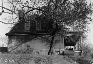
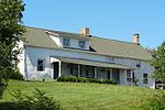
Ross Hall was a historic colonial farmhouse located on River Road in Piscataway, New Jersey. It was built c. 1739 by Edward Antill and is also known as the Edward Antill House. In 1768, it was purchased by its namesake, Dr. Alexander Ross.

Piscatawaytown is the oldest neighborhood in Edison Township in Middlesex County, New Jersey. It was established in the 1660s as the original village in what was then within Piscataway Township. Piscatawaytown is centered around St. James Church and the Piscatawaytown Common, near the intersection of Plainfield and Woodbridge Avenues. The Piscatawaytown Burial Ground is one of the oldest recorded cemeteries in Middlesex County and maintained by the township.