Presidential Lakes Estates is an unincorporated community and census-designated place (CDP) located within Pemberton Township, in Burlington County, New Jersey, United States. As of the 2010 United States Census, the CDP's population was 2,365.

Ramblewood is an unincorporated community and census-designated place (CDP) located within Mount Laurel Township in Burlington County, New Jersey, United States. As of the 2010 United States Census, the CDP's population was 5,907.

Golden Triangle is an unincorporated community and census-designated place (CDP) located within Cherry Hill Township, in Camden County, New Jersey, United States. As of the 2010 United States Census, the CDP's population was 4,145.

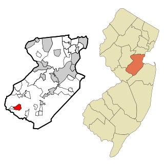
Concordia is an unincorporated community and census-designated place (CDP) located within Monroe Township, in Middlesex County, New Jersey, United States. The CDP is oriented around the age restricted gated community of Concordia. As of the 2010 United States Census, the CDP's population was 3,092.

Cranbury is an unincorporated community and census-designated place (CDP) located within Cranbury Township, in Middlesex County, New Jersey, United States. As of the 2010 United States Census, the CDP's population was 2,181. Despite the similarity in the name of Cranbury Township and the CDP, the two are not one and the same, as had been the case for most paired Township / CDP combinations prior to the 2010 Census, in which the CDP was coextensive with a township of the same name.

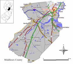
Fords is an unincorporated community and census-designated place (CDP) located within Woodbridge Township, in Middlesex County, New Jersey, United States. As of the 2010 United States Census, the CDP's population was 15,187.

Heathcote is an unincorporated community and census-designated place (CDP) located within South Brunswick Township, in Middlesex County, New Jersey, United States. As of the 2010 United States Census, the CDP's population was 5,821.

Old Bridge is a census-designated place (CDP) in Old Bridge Township, in Middlesex County, New Jersey, United States. As of the 2010 United States Census, the CDP's population was 23,753. Despite the similarity in the name of the CDP and the township, the two are not one and the same, as had been the case for most paired Township / CDP combinations prior to the 2010 Census, in which the CDP was coextensive with a township of the same name.

Port Reading is a census-designated place and unincorporated community located within Woodbridge Township, in Middlesex County, New Jersey, United States. As of the 2010 United States Census, the CDP's population was 3,728.
Princeton Meadows is an unincorporated community and census-designated place (CDP) located within Plainsboro Township, in Middlesex County, New Jersey, United States. As of the 2010 United States Census, the CDP's population was 13,834.

Sewaren is an unincorporated community and census-designated place (CDP) within Woodbridge Township, in Middlesex County, New Jersey, United States. As of the 2010 United States Census, the CDP's population was 2,756.

Whittingham, also known as Greenbriar at Whittingham, is an unincorporated community and census-designated place (CDP) located within Monroe Township, in Middlesex County, New Jersey, United States. As of the 2010 United States Census, the CDP's population was 2,476. The area is focused around the age-restricted gated community of Whittingham.

East Freehold is an unincorporated community and census-designated place (CDP) located within Freehold Township, in Monmouth County, New Jersey, United States. As of the 2010 United States Census, the CDP's population was 4,894.

Fairview is an unincorporated community and census-designated place (CDP) located within Middletown Township, in Monmouth County, New Jersey, United States. As of the 2010 United States Census, the CDP's population was 3,806.

West Belmar is an unincorporated community and census-designated place (CDP) within Wall Township, in Monmouth County, New Jersey, United States. At the 2010 census, the CDP's population was 2,493.

Allenwood is an unincorporated community and census-designated place (CDP) located within Wall Township, in Monmouth County, New Jersey, United States. As of the 2010 United States Census, the CDP's population was 925.

Yorketown is an unincorporated community and census-designated place (CDP) within Manalapan Township, in Monmouth County, New Jersey, United States. At the 2020 census, the CDP's population was 6,739.

Barnegat is an unincorporated community and census-designated place (CDP) located within Barnegat Township, in Ocean County, New Jersey, United States. As of the 2010 United States Census, the CDP's population was 2,817.

Cedar Glen Lakes is an unincorporated community and census-designated place (CDP) located within Manchester Township, in Ocean County, New Jersey, United States. As of the 2010 United States Census, the CDP's population was 1,421.

Holiday Heights is an unincorporated community and census-designated place (CDP) located within Berkeley Township, in Ocean County, New Jersey, United States. As of the 2010 United States Census, the CDP's population was 2,099.