Rhodell, West Virginia

Last updated

Rhodell, West Virginia
Rhodell, West Virginia (2014).jpg
County Route 33 in Rhodell
Raleigh County West Virginia Incorporated and Unincorporated areas Rhodell Highlighted.svg
Location of Rhodell in Raleigh County, West Virginia.
Coordinates: 37°36′29″N81°18′14″W / 37.60806°N 81.30389°W / 37.60806; -81.30389
Country United States
State West Virginia
County Raleigh
Area
[1]
  Total0.31 sq mi (0.81 km2)
  Land0.31 sq mi (0.81 km2)
  Water0.00 sq mi (0.00 km2)
Elevation
1,627 ft (496 m)
Population
 (2010) [2]
  Total173
  Estimate 
(2019) [3]
160
  Density509.55/sq mi (197.02/km2)
Time zone UTC-5 (Eastern (EST))
  Summer (DST) UTC-4 (EDT)
ZIP code
25915
Area code 304
FIPS code 54-67996 [4]
GNIS feature ID1545524 [5]

Rhodell is an unincorporated community in Raleigh County, West Virginia, United States. The population was 173 at the 2010 census.

Contents

History

It was incorporated in 1937 as a town, but on June 13, 2017, Rhodell residents voted 33–13 to dissolve the town. The town reverted to an unincorporated portion of Raleigh County on July 1, 2017. [6]

Geography

According to the United States Census Bureau, the town has a total area of 0.31 square miles (0.80 km2), all land. [7]

Demographics

Historical population
CensusPop.Note
1940 995
1950 829−16.7%
1960 626−24.5%
1970 500−20.1%
1980 472−5.6%
1990 221−53.2%
2000 2345.9%
2010 173−26.1%
2019 (est.)160 [3] −7.5%
U.S. Decennial Census [8]
Rhodell in 1974 Rhodell, West Virginia 1974.jpg
Rhodell in 1974

2010 census

As of the census [2] of 2010, there were 173 people, 71 households, and 45 families living in the town. The population density was 558.1 inhabitants per square mile (215.5/km2). There were 95 housing units at an average density of 306.5 per square mile (118.3/km2). The racial makeup of the town was 97.1% White, 2.3% African American, and 0.6% from two or more races.

There were 71 households, of which 32.4% had children under the age of 18 living with them, 53.5% were married couples living together, 4.2% had a female householder with no husband present, 5.6% had a male householder with no wife present, and 36.6% were non-families. 29.6% of all households were made up of individuals, and 11.2% had someone living alone who was 65 years of age or older. The average household size was 2.44 and the average family size was 3.11.

The median age in the town was 38.9 years. 22% of residents were under the age of 18; 10.5% were between the ages of 18 and 24; 26% were from 25 to 44; 28.3% were from 45 to 64; and 13.3% were 65 years of age or older. The gender makeup of the town was 50.9% male and 49.1% female.

2000 census

As of the census [4] of 2000, there were 234 people, 93 households, and 66 families living in the town. The population density was 749.6 inhabitants per square mile (291.4/km2). There were 111 housing units at an average density of 355.6 per square mile (138.2/km2). The racial makeup of the town was 97.44% White, 1.28% African American, 0.43% from other races, and 0.85% from two or more races. Hispanic or Latino of any race were 1.28% of the population.

There were 93 households, out of which 29.0% had children under the age of 18 living with them, 58.1% were married couples living together, 8.6% had a female householder with no husband present, and 29.0% were non-families. 26.9% of all households were made up of individuals, and 12.9% had someone living alone who was 65 years of age or older. The average household size was 2.52 and the average family size was 3.02.

In the town, the population was spread out, with 28.2% under the age of 18, 6.8% from 18 to 24, 31.2% from 25 to 44, 23.5% from 45 to 64, and 10.3% who were 65 years of age or older. The median age was 32 years. For every 100 females, there were 98.3 males. For every 100 females age 18 and over, there were 88.8 males.

The median income for a household in the town was $17,143, and the median income for a family was $19,167. Males had a median income of $17,750 versus $18,750 for females. The per capita income for the town was $7,582. About 34.5% of families and 40.7% of the population were below the poverty line, including 61.0% of those under the age of eighteen and 28.6% of those 65 or over.

Rhodell, West Virginia - panorama.jpg
Coal City Road in Rhodell

Related Research Articles

<span class="mw-page-title-main">Bancroft, Maine</span> Unorganized territory in Maine, United States

Bancroft is a township in Aroostook County, Maine, United States. The population was 57 at the 2020 census. On July 1, 2015 the town voted to deorganize and become part of the unorganized territory of South Aroostook.

<span class="mw-page-title-main">Littleton, Maine</span> Town in the state of Maine, United States

Littleton is a town in Aroostook County, Maine, United States. The population was 997 at the 2020 census.

<span class="mw-page-title-main">St. Francis, Maine</span> Town in the state of Maine, United States

St. Francis is a town in Aroostook County, Maine, United States on the Canada–United States border at the junction of the St. Francis River and the Saint John River. The population was 438 at the 2020 census. First settled by English speakers from southern Maine, the original population has been supplanted by French-speaking Acadians.

<span class="mw-page-title-main">Wade, Maine</span> Town in the state of Maine, United States

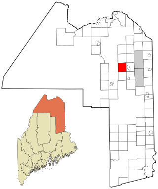
Wade is a town in Aroostook County, Maine, United States. The population was 229 at the 2020 census.

<span class="mw-page-title-main">Westfield, Maine</span> Town in the state of Maine, United States

Westfield is a town in Aroostook County, Maine, United States. The population was 455 at the 2020 census.

<span class="mw-page-title-main">Weston, Maine</span> Town in the state of Maine, United States

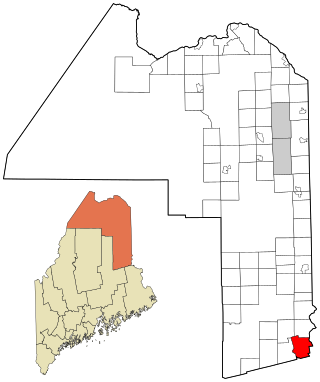
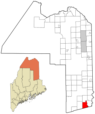
Weston is a town in Aroostook County, Maine, United States. The population was 245 at the 2020 census.

<span class="mw-page-title-main">Chesterville, Maine</span> Town in Maine, United States

Chesterville is a town in Franklin County, Maine, United States. The population was 1,328 at the 2020 census.

<span class="mw-page-title-main">Penobscot, Maine</span> Town in the state of Maine, United States

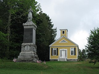
Penobscot is a town in Hancock County, Maine, United States. The Bagaduce River flows through the town. The population was 1,136 at the 2020 census.

Kenduskeag is a town in Penobscot County, Maine, United States. The population was 1,346 at the 2020 census.

LaGrange is a town in Penobscot County, Maine, United States. The population was 635 at the 2020 census.

Lee is a town in Penobscot County, Maine, United States. It was incorporated in 1832. The town was originally called Mattekeunk, but changed it to Lee to give it an English name. Stephen Lee suggested the town be named Lee after Revolutionary general Henry "High Horse" Lee. To further convince the townsfolk, he brought a barrel of rum to the meeting. The population was 916 at the 2020 census. Lee has been home to Lee Academy since 1845.

Plymouth is a town in Penobscot County, Maine, United States. The population was 1,325 at the 2020 census.

<span class="mw-page-title-main">Smithfield, Maine</span> Town in the state of Maine, United States

Smithfield is a town in Somerset County, Maine, United States. The population was 925 at the 2020 census. The town was incorporated on February 29, 1840 making it the only town in Maine incorporated on Leap Day. The town was named after the Rev. Henry Smith, an early settler.

Charlotte is a town in Washington County, Maine, United States. The town was named for the wife of legislator William Vance. The population was 337 at the 2020 census.

<span class="mw-page-title-main">Dennysville, Maine</span> Town in the state of Maine, United States

Dennysville is a town in Washington County, Maine, United States. The population was 300 at the 2020 census.

Marshfield is a town in Washington County, Maine, United States. The population was 528 at the 2020 census.

Waite is a town in Washington County, Maine, United States. The town was named after Benjamin Waite, a lumberman. The population was 66 at the 2020 census.

<span class="mw-page-title-main">Worthington, West Virginia</span> Town in West Virginia, United States

Worthington is a town in Marion County, West Virginia, United States. The population was 158 at the 2010 census. Worthington was incorporated in 1893 and named for Colonel George Worthington, an early settler. U.S. Route 19 passes through the town.

<span class="mw-page-title-main">Gilbert, West Virginia</span> Town in West Virginia, United States

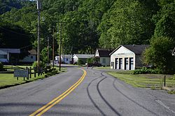
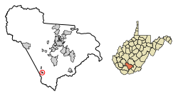
Gilbert is a town in Mingo County, West Virginia, United States, along the Guyandotte River. The population was 333 at the 2020 census. Gilbert was incorporated in 1918 and named for Gilbert Creek, which derives its name from the name of an early traveler in the area who was killed by Native Americans. Gilbert is known nationwide for the Hatfield-McCoy ATV Trails that are located in the area. There are a number of lodges and restaurants in Gilbert.

<span class="mw-page-title-main">Albright, West Virginia</span> Town in West Virginia, United States

Albright is a town in central Preston County, West Virginia, United States, along the Cheat River. The population was 260 at the 2020 census. A former coal town, it is part of the Morgantown metropolitan area.

References

  1. "2019 U.S. Gazetteer Files". United States Census Bureau. Retrieved August 7, 2020.
  2. 1 2 "U.S. Census website". United States Census Bureau . Retrieved January 24, 2013.
  3. 1 2 "Population and Housing Unit Estimates". United States Census Bureau. May 24, 2020. Retrieved May 27, 2020.
  4. 1 2 "U.S. Census website". United States Census Bureau . Retrieved January 31, 2008.
  5. "US Board on Geographic Names". United States Geological Survey. October 25, 2007. Retrieved January 31, 2008.
  6. "Voters in Rhodell Dissolve Town Charter". WVNS-TV. June 13, 2017. Retrieved June 13, 2017.
  7. "US Gazetteer files 2010". United States Census Bureau. Archived from the original on January 25, 2012. Retrieved January 24, 2013.
  8. "Census of Population and Housing". Census.gov. Retrieved June 4, 2015.