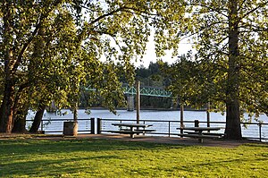
Milwaukie is a city mostly in Clackamas County, Oregon, United States; a very small portion of the city extends into Multnomah County. The population was 21,119 at the 2020 census. Founded in 1847 on the banks of the Willamette River, the city, known as the Dogwood City of the West, was incorporated in 1903 and is the birthplace of the Bing cherry. The city is now a suburb of Portland and also adjoins the unincorporated areas of Clackamas and Oak Grove.
Brooklyn is a mostly residential neighborhood in southeast Portland, Oregon. It sits along the east side of the Willamette River in the vicinity of Reed College. Founded as a neighborhood in the late 1860s, the neighborhood today is a middle-class area comprising mainly single family homes, interspersed with remaining industrial sites along the river and a large railyard. This railyard was home to Southern Pacific 4449 as well as several other large antique steam and diesel-electric locomotives.

Oregon Route 43 is an Oregon state highway that runs between the cities of Oregon City and Portland, mostly along the western flank of the Willamette River. While it is technically known by the Oregon Department of Transportation as the Oswego Highway No. 3, on maps it is referred to by its route number or by the various street names it has been given.

Oregon Route 99E is an Oregon state highway that runs between Junction City, Oregon and an interchange with I-5 just south of the Oregon/Washington border, in Portland. It, along with OR 99W, makes up a split of OR 99 in the northern part of the state. This split existed when the route was U.S. Route 99, when the two branches were U.S. 99W and U.S. 99E.

Cleveland High School (CHS) (formally Grover Cleveland High School) is a public high school in inner southeast Portland, Oregon, United States. It is part of the Portland Public Schools district. Its attendance boundary covers Ladd's Addition, Sellwood, Hosford-Abernethy, and Woodstock.

Ardenwald-Johnson Creek is a neighborhood straddling the border between Portland and Milwaukie, Oregon. It is recognized by both Portland's Office of Neighborhood Involvement as well as Milwaukie's Neighborhoods Program.
Westmoreland is one of two distinct districts making up the Sellwood-Moreland neighborhood of Southeast Portland, bordering Brooklyn to the north, the Willamette River to the west, Eastmoreland to the east, and Sellwood to the south. The isolation caused by being bounded on two sides by the river and Oregon Route 99E have produced a distinct small-town atmosphere, despite its being relatively close to downtown Portland.

Franklin High School (FHS) is a public high school in Portland, Oregon, United States. It is located in central southeast Portland in the South Tabor neighborhood. It is the largest high school in the Portland Public School District. Its attendance boundary is expansive, with six middle schools feeding into it and covering the neighborhoods of Southeast Portland, Mt. Tabor, Lents, and Belmont.

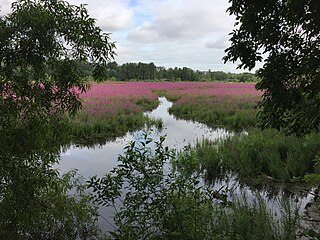
Johnson Creek is a 25-mile (40 km) tributary of the Willamette River in the Portland metropolitan area of the U.S. state of Oregon. Part of the drainage basin of the Columbia River, its catchment consists of 54 square miles (140 km2) of mostly urban land occupied by about 180,000 people as of 2012. Passing through the cities of Gresham, Portland, and Milwaukie, the creek flows generally west from the foothills of the Cascade Range through sediments deposited by glacial floods on a substrate of basalt. Though polluted, it is free-flowing along its main stem and provides habitat for salmon and other migrating fish.

The Springwater Corridor Trail is a bicycle and pedestrian rail trail in the Portland metropolitan area in Oregon, United States. It follows a former railway line from Boring through Gresham to Portland, where it ends south of the Eastbank Esplanade. Most of the corridor, about 21 miles (34 km) long, consists of paved, off-street trail, though about 1 mile (1.6 km) overlaps city streets in Portland's Sellwood neighborhood. A large segment roughly follows the course of Johnson Creek and crosses it on bridges many times. Much of the corridor was acquired by the City of Portland in 1990; remaining segments were acquired by Metro thereafter.
The 40-Mile Loop is a partially completed greenway trail around and through Portland in the U.S. state of Oregon. It was proposed in 1903 by the Olmsted Brothers architecture firm as part of the development of Forest Park. One greenway expert calls it "one of the most creative and resourceful greenway projects in the country."
John Sellwood was a pioneer Episcopal minister who settled in the U.S. state of Oregon on a 321-acre (130 ha) donation land claim on the east bank of the Willamette River upstream from Portland.
Oaks Bottom Wildlife Refuge is a city park of about 141 acres (57 ha) in southeast Portland, in the U.S. state of Oregon. Located in a floodplain along the east bank of the Willamette River near Sellwood, the park is known for attracting a wide variety of birds. In 1988, the park was named Portland's first wildlife refuge, and in 2004, it was designated the city's first migratory bird park.

Willamette Park is a city park of about 26 acres (11 ha) in south Portland, in the U.S. state of Oregon. Located at Southwest Macadam Avenue and Nebraska Street, the park includes a boat dock and ramp, paved and unpaved paths, picnic areas, restrooms, a dog off-leash area, playground, soccer field, and tennis courts.

Butterfly Park is a city park of about 1 acre (0.4 ha) in Portland, in the U.S. state of Oregon. Located at 7720 South Macadam Avenue, the park includes a natural area and walking paths near the Willamette River. The natural area provides important habitat for butterflies, including mourning cloaks and orange sulphurs.

Oaks Pioneer Church, formerly known as St. John's Episcopal Church, in southeast Portland in the U.S. state of Oregon is a non-denominational one-story chapel listed on the National Register of Historic Places. Built in 1851, it was added to the register in 1974. It is the oldest intact church building in Oregon.

The Sellwood–Moreland Library is a branch of the Multnomah County Library, in the Sellwood neighborhood of Portland in the U.S. state of Oregon. First established in 1905 as the Sellwood Reading Room, it operated in several Sellwood locations before re-opening in 2002 in a new mixed-use building at S.E. 13th Avenue and Bidwell Street.

Julius Caesar Moreland was an Oregon pioneer, a successful lawyer, and a judge based in Portland, Oregon. He was also Clerk of the Oregon Supreme Court in Salem in the early 20th century. He is the namesake of the Eastmoreland, Westmoreland, and Sellwood – Moreland neighborhoods.

Southeast Bybee Boulevard is a light rail station in Portland, Oregon, United States, served by TriMet as part of the MAX Light Rail system. It is the 14th station southbound on the Orange Line, which operates between Portland City Center, Southeast Portland, and Milwaukie. The grade-separated, island platform station adjoins Union Pacific Railroad (UP) freight tracks to the east and McLoughlin Boulevard to the west. Its entrances are located on the Bybee Bridge, which spans over the platform and connects Portland's Sellwood-Moreland and Eastmoreland neighborhoods. Nearby places of interest include Westmoreland Park, Eastmoreland Golf Course, Crystal Springs Rhododendron Garden, and Reed College.

Kay's Bar is a bar and restaurant in Portland, Oregon, United States.