
San Miguel County is a county located in the U.S. state of Colorado. As of the 2020 census, the population was 8,072. The county seat is Telluride. The county is named for the San Miguel River.

Ouray County is a county located in the U.S. state of Colorado. As of the 2020 census, the population was 4,874. The county seat is Ouray. Because of its rugged mountain topography, Ouray County is also known as the Switzerland of America.

Montrose County is a county located in the U.S. state of Colorado. As of the 2020 census, the population was 42,679. The county seat is Montrose, for which the county is named.

Gunnison County is a county located in the U.S. state of Colorado. As of the 2020 census, the population was 16,918. The county seat is Gunnison. The county was named for John W. Gunnison, a United States Army officer and captain in the Army Topographical Engineers, who surveyed for the transcontinental railroad in 1853.

Ouray is a home rule municipality that is the county seat of Ouray County, Colorado, United States. The city population was 1,000 as of the 2010 census. The Ouray Post Office has the ZIP Code 81427. Located at an elevation of 7,792 feet (2,375 m), Ouray's climate, natural alpine environment, and scenery have earned it the nickname "Switzerland of America".

The Town of Ridgway is the home rule municipality that is the most populous municipality in Ouray County, Colorado, United States. The town is a former railroad stop on the Uncompahgre River in the northern San Juan Mountains. The town population was 713 at the 2000 census and 924 according to the 2010 census.

Ouray was a Native American chief of the Tabeguache (Uncompahgre) band of the Ute tribe, then located in western Colorado. Because of his leadership ability, Ouray was acknowledged by the United States government as a chief of the Ute and he traveled to Washington, D.C. to negotiate for the welfare of the Utes. Raised in the culturally diverse town of Taos, Ouray learned to speak many languages that helped him in the negotiations, which were complicated by the manipulation of his grief over his five-year-old son abducted during attack by the Sioux and trantee. Ouray met with Presidents Lincoln, Grant, and Hayes and was called the man of peace because he sought to make treaties with settlers and the government.
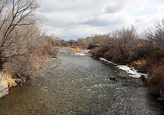
The Uncompahgre River is a tributary of the Gunnison River, approximately 75 mi (121 km) long, in southwestern Colorado in the United States. Lake Como at 12,215 ft (3723m) in northern San Juan County, in the Uncompahgre National Forest in the northwestern San Juan Mountains is the headwaters of the river. It flows northwest past Ouray, Ridgway, Montrose, and Olathe and joins the Gunnison at Confluence Park in Delta.

Uncompahgre Peak is the sixth highest summit of the Rocky Mountains of North America and the U.S. state of Colorado. The prominent 14,321-foot (4365.0 m) fourteener is the highest summit of the San Juan Mountains and the highest point in the drainage basin of the Colorado River and the Gulf of California. It is located in the Uncompahgre Wilderness in the northern San Juans, in northern Hinsdale County approximately 7 miles (11 km) west of the town of Lake City.

Ute are the Indigenous people of the Ute tribe and culture among the Indigenous peoples of the Great Basin. They had lived in sovereignty in the regions of present-day Utah and Colorado in the Southwestern United States for many centuries until European settlers seized their lands. The state of Utah is named after the Ute tribe.

Meeker Massacre, or Meeker Incident, White River War, Ute War, or the Ute Campaign), took place on September 29, 1879 in Colorado. Members of a band of Ute Indians attacked the Indian agency on their reservation, killing the Indian agent Nathan Meeker and his 10 male employees and taking five women and children as hostages. Meeker had been attempting to convert the Utes to Christianity, to make them farmers, and to prevent them from following their nomadic culture. On the same day as the massacre, United States Army forces were en route to the Agency from Fort Steele in Wyoming due to threats against Meeker. The Utes attacked U.S. troops led by Major Thomas T. Thornburgh at Milk Creek, 18 mi (29 km) north of present day Meeker, Colorado. They killed the major and 13 troops. Relief troops were called in and the Utes dispersed.

The Ute Indian Tribe of the Uinta and Ouray Reservation is a Federally Recognized Tribe of Indians in northeastern Utah, United States. Three bands of Utes comprise the Ute Indian Tribe: the Whiteriver Band, the Uncompahgre Band and the Uintah Band. The Tribe has a membership of more than three thousand individuals, with over half living on the Uintah and Ouray Indian Reservation. The Ute Indian Tribe operates its own tribal government and oversees approximately 1.3 million acres of trust land which contains significant oil and gas deposits.
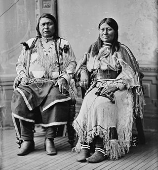
Chipeta or White Singing Bird was a Native American woman, and the second wife of Chief Ouray of the Uncompahgre Ute tribe. Born a Kiowa Apache, she was raised by the Utes in what is now Conejos, Colorado. An advisor and confidant of her husband, Chipeta continued as a leader of her people after his death in 1880.

The Uncompahgre Ute or ꞌAkaꞌ-páa-gharʉrʉ Núuchi is a band of the Ute, a Native American tribe located in the US states of Colorado and Utah. In the Ute language, uncompahgre means "rocks that make water red." The band was formerly called the Tabeguache.
Ouray is an unincorporated village of the Uintah and Ouray Indian Reservation, located in west‑central Uintah County, Utah, United States.
Fort Crawford, first known as Cantonment at Uncompahgre, was a U.S. military post along the Uncompahgre River, south of Montrose in Montrose County, Colorado. It was built following the Meeker Massacre and operated from 1880 to 1891. A historical marker is located somewhat near the site of the fort, which is on private property.
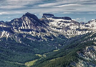
Coxcomb Peak is a 13,656-foot-elevation (4,162-meter) mountain summit located on the common boundary of Hinsdale County and Ouray County, in Colorado, United States. It is situated nine miles northeast of the community of Ouray, in the Uncompahgre Wilderness, on land managed by Uncompahgre National Forest. It is part of the San Juan Mountains which are a subset of the Rocky Mountains, and is situated west of the Continental Divide. Coxcomb ranks as the 171st-highest peak in Colorado, and topographic relief is significant as the south aspect rises 2,000 feet above Wetterhorn Basin in approximately one mile, and 4,400 feet above Cow Creek in three miles. Neighbors include Precipice Peak 2.7 miles to the north, Redcliff one-half mile north, Matterhorn Peak 2.3 miles to the east-southeast, and nearest higher neighbor Wetterhorn Peak 1.8 mile to the southeast. The mountain's descriptive name, which has been officially adopted by the United States Board on Geographic Names, was in use since at least 1906 when Henry Gannett published it in the Gazetteer of Colorado.