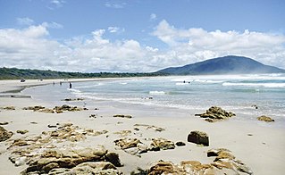
Old Bar is a coastal town in New South Wales, Australia in Mid-Coast Council. It lies around 18 kilometres (11 mi) east of Taree on the Mid North Coast, and around 315 kilometres (196 mi) north of Sydney.
Pelican Point may refer to:

Edward River, or Kyalite River, an anabranch of the Murray River and part of the Murray–Darling basin, is located in the western Riverina region of south-western New South Wales, Australia.
The Minnamurra River, an open mature wave dominated barrier estuary, is located in the Illawarra region of New South Wales, Australia.

Fish Point is a point in the north-eastern corner of East Wallabi Island in the Houtman Abrolhos island chain off the coast of Western Australia. It is located at 28°25′40″S113°44′34″E. It sits at the foot of Flag Hill, the highest peak on East Wallabi Island, and its western edge looks out onto Turtle Bay.
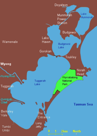
The Budgewoi Lake is a lagoon that is part of the Tuggerah Lakes, that is located within the Central Coast Council local government area in the Central Coast region of New South Wales, Australia. The lake is located near the settlement of Budgewoi and is situated about 100 kilometres (62 mi) north of Sydney.
Brokers Point or Brokers Nose or Corrimal Peak or Brokers Peak, is a point on the Illawarra Range, in the state of New South Wales, Australia.
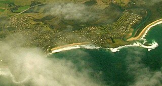
East Wallabi Island is an island in the Wallabi Group of the Houtman Abrolhos, located in the Indian Ocean off the west coast of mainland Australia.
West Wallabi Island is an island in the Wallabi Group of the Houtman Abrolhos, in the Indian Ocean off the west coast of mainland Australia.
Blicks River, a perennial stream that is part of the Clarence River catchment, is located in the Northern Tablelands district of New South Wales, Australia.
Bobo River, a mostly perennial stream of the Clarence River catchment, is located in the Northern Tablelands district of New South Wales, Australia.

Corang River is a perennial river of the Shoalhaven catchment located in the Southern Tablelands region of New South Wales, Australia.
The Tarcutta Creek, part of the Murray Darling basin, is mostly a perennial stream located in the Riverina region of New South Wales, Australia.
Wallingat River, a watercourse of the Mid-Coast Council system, is located in the Mid North Coast district of New South Wales, Australia.

Greenwell Point is a town in the Shoalhaven region of New South Wales, Australia. It is about 13 km east of Nowra on the South Coast. At the 2021 census, the town had a population of 1,245.

The Wiebbe Hayes Stone Fort on West Wallabi Island is the oldest surviving European building in Australia and was built in 1629 by survivors of the Batavia shipwreck and massacre. West Wallabi Island is 63 km (39 mi) from the coast of Western Australia.
The Chandlers Creek, a perennial stream that is part of the Clarence River catchment, is located in the Northern Tablelands region of New South Wales, Australia.
The Georges Creek, a perennial stream that is part of the Macleay River catchment, is located in the Northern Tablelands and Mid North Coast regions of New South Wales, Australia.
The Pipers Creek, a watercourse that is part of the Hastings River catchment, is located in the Mid North Coast region of New South Wales, Australia.

MidCoast Council is a local government area that is located in the Mid North Coast region of New South Wales, Australia. The council was formed on 12 May 2016 through a merger of the Gloucester Shire, Great Lakes and City of Greater Taree Councils.
