Boulevard Oaks, Houston

Last updated

Boulevard Oaks Historic District
BoulevardOaksSignTX.JPG
Boulevard Oaks street sign
USA Texas location map.svg
Red pog.svg
Usa edcp location map.svg
Red pog.svg
LocationRoughly bounded by
North and South Boulevards between Parkway and Wilton. Houston, Texas
United States
Coordinates 29°43′37″N95°24′13″W / 29.72694°N 95.40361°W / 29.72694; -95.40361
Area56 acres (23 ha)
ArchitectWatkin, William Ward; et al.
Architectural styleLate 19th And 20th Century Revivals
NRHP reference No. 02000117 [1]
Added to NRHPFebruary 22, 2002

Boulevard Oaks is a neighborhood in Houston, Texas, United States, containing 21 subdivisions north of Rice University and south of U.S. Highway 59. Developed primarily during the 1920s and 1930s, Boulevard Oaks contains two National Register historic districts, Broadacres and Boulevard Oaks. [2] [3] The Boulevard Oaks Civic Association (BOCA) is the common civic association for all 21 subdivisions.

Contents

Boulevard Oaks is in Texas's 7th congressional district. [4]

History

17 communities developed over a period of two decades. In 1980 the Boulevard Oaks Civic Association was created to provide a single management organization for all 17 areas. [5]

The Poe Elementary School bombing occurred in 1959.

The National Register of Historic Places designated the Boulevard Oaks Historic District, located within Boulevard Oaks and roughly bordered by North Boulevard, South Boulevard, Hazard Street, and Mandell Street, as a historical district on February 22, 2002. [1]

Composition

The subdivisions of Boulevard Oaks are Chevy Chase, Edgemont, Ormond Place, Broadacres, Vassar Place, Ranch Estates, North Edgemont, West Edgemont, West Ormond Place, Cresmere Place, Cherokee, Vassar Court, Greenbriar Addition, Keithly Place, Sunset Court, Sunset Place, Sunset Estates, Cheyne Walk, Hermann Hospital Estates, Wroxton Court, and portions of the O. Smith Survey. [6]

The Simon and Mamie Minchen House is within Boulevard Oaks.

Government and infrastructure

Boulevard Oaks is a part of the University Place Super Neighborhood Council. [7]

The community is in Houston City Council District C. [8]

The Houston Police Department's South Central Patrol Division, [9] headquartered at 2022 St. Emanuel., [10] serves the neighborhood.

The Southampton/Boulevard Oaks Patrol Service provides private security to the community and to Southampton. [11]

Harris Health System (formerly Harris County Hospital District) designated Northwest Health Center in northwest Houston for ZIP code 77098, and Martin Luther King Health Center in southeast Houston for ZIP code 77005. The nearest public hospital is Ben Taub General Hospital in the Texas Medical Center. [12]

Schools

Poe Elementary School PoeESSunny.JPG
Poe Elementary School

The neighborhood is zoned to Houston Independent School District (HISD) schools. Poe Elementary School is located in the Chevy Chase subdivision in Boulevard Oaks. [6] Zoned schools include Poe Elementary School, Lanier Middle School (in the Montrose neighborhood), and Lamar High School (in the Upper Kirby neighborhood). [13]

Area K-8 private schools include Presbyterian School in Houston. Area 9-12 high schools include St. Agnes Academy and Strake Jesuit College Preparatory in Houston. K-12 private schools include St. John's School in Houston and The Kinkaid School in Piney Point Village. [13]

Parks and recreation

The Vassar Spaceway Park is located in Boulevard Oaks. [14] [15] It was dedicated as a municipal park in the late 1980s. Evalyn Krudy, the director of the University Place Super Neighborhood Council, said that since the creation of the park, it had been affected by drainage issues. [14] The Boulevard Oaks association received $5,000 in matching grant funds from the Matching Grant Program of the City of Houston Planning and Development Department. The funds were used to create a comprehensive drainage and maintenance plan to prevent standing water from accumulating and to beautify the park. [14]

Neighborhood in film

Boulevard Oaks appears in the films Terms of Endearment (1983), Rushmore (1998), Sidekicks (1992), My Best Friend is a Vampire (1988). Ms. Cross' temporary home in Rushmore is on North Boulevard. Mr. Blume and Ms. Cross also take a walk down North Boulevard in the film. In Terms of Endearment, Garrett Breedlove and Aurora take a walk down North Boulevard.

Media

The Houston Chronicle is the area regional newspaper.

The West University Examiner is a local newspaper distributed in the community [ permanent dead link ].

See also

Related Research Articles

<span class="mw-page-title-main">River Oaks, Houston</span> Subdivision in Houston, Texas, USA

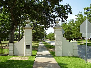
River Oaks is a residential community located in the center of Houston, Texas, United States. Located within the 610 Loop and between Downtown and Uptown, the community spans 1,100 acres (450 ha). Established in the 1920s by brothers Will Hogg and Michael Hogg, the community became a well-publicized national model for community planning. Real estate values in the community range from $1 million to over $20 million. River Oaks was also named the most expensive neighborhood in Houston in 2013. The community is home to River Oaks Country Club, which includes a golf course designed by architect Donald Ross and redesigned in 2015 by Tom Fazio.

<span class="mw-page-title-main">Bob Lanier Middle School</span> Public school in Houston, Texas

Bob Lanier Middle School, formerly Sidney Lanier Junior High School/Middle School, is a middle school in Houston, Texas, United States, with a ZIP code of 77098. Lanier, a school of the Houston Independent School District (HISD), handles grades 6 through 8. Named after former mayor of Houston Bob Lanier, the school is located in Neartown and near Montrose and has both neighborhood non-magnet and Vanguard/IBMYP gifted/talented programs. Lanier's neighborhood program serves Montrose, Afton Oaks, Boulevard Oaks, River Oaks, Southampton, and other communities.

<span class="mw-page-title-main">Upper Kirby</span> Neighborhood of Houston in Harris County, Texas, United States

Upper Kirby is a commercial district in Houston, Texas, United States. It is named after Kirby Drive, so indirectly takes its name from John Henry Kirby.

<span class="mw-page-title-main">Afton Oaks, Houston</span>

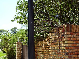
Afton Oaks is a deed-restricted "Inner Loop" upscale residential community of approximately 525 homes in Houston, Texas, United States. Afton Oaks is located inside Interstate 610 near the Galleria and Highland Village. The neighborhood is bounded on the north by Westheimer Road, on the east by Union Pacific railroad tracks, on the south by Interstate 69/U.S. Highway 59, and on the west by Interstate 610.

<span class="mw-page-title-main">Southampton, Houston</span>

Southampton Place, also known as Southampton, is a neighborhood located in Houston, Texas. The Southampton Civic Club Inc. is the homeowners' association.

<span class="mw-page-title-main">Rice Military, Houston</span>

Rice Military is a neighborhood in Houston, Texas, United States. The Beer Can House is located in Rice Military.

<span class="mw-page-title-main">Old Braeswood, Houston</span>

Old Braeswood is a neighborhood of single family homes in Houston, Texas, United States. It is generally bounded by South Main, North Braeswood, Kirby Drive, and Holcombe. The Texas Medical Center, Rice University, Rice Village, and the NRG Center complex are all within a one-mile radius. Nearby neighborhoods include Southgate, West University Place and Braeswood Place.

<span class="mw-page-title-main">Poe Elementary School (Houston)</span> United States historic place

Edgar Allan Poe Elementary School is a primary school located at 5100 Hazard Street in Houston, Texas, United States. A part of the Houston Independent School District (HISD), the school, which was built during the 1920s, is located in the Chevy Chase subdivision of the Boulevard Oaks neighborhood west of Rice University. The school, a National Register of Historic Places (NRHP) historic district contributing property of Boulevard Oaks, was named after Edgar Allan Poe.

Eastwood is a historic neighborhood in the East End area of Houston, Texas, United States. Eastwood maintains Houston’s largest intact collection of Craftsman, Arts & Crafts, Foursquare and Mission style architecture.

<span class="mw-page-title-main">University Oaks, Houston</span>

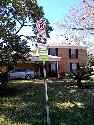
University Oaks is a subdivision in southeast Houston with approximately 240 homes located adjacent to the University of Houston. It is bounded by Wheeler Avenue to the north, South MacGregor Way to the south, Calhoun Road to the east, and Cullen Boulevard to the west.

<span class="mw-page-title-main">Maplewood South–North, Houston</span>

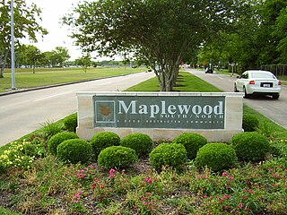
Maplewood South/North is a group of subdivisions in Houston, Texas.

<span class="mw-page-title-main">Willowbend, Houston</span>

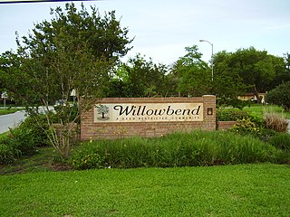
Willowbend is a neighborhood in near Southwest Houston, Texas.

<span class="mw-page-title-main">Woodland Heights, Houston</span> Historic Neighborhood in Houston, Texas

The Woodland Heights neighborhood is one of the oldest and most historic in Houston, Texas. It encompasses approximately 2000 homes in the 77009 ZIP code and is bounded on the north by Pecore Street, on the west by Studewood Street, on the east by I-45, and on the south by I-10.

<span class="mw-page-title-main">Glenbrook Valley, Houston</span>

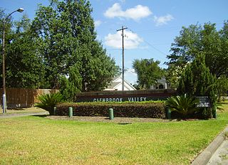
Glenbrook Valley is a subdivision located in Houston, Texas, United States.

Sunset Terrace and Montclair Place are two Inner Loop neighborhoods of Harris County, Texas, United States. The two subdivisions are served by the Sunset Terrace/Montclair Civic Association.

Morningside Place is a group of subdivisions located in Houston, Texas, United States.

<span class="mw-page-title-main">Shadyside, Houston</span>

Shadyside is a private, walled subdivision of 16 houses in Houston, Texas. In 2012 Terrence McCoy of the Houston Press said that Shadyside has a "sense of exclusivity, or as Heritage Texas Properties puts it, 'mystique,'" which caused many prominent figures from Houston to settle in Shadyside and continue doing so for a period of almost 100 years.

<span class="mw-page-title-main">Broadacres, Houston</span> United States historic place

Broadacres is a subdivision in Houston, Texas, United States, within the Boulevard Oaks community. It is located north of Bissonnet Street, south of U.S. Route 59, west of the Houston Museum District, and east of other subdivisions of Boulevard Oaks. The neighborhood is known for its large lots, historic preservationism, broad tree canopies, wide streets with medians, and affluence.

<span class="mw-page-title-main">Hyde Park, Montrose, Houston</span> Neighborhood in Houston, Texas, United States

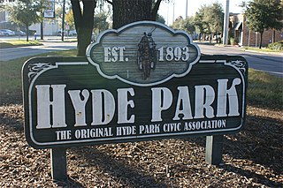
Hyde Park is a historic community located in the Montrose neighborhood of Houston, Texas. Its southeast boundary is the intersection Montrose Boulevard and Westheimer. The neighborhood was established in the late 1800s on the summer farm of the second President of the Republic of Texas, Mirabeau Lamar. In the 1970s, Hyde Park became a central part of the Gay Rights Movement in Houston. Like much of Montrose, the neighborhood is now experiencing significant gentrification, and is home to an abundance of restaurants, including Mexican, Italian, Greek, American, Lebanese, coffee houses, and numerous bars.

References

  1. 1 2 "National Register Information System". National Register of Historic Places . National Park Service. July 9, 2010.
  2. "Broadacres Historic District". NPGallery Digital Asset Management System. National Park Service. April 16, 1980. Retrieved May 20, 2017.
  3. "Boulevard Oaks Historic District". NPGallery Digital Asset Management System. National Park Service. February 22, 2002. Retrieved May 20, 2017.
  4. "Archived copy". nationalatlas.gov. Archived from the original on April 17, 2006. Retrieved January 12, 2022.{{cite web}}: CS1 maint: archived copy as title (link)
  5. "Information Archived 2016-08-26 at the Wayback Machine ." Boulevard Oaks Civic Association. Retrieved on July 25, 2017.
  6. 1 2 "Civic Association Architectural Review/Deed Restriction Contacts Archived 2007-07-03 at the Wayback Machine ." Boulevard Oaks. Retrieved on December 25, 2012.
  7. Galloway, Melissa Bech. "Neighborhood making strides / University Place council targets traffic woes, security." Houston Chronicle . Thursday October 11, 2001. ThisWeek 17. Retrieved on October 22, 2012.
  8. City of Houston, Council District Maps, District C Archived 2012-12-24 at the Wayback Machine ." City of Houston. Retrieved on November 5, 2011.
  9. "Crime Statistics for South Central Patrol Division." City of Houston.
  10. "VOLUNTEER INITIATIVES PROGRAM - Citizens Offering Police Support." City of Houston.
  11. "Patrol Service." Boulevard Oaks. Retrieved on July 25, 2017.
  12. "Clinic/Emergency/Registration Center Directory By ZIP Code". Harris County Hospital District. November 19, 2001. Archived from the original on November 19, 2001. Retrieved April 8, 2021. - See ZIP codes 77005 and 77098. See this map for relevant ZIP code.
  13. 1 2 "Information: Schools Archived 2016-08-26 at the Wayback Machine ." Boulevard Oaks. Retrieved on December 4, 2008.
  14. 1 2 3 Reynolds, Patrick. "Southwest Houston groups receive improvement grants." Houston Chronicle . Thursday September 27, 2001. Retrieved on October 23, 2012.
  15. "Our Parks O-Z Archived 2012-10-07 at the Wayback Machine ." City of Houston. Retrieved on October 23, 2012.

Further reading