Shenandoah, Houston

Last updated
Shenandoah ShenandoahHoustonmarker.jpg
Shenandoah
Shenandoah ShenandoahsignHoustonTX.JPG
Shenandoah

Shenandoah is a subdivision in Houston, Texas, United States.

Contents

Shenandoah, located outside the 610 Loop, inside Beltway 8, and south and east of U.S. Highway 59 (Southwest Freeway), is surrounded by a community of apartment complexes called Gulfton. Shenandoah's sections include Shenandoah Section 1, Shenandoah Section 2, Shenandoah Section 3. The Shenandoah Civic Association has control over all of these sections and also controls a portion of the neighboring Sigrid subdivision.

History

Shenandoah, the first subdivision in the area, opened in the mid-1950s on former greenfield. Shenandoah had 16 blocks of ranch-style homes. [1] The Shenandoah Civic Association opened in 1956; since the City of Houston has no zoning, the Shenandoah Civic Association's main goal is to enforce deed restrictions which regulate construction of housing and prevent businesses being operated from homes. [2]

Robert Fisher and Lisa Taafe, authors of the 1997 article Public Life in Gulfton: Multiple Publics and Models of Organization, said that the sudden demographic shifts in the late 1970s and 1980s "profoundly affected" Shenandoah as bars, warehouses, and nightclubs appeared next to Shenandoah houses. Many area apartment owners let their units decay from a lack of maintenance. The factors threatened Shenandoah property values, therefore the Shenandoah Civic Association added a security patrol, lobbied for the Houston City Council to end liquor licenses of bars adjacent to Shenandoah, engaged in neighborhood beautification, and supported the establishment of a Houston Police Department storefront in Gulfton. Generally the Shenandoah Civic Association did not involve itself in matters related to the apartments surrounding the subdivision. [3]

In April 1992 Bob Lanier, the Mayor of Houston, named Gulfton as one of ten Houston neighborhoods targeted by a city revitalization program. [4] One aspect of Lanier's project consisted of building barricades around the Shenandoah subdivision to reduce traffic and crime; the Shenandoah Civic Association supported and pursued the street closures. [1] [5] The Gulfton Area Neighborhood Organization (GANO) opposed Shenandoah's barricading. [6] All of the other advocacy groups, except for some GAAC members, opposed the closure. Members of the community groups said that the closure has racist motives, that the closures would not effectively control crime, that the city was not using funds wisely, and that the closures would harm local businesses. [5]

Fisher and Taafe that the Shenandoah Civic Association was a conservative organization made of mostly middle class residents that aimed to maintain the neighborhood and its property values. [7] Fisher and Taafe said that after Central American Refugee Center (CARECEN) merged into GANO, the combined organization was unlikely to cooperate with the Shenandoah Civic Association. [6] In November 1995, when the Texas State Legislature established a juvenile crime prevention grant for Gulfton, GANO cooperated with the Shenandoah Civic Association to accomplish the goal. [8]

Education

Primary and secondary schools

Shenandoah is within the Houston Independent School District. [9]

Cunningham Elementary School serves Shenandoah Section 1, Shenandoah Section 2, and Shenandoah Section 3. [10] Braeburn Elementary School serves Sigrid. [11] Shenandoah is zoned to Jane Long Middle School, with Pin Oak Middle School as an option, and Margaret Long Wisdom High School (formerly Robert E. Lee High School), with Lamar and Westside high schools as options. [12] [13] [14] [15]

Cunningham Elementary School opened in 1953, Braeburn Elementary School opened in 1956, Long Middle School opened in 1958, and Lee High School opened in 1962. [16] In the early 2000s, Braeburn served portions of Shenandoah Section 1 and Shenandoah Section 2, while serving all of Shenandoah Section 3 and Sigrid. [17] Cunningham served the parts of Shenandoah Section 1 and Shenandoah Section 2 not covered by Braeburn. [18] When Westside opened in 2000, [19] residents of the Lee attendance boundary gained the option to attend Westside instead of Lee, with no free transportation provided. [20]

Related Research Articles

Bellaire, Texas Enclave city in Texas, United States

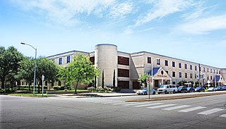
Bellaire is a city in southwest Harris County, Texas, United States, within the Houston–Sugar Land–Baytown metropolitan area. As of the 2020 U.S. census, the city population was 17,202. It is surrounded by the cities of Houston and West University Place. Bellaire is known as the "City of Homes", owing to its mostly residential character; but it has offices along the I-610 Loop within the city limits.

Bellaire High School (Texas) Public secondary school in Bellaire, Texas, United States

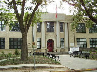
Bellaire High School is a comprehensive, public secondary school in Bellaire, Texas. Part of the Houston Independent School District, it serves the incorporated city of Bellaire, the Houston community of Meyerland, and other adjacent Houston neighborhoods. It has a racially and socioeconomically diverse student body.

Sharpstown, Houston

Sharpstown is a master-planned community in the Southwest Management District, Southwest Houston, Texas It was one of the first communities to be built as a master-planned, automobile centered community and the first in Houston. Frank Sharp (1906–1993), the developer of the subdivision, made provisions not only for homes but also for schools, shopping and recreation areas. While this model has been duplicated countless times in the past fifty years, at the time it was quite revolutionary, attracting national media attention. The development was dedicated on March 13, 1955.

Westside High School (Houston) Suburban public secondary school in Houston, TX

Westside High School is a secondary school in Houston, Texas, United States. It serves grades 9 through 12 and is part of the Houston Independent School District.

Margaret Long Wisdom High School Public, secondary school in Houston, Texas , United States

Margaret Long Wisdom High School, formerly Robert E. Lee High School, is a publicly funded secondary school located in Southwest Houston, Texas, United States 77057. The Houston Independent School District, the 7th largest school district in the United States, operates Wisdom, a public admission school that enrolls grades 9 through 12. The school serves the neighborhoods of Uptown, Briargrove, Westchase, and Gulfton areas of the city of Houston. Houston Independent School District will submit construction documents in 2016–2017 school year. After the construction documents are submitted, They will vote to seek approval for the new school.

Eastwood is a historic neighborhood in the East End area of Houston, Texas, United States. Eastwood maintains Houston’s largest intact collection of Craftsman, Arts & Crafts, Foursquare and Mission style architecture.

Maplewood, Houston

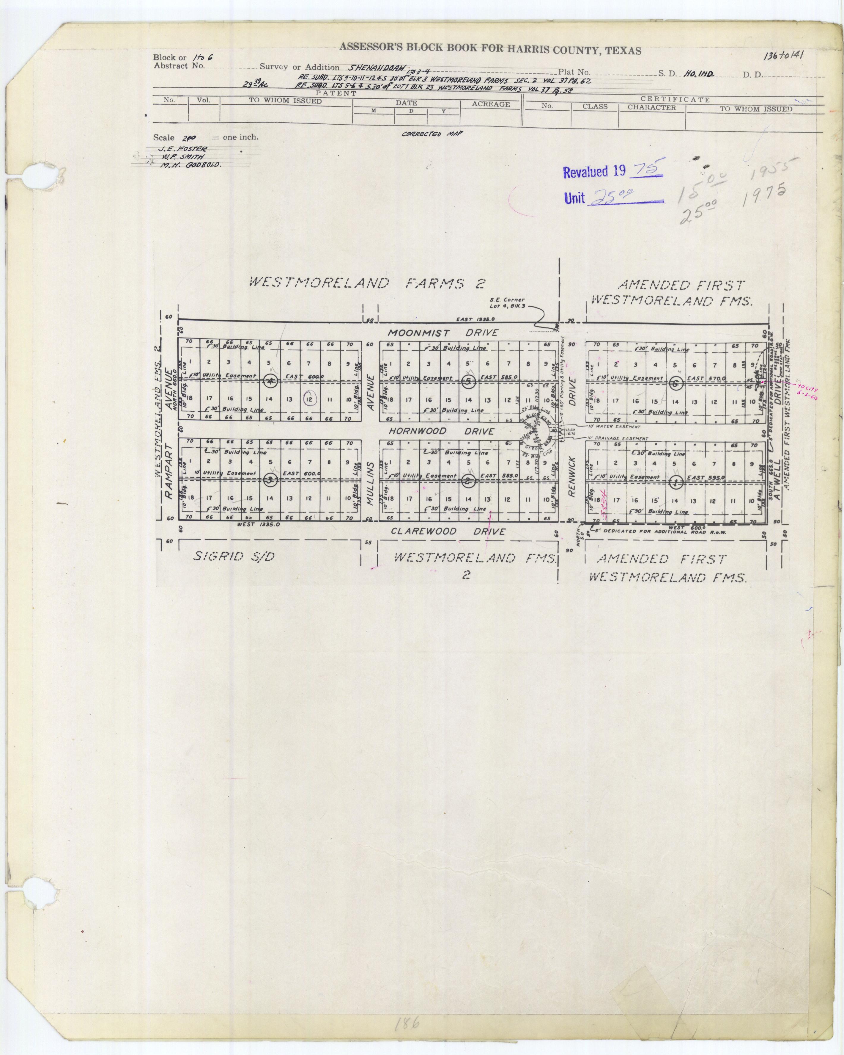
Maplewood is a community in Houston, Texas located outside the 610 Loop, southwest of Downtown Houston. It consists of 524 houses. They are one-story and two-story houses, as two stories is the limit allowed by the subdivision. The oldest houses were built in the early 1950s. Maplewood is located along Beechnut, Hillcroft, and Renwick.

Braeburn, Houston

Braeburn is a community of subdivisions in southwest Houston, Texas along Brays Bayou west of Hillcroft Avenue and south of the Sharpstown community. The first of these middle class subdivisions was developed after World War II at a time when the Richmond Farm-to-Market Road provided the route into the city, rather than U.S. Highway 59. Development continued into the 1970s. The Braeburn Country Club is located in the center of the community. Subdivisions found here include Robindell, Braeburn Terrace, Braeburn Glen, Larkwood, Braeburn Valley, Bonham Acres, Braes Timbers and—the acreage lot subdivision—Brae Acres. The area also includes commercial and multi-family developments. Braeburn is notable for its large number of mid-century modern homes, tree lined streets, and location close to the Galleria, the Texas Medical Center, Reliant Park, the major freeways- 59, 610 and the Beltway. The communities of Braeburn have in recent years formed the Braeburn Superneighborhood, a coalition of Home Owner Associations, in order to interact more effectively with the City of Houston and other area agencies. The Brays Bayou hike and bike trail runs through the community, providing easy access to over 15 miles of excellent trails.

Glenbrook Valley, Houston

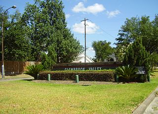
Glenbrook Valley is a subdivision located in Houston, Texas, United States.

Gulfton, Houston Neighborhood of Houston in Texas, United States of America

Gulfton is a community in Southwest Houston, Texas, United States that includes a 3.2 sq mi (8.3 km2) group of apartment complexes that primarily house refugee and immigrant populations. It is located between the 610 Loop and Beltway 8, west of the City of Bellaire, southeast of Interstate 69/U.S. Highway 59, and north of Bellaire Boulevard.

Briargrove Park (BGP) is a subdivision in western Houston, Texas, United States. It has about 1,480 houses. It is bounded by Beltway 8, the Buffalo Bayou, Gessner Road, and Westheimer Road.

Riverside Terrace is a neighborhood in Houston, Texas, United States. It is along Texas State Highway 288 and north of the Texas Medical Center and located near Texas Southern University and University of Houston. There about 20 sections of Riverside Terrace that span across North and South MacGregor. The community, formerly an affluent Jewish neighborhood, became an affluent community for African Americans in the 1950s and '60s. It is still predominantly African American neighborhood with different income levels. It has been undergoing a gradual change in demographics and aesthetics due to gentrification efforts since the early 2000s.

Quail Valley is a neighborhood dating from 1969 of Missouri City, in Fort Bend County, Texas, USA.

Southwest Management District District in Houston, Texas

Southwest Management District, formerly Greater Sharpstown Management District, is a district in Houston, Texas, United States. The district is split into 6 neighborhoods: Sharpstown, Chinatown, Mahatma Gandhi District/Little India, Westwood, Harwin, and University.

Ponderosa Forest is a residential neighborhood in unincorporated northwest Harris County, Texas, United States. It is located near Farm to Market Road 1960, also referred to as Cypress Creek Parkway.

Jane Long Academy Public secondary school in the United States

Jane Long Academy, formerly Jane Long Middle School, is a public grade 6-12 middle and high school in Sharpstown, Houston, Texas. It is a part of the Houston Independent School District. Long, in Sharpstown Section 1, serves portions of Sharpstown, Gulfton, and Shenandoah for middle school. Jane Long serves Sharpstown original sections 1, 1A, and 2. The campus has a grade 6-8 neighborhood program together with a 9-12 Futures Academy, a non-zoned high school program that offers an associate degree track. Las Américas Newcomer School, a school for new immigrants, is on the Long campus.

Briarhills, Houston Subdivision in Texas, United States

Briarhills is a subdivision in western Houston, Texas. The Briarhills Property Owners Association (POA) and the Briarhills Home Owners Association (HOA) serve Briarhills, Meadowbriar, and Oaks of Parkway.

Baker Montessori School School in Houston

Ella J. Baker Montessori School, formerly Woodrow Wilson Montessori School and Woodrow Wilson Elementary School, is a public K-8 Montessori school in the Cherryhurst Addition subdivision in the Neartown area of Houston, Texas. A part of the Houston Independent School District (HISD), Baker serves as the neighborhood elementary school for a section of Neartown, including a portion of Montrose. It also serves as a magnet school for all of HISD's territory. As of 2014 it is one of three public Montessori programs in Houston. It was the first HISD school to use the Montessori style for all students, as well as housing HISD's first Montessori middle school program. It was formerly named after President of the United States Woodrow Wilson and had its name changed in 2021 due to racist actions taken by the president; it is now named after civil rights activist Ella J. Baker.

References

  1. 1 2 Rogers, Susan. "Superneighborhood 27: A Brief History of Change." California Digital Library .
  2. Fisher, Robert and Lisa Taafe. "Public Life in Gulfton: Multiple Publics and Models of Organization." Community Practice: Models in Action. 38.
  3. Fisher, Robert and Lisa Taafe. "Public Life in Gulfton: Multiple Publics and Models of Organization." Community Practice: Models in Action. 38-39.
  4. Piller, Ruth. "Mayor lists 10 neighborhoods in revitalization-rebuilding plan." Houston Chronicle . April 11, 1992. Section A, Page 26.
  5. 1 2 Fisher, Robert and Lisa Taafe. "Public Life in Gulfton: Multiple Publics and Models of Organization." Community Practice: Models in Action. 39.
  6. 1 2 Fisher, Robert and Lisa Taafe. "Public Life in Gulfton: Multiple Publics and Models of Organization." Community Practice: Models in Action. 44.
  7. Fisher, Robert and Lisa Taafe. "Public Life in Gulfton: Multiple Publics and Models of Organization." Community Practice: Models in Action. 46-47.
  8. Fisher, Robert and Lisa Taafe. "Public Life in Gulfton: Multiple Publics and Models of Organization." Community Practice: Models in Action. 47.
  9. "NeighborhoodWithSubdivisionsMarked.pdf Archived 2009-05-30 at the Wayback Machine (Composite map). Harris County Appraisal District. Accessed October 6, 2008.
  10. "Cunningham Elementary Attendance Zone Archived 2008-02-16 at the Wayback Machine ." Houston Independent School District . Accessed October 6, 2008.
  11. "Braeburn Elementary Attendance Zone Archived 2008-02-16 at the Wayback Machine ." Houston Independent School District . Accessed October 6, 2008.
  12. "Long Middle Attendance Zone Archived 2014-04-09 at the Wayback Machine ." Houston Independent School District . Accessed October 6, 2008.
  13. "Pin Oak Middle School." The Southwest District. Houston Independent School District.
  14. "Lee High School Attendance Zone Archived 2007-02-03 at the Wayback Machine ." Houston Independent School District . Accessed October 6, 2008.
  15. Home Page as of May 9, 2005. Lee High School .
  16. "School Histories: the Stories Behind the Names Archived 2012-07-28 at the Wayback Machine ." Houston Independent School District . Accessed September 24, 2008.
  17. "Braeburn EL Boundary Map." Houston Independent School District . Retrieved on May 6, 2009.
  18. "Cunningham EL Boundary Map." Houston Independent School District . Retrieved on May 6, 2009.
  19. Viadero, Debra. "Personal Touches." Education Week . June 16, 2004.
  20. "Westside and Lee HS Boundaries." Houston Independent School District . October 3, 2000. Retrieved on May 7, 2009.

Coordinates: 29°42′40″N95°29′06″W / 29.711°N 95.485°W / 29.711; -95.485