Related Research Articles

Galena Park is a city in Harris County, Texas, United States, within the Houston–Sugar Land–Baytown metropolitan area. The population was 10,887 at the 2010 census.
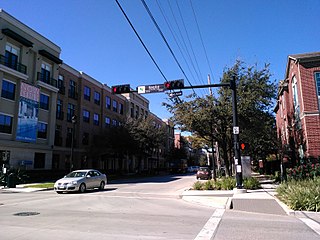
Midtown is a central neighborhood of Houston, located west-southwest of Downtown. Separated from Downtown by an elevated section of Interstate 45, Midtown is characterized by a continuation of Downtown's square grid street plan, anchored by Main Street and the METRORail Red Line. Midtown is bordered by Neartown (Montrose) to the west, the Museum District to the south, and Interstate 69 to the east. Midtown's 325 blocks cover 1.24 square miles (3.2 km2) and contained an estimated population of nearly 8,600 in 2015.

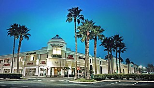
Sharpstown is a master-planned community in the Southwest Management District, Southwest Houston, Texas It was one of the first communities to be built as a master-planned, automobile centered community and the first in Houston. Frank Sharp (1906–1993), the developer of the subdivision, made provisions not only for homes but also for schools, shopping and recreation areas. While this model has been duplicated countless times in the past fifty years, at the time it was quite revolutionary, attracting national media attention. The development was dedicated on March 13, 1955.
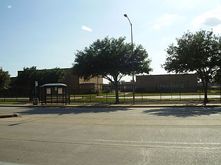
Harrisburg is a community that is now located within the city of Houston, Texas, United States.
Meyerland is a 6,000-acre (9 sq mi) community in southwest Houston, Texas, outside of the 610 Loop and inside Beltway 8. The neighborhood is named after the Meyer family, who bought and owned 6,000 acres (24 km²) of land in southwest Houston.
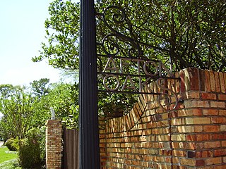
Afton Oaks is a deed-restricted "Inner Loop" upscale residential community of approximately 525 homes in Houston, Texas, United States. Afton Oaks is located inside Interstate 610 near the Galleria and Highland Village. The neighborhood is bounded on the north by Westheimer Road, on the east by Union Pacific railroad tracks, on the south by Interstate 69/U.S. Highway 59, and on the west by Interstate 610.

Acres Homes is a neighborhood located in northwest Houston, Texas. The 9-square-mile (23 km2) mile area is loosely bounded by the city limits and West Gulf Bank Road to the north; Pinemont Drive to the south; North Shepherd Drive to the east; and Alabonson Drive to the west. Historically, it has been predominantly African American. Unincorporated for decades, it was annexed to Houston in 1967.

Sunnyside is a community in southern Houston, Texas, United States, south of Downtown Houston.

Briargrove is a neighborhood in Houston, Texas, United States, near Uptown Houston.
Pecan Park is a neighborhood in Houston, Texas.
Independence Heights is a community in Houston, Texas, bordered by 40th Street east of N. Main and 40th Street west of N. Main to the north, Yale Street to the west, the 610 Loop to the south, and Airline Drive to the east. The Super Neighborhood boundary created by the City of Houston is bordered by Tidwell to the north, Shepherd Drive to the west, the 610 Loop to the south, and Interstate 45 to the east.

Clinton Park is a neighborhood located in Houston, Texas. Clinton Park is located outside the 610 Loop in eastern Houston. Clinton Park is predominantly African-American. Carolyn Campbell of KHOU-TV described Clinton Park, close to the Port of Houston, as "small" and "isolated."

Magnolia Park is an area of the East End, Houston, Texas, located near the Houston Ship Channel. One of the oldest Hispanic neighborhoods in the City of Houston, Magnolia Park was formerly incorporated as the City of Magnolia Park in eastern Harris County.

Kashmere High School is a secondary school in Houston, Texas that serves grades 9 through 12; it is a part of the Houston Independent School District. It is located in the Trinity Gardens neighborhood, and its namesake is the nearby Kashmere Gardens neighborhood.
Near Northside is a historic neighborhood located in Northside, Houston, Texas. Near Northside is primarily occupied by people of Hispanic descent.
Port Houston is a neighborhood located on the East Side of Houston, Texas, United States.
Francis Scott Key Middle School is a public middle school in the Kashmere Gardens area of Houston, Texas, United States. It is within the Houston Independent School District.
Kashmere Gardens is a historically African-American neighborhood in the northern 610 Loop area in Houston, Texas, United States. A group of single-family houses, many of which have large lots, Kashmere Gardens is between an industrial area and a rail corridor.

Settegast is a neighborhood in northeast Houston with a person/acre average between 1-5. The community is bordered by the 610 Loop, the Union Pacific Railroad Settegast Yard, and the old Beaumont Highway. The community has many small wood-frame houses and empty lots. Habitat for Humanity has a prominent stake in the area, and a community garden is underway. There are few commercial and industrial uses within Settegast. Also, contemporary housing has started to show itself within new construction in the area. The City of Houston designated Settegast as a Houston HOPE neighborhood.

The Westmoreland Historic District is a neighborhood in Neartown Houston, Texas. It is west of Spur 527, between Westheimer Road and West Alabama Street.
References
- 1 2 Longoria, Rafael and Susan Rogers. "The Rurban Horseshoe." Cite 73. The Rice Design Alliance, (Northern Hemisphere) Winter 2008. Page 20. Retrieved on February 24, 2010.
- ↑ "Annexations in Houston Or How we grew to 667 square miles in 175 years." City of Houston Planning and Development Department. p. 26 of 62. Retrieved on February 21, 2017.
- ↑ Longoria, Rafael and Susan Rogers. "The Rurban Horseshoe." Cite 73. The Rice Design Alliance, (Northern Hemisphere) Winter 2008. Pages 18-19. Retrieved on February 24, 2010.
- ↑ "Super Neighborhood Resource Assessment No. 48 Trinity/Houston Gardens" (PDF). City of Houston. Retrieved 2019-08-14.
- ↑ City of Houston, Council District Maps, District B Archived 2012-06-25 at the Wayback Machine ." City of Houston. Retrieved on November 5, 2011.
- ↑ "Clinic/Emergency/Registration Center Directory By ZIP Code". Harris County Hospital District. 2001-11-19. Archived from the original on 2001-11-19. Retrieved 2021-04-08. - See ZIP code 77028. See this map for relevant ZIP code.
- ↑ "Home." McGowen Elementary School. Retrieved on June 30, 2013.
- ↑ "Houston Gardens Elementary Attendance Zone." Houston Independent School District . Retrieved on February 24, 2010.
- ↑ "Key Middle Attendance Zone Archived 2012-02-25 at the Wayback Machine ." Houston Independent School District . Retrieved on February 24, 2010.
- ↑ "Kashmere High School Attendance Zone Archived 2012-03-10 at the Wayback Machine ." Houston Independent School District . Retrieved on February 24, 2010.
- ↑ "Our Parks G-N." City of Houston. Retrieved on February 25, 2010.
