Denver Harbor, Houston

Last updated
Denver Harbor entrance sign DenverHarborsign.JPG
Denver Harbor entrance sign

Denver Harbor is a historic community located in eastern Houston, Texas, United States near the Houston Ship Channel. The community, bounded by Wallisville Road, the Union Pacific Railroad, and the Port Terminal Railroad Association, was first settled in the 1890s and platted in 1911 and 1913. [1] The community includes many historic bungalow and cottage homes. [2]

Contents

Denver Harbor is a mostly Hispanic community. [3]

History

Denver Harbor was first settled in the 1890s and platted in 1911 and 1913. The four original subdivisions were: Denver, Harbor, Harbordale, and Liberty Heights. [1] The names "Denver" and "Harbor" merged and became the name "Denver Harbor," which describes the entire community. [4] Many early residents of Denver Harbor were Texans who left farms for the city neighborhood to make a better life for themselves and their families. These residents found work on the railroads and industrial companies that were established along the Houston Ship Channel. [1] Greeks, Italians, and Poles settled Denver Harbor. [5] The City of Houston annexed the Denver Harbor and Houston Harbor communities in 1929, adding 885 acres (358 ha) of land to the city limits. [6]

On June 1, 1939, the word "Podunk" was mysteriously written on the side of the local water tower. The city tried repeatedly to cover over the word, however the name would always reappear within days. [1] Inspired by the defiance of the sign's unknown painter, area residents soon began to identify as Podunkers. The names was adopted by a local youth basketball team known as the Podunk Skunks. [1] The names, used in the 1930s and 1940s, was in reference to how Denver Harbor was considered to be "out-of-the-way." The slang became known after area children painted the word on a water tower. [7] Jay Grady, an area resident, stated in a 2007 Houston Chronicle article that residents felt proud of the nickname since back then Denver Harbor was barely in the eastern city limits of Houston and that "it was kind of like living in the country rather than being in the city." Grady added that the community was "always been kind of a stepchild to the city of Houston, kind of a hardscrabble community, mostly blue-collar workers on the eastern edge of the city limits. We felt like we lived in the country rather than in town." [4] As the population transitioned from working-class White Americans to Hispanic Americans the nickname was no longer used. [7]

Dr. Jay Grady self-published 2,000 copies of his book Where the Hell is Podunk, Texas?, which is about Denver Harbor. In addition he lobbied to have Denver Harbor declared as the "official mythical town of Texas" due to the "Podunk" nickname. A Texas House of Representatives resolution that would have declared this was passed by the House and then rejected by most of the members of the Texas Senate, including Mario Gallegos, a Texas senator whose district includes Denver Harbor. [7] In August 2007 Tropical Storm Erin flooded streets and houses in Denver Harbor. [8] By 2008 residents from the area vocally opposed a perceived increase in crime. [9]

Government and infrastructure

Denver Harbor Post Office DenverHarborPostOfficeHoustonTX.JPG
Denver Harbor Post Office

The city operates the Denver Harbor Multi-Service Center at 6402 Market Street. [10] The multi-service center provides several services such as child care, programs for elderly residents, food pantry, WIC, and rental space. [10]

Fire Station 27 HFDStation27.JPG
Fire Station 27

It is a part of Houston City Council District H. [11] The City of Houston operates Fire Station 27. As World War II began, the city government was working on plans for Station 27. It opened at the intersection of Kress Street and Lyons Avenue in 1941. In November 2002 the groundbreaking for the current Station 27, larger than the previous one, occurred. A Community Development Block Grant funded the new station. It opened at its current location, 6515 Lyons Avenue, in May 2004. [12]

The United States Postal Service operates the Denver Harbor Post Office at 5901 Market Street. [13] In July 2011 the USPS announced that the post office may close. [14] Some area residents criticized the proposed closure. [15]

Parks and recreation

The City of Houston operates the Selena Quintanilla Perez Park-Denver Harbor, named after Selena Quintanilla-Pérez, at 6402 Market Street. [16] The park has a 0.87 mile hiking and bicycle trail, a volleyball court, a swimming pool, a playground, and a lighted sports field. The city operates the Denver Harbor Multi-Service Center, which has a weight room, and indoor gymnasium, and meeting rooms, at the same address. [10] Cliff Tuttle Park is located at 6200 Lyons Avenue. [16] Santos & Esther Nieto Park is located at 500 Port Street. [16]

Culture

The north-south Union Pacific Railroad railroad tracks separate Denver Harbor from the Fifth Ward. David Benson, an assistant to former Harris County Commissioner El Franco Lee, described the railroad line as "a semi-permeable membrane." In the 1990s many Fifth Ward African-Americans went into Denver Harbor to shop at the area supermarket and stores, while the Denver Harbor Hispanics rarely entered the Fifth Ward. [5]

Education

Primary and secondary schools

McReynolds Middle School McReynoldsMSHoustonTX.JPG
McReynolds Middle School

Residents attend the Houston Independent School District. Denver Harbor is in Trustee District VIII, represented by Judith Cruz. [17] [18]

Zoned elementary schools serving sections of the neighborhood include Charles Eliot Elementary School, Raul C. Martínez Elementary School, Pugh Elementary School, and Scroggins Elementary School. [18] Pugh Elementary is in the Denver Annex area Block 6. Eliot Elementary is in Harbor Homesite. [19] Scroggins Elementary School is in Houston Harbor Block 37 and Houston Harbor Annex Block 10. [20] R. Martínez Elementary is in Houston Harbor blocks 77, 81, and 85. [21] All areas in Denver Harbor are zoned to McReynolds Middle School and Wheatley High School. [1] [22] [23] McReynolds is in Denver Addition Blocks 10-11, 14-15, and 34-35. [24] Wheatley is outside of Denver Harbor, in the Fifth Ward. [5]

Eliot opened in 1926. Pugh received its name in 1952. McReynolds opened in 1957. Scroggins opened in 1968. [25] Wheatley High School, in the Fifth Ward, was desegregated, Houston ISD rezoned Denver Harbor, which at that time had few White residents of school age and was predominantly Hispanic, to Wheatley. Many area Hispanic students preferred to attend Austin High School and Furr High School as they became the majority population at those schools. Even though Denver Harbor and the Fifth Ward are both zoned to Wheatley, the two areas are represented by different board members. [5] Martínez opened in 1994. [25]

The Roman Catholic Archdiocese of Galveston-Houston operates Resurrection School, a 3K-8 coeducational Roman Catholic school, at 916 Majestic Street, [26] in Denver Addition Block 26. [27] In summer 1937 its first building was built. [28] From the 2011-2012 to 2012-2013 school years enrollment was projected to increase by 55%. [29]

Community college

Residents are within the Houston Community College System boundaries. [30]

Public libraries

Cliff Tuttle Neighborhood Library TuttleLibraryHouston.JPG
Cliff Tuttle Neighborhood Library

The Houston Public Library operates the Cliff Tuttle Neighborhood Library at 702 Kress Street. [31]

Notable residents

See also

Related Research Articles

<span class="mw-page-title-main">Fifth Ward, Houston</span> Neighborhood of Houston in Harris, Texas, United States

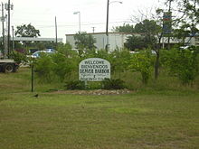
The Fifth Ward is a community of Houston, Texas, United States, derived from a historical political district (ward), about 2 miles (3.2 km) northeast of Downtown. Its boundaries are Buffalo Bayou on the south, Jensen Drive on the west, Collingsworth Rd on the north, and Lockwood Drive on the east.

<span class="mw-page-title-main">Sharpstown, Houston</span> Community in Houston, Texas

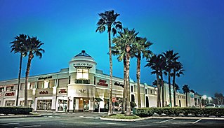
Sharpstown is a master-planned community in the Southwest Management District, Southwest Houston, Texas. It was one of the first communities to be built as a master-planned, automobile centered community and the first in Houston. Frank Sharp (1906–1993), the developer of the subdivision, made provisions not only for homes but also for schools, shopping and recreation areas. While this model has been duplicated countless times in the past fifty years, at the time it was quite revolutionary, attracting national media attention. The development was dedicated on March 13, 1955.

<span class="mw-page-title-main">Westbury, Houston</span>

Westbury is a neighborhood in the Brays Oaks district of Southwest Houston, Texas, United States. It is located east of Bob White Road, north of U.S. Highway 90 Alternate, and west of South Post Oak Road, adjacent to the Fondren Southwest and Meyerland neighborhoods, just west of the southwest corner of the 610 Loop.

<span class="mw-page-title-main">Second Ward, Houston</span>

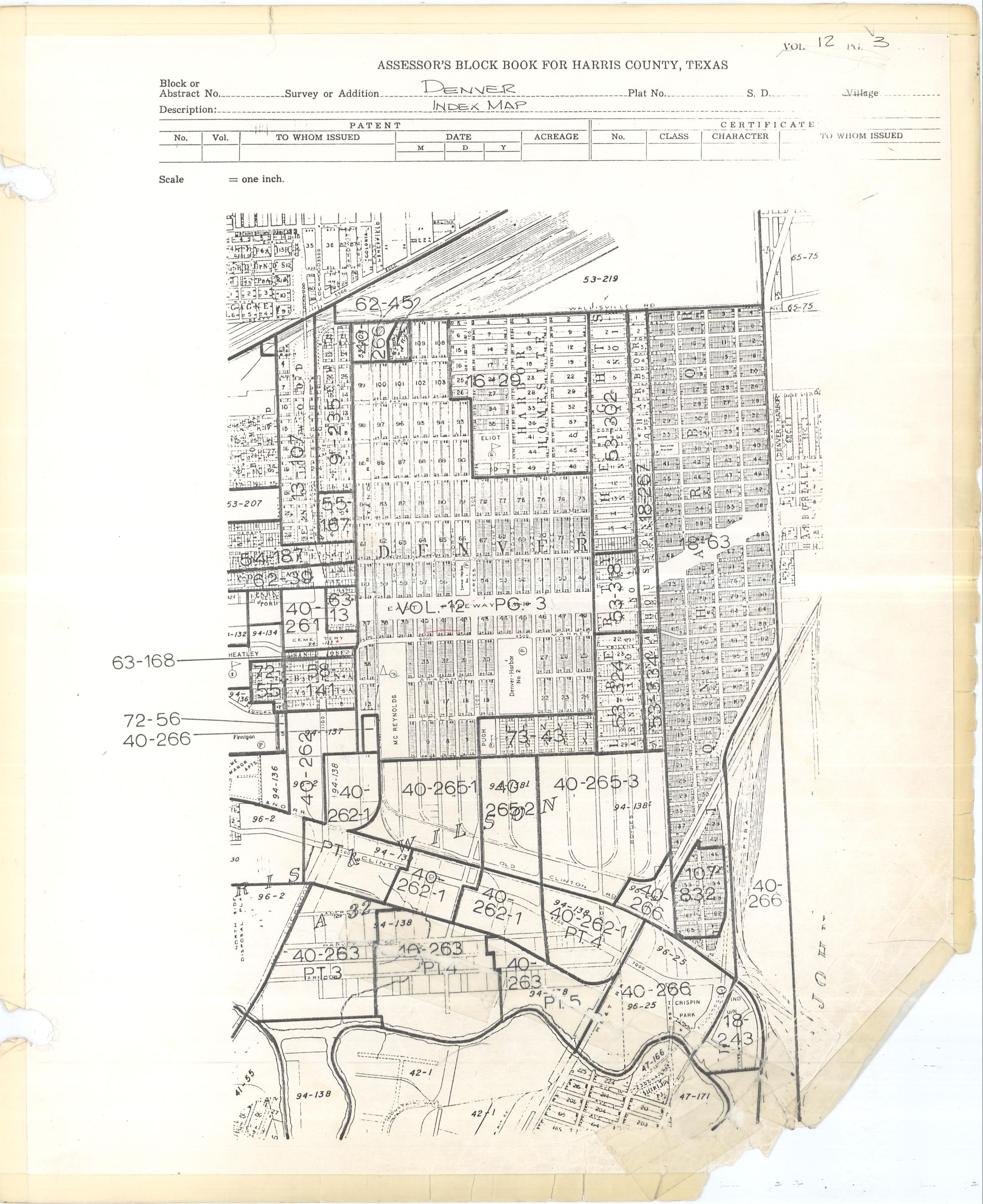
Second Ward is a historical political district ward in the East End community in Houston, Texas. It was one of the four original wards of the city in the nineteenth century. The community known as the Second Ward today is roughly bounded by Buffalo Bayou to the north, Lockwood Avenue to the east, and railroad tracks to the south and west, although the City of Houston's "Super Neighborhood" program includes a section east of Lockwood.

<span class="mw-page-title-main">Meyerland, Houston</span> Community in Houston, Texas

Meyerland is a community in southwest Houston, Texas, outside of the 610 Loop and inside Beltway 8. The neighborhood is named after the Meyer family, who bought and owned 6,000 acres (24 km2) of land in southwest Houston.

Houston Heights is a community in northwest-central Houston, Texas, United States. "The Heights" is often referred to colloquially to describe a larger collection of neighborhoods next to and including the actual Houston Heights. However, Houston Heights has its own history, distinct from Norhill and Woodland Heights.

<span class="mw-page-title-main">Braeswood Place, Houston</span>

Braeswood Place is a group of subdivisions in Harris County, Texas, United States. The vast majority of the land is in Houston while a small part is in Southside Place.

<span class="mw-page-title-main">Afton Oaks, Houston</span>

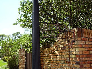
Afton Oaks is a deed-restricted "Inner Loop" upscale residential community of approximately 525 homes in Houston, Texas, United States. Afton Oaks is located inside Interstate 610 near the Galleria and Highland Village. The neighborhood is bounded on the north by Westheimer Road, on the east by Union Pacific railroad tracks, on the south by Interstate 69/U.S. Highway 59, and on the west by Interstate 610.

<span class="mw-page-title-main">Wheatley High School (Houston)</span> School

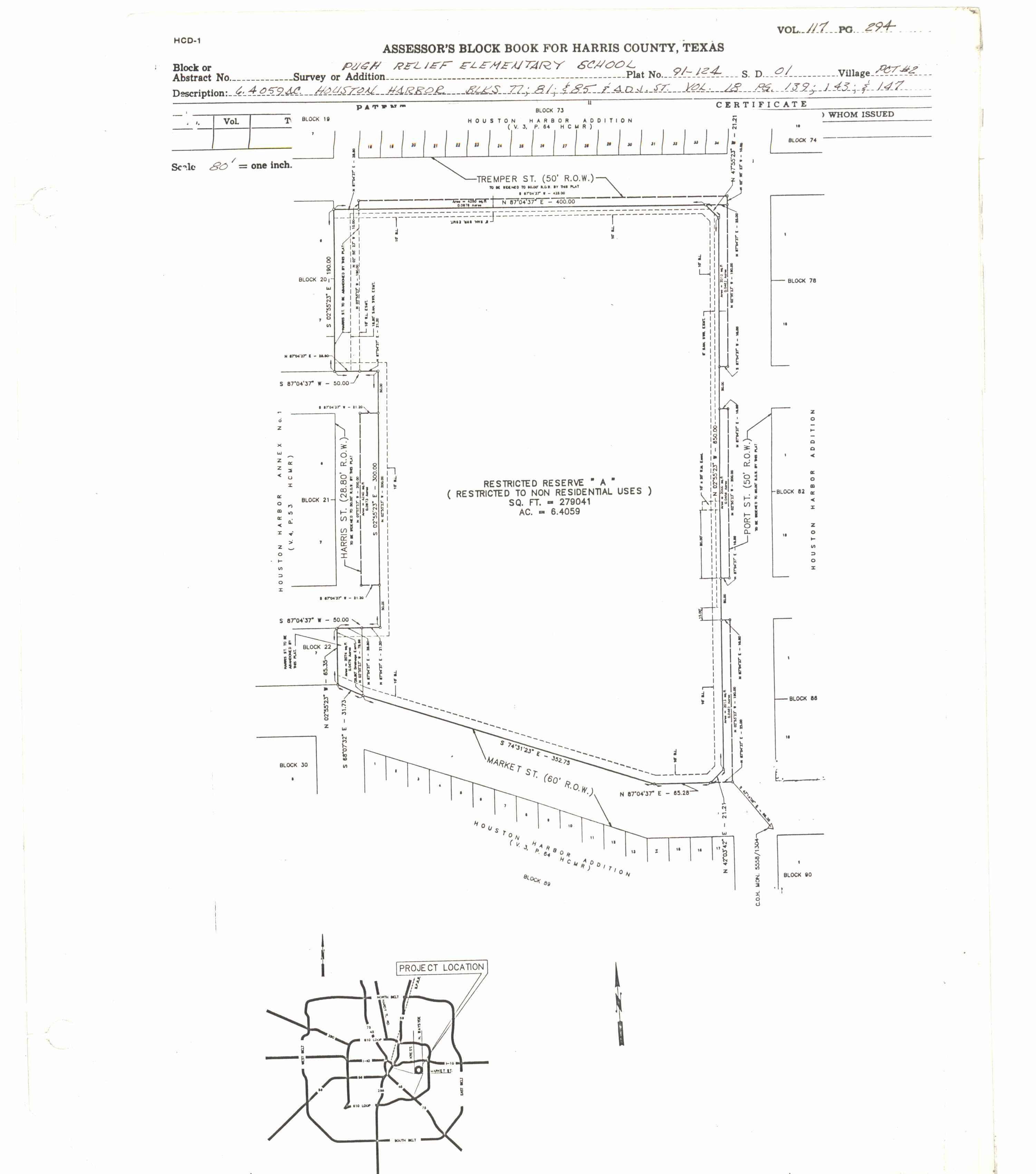
Phillis Wheatley High School is a secondary school located at 4801 Providence Street in Houston, Texas, United States with a ZIP code of 77020. Wheatley is a part of the Houston Independent School District. Wheatley, named after Phillis Wheatley, is located inside the 610 Loop in the Fifth Ward.

Pecan Park is a neighborhood in Houston, Texas.

<span class="mw-page-title-main">Willow Meadows, Houston</span>

Willow Meadows is a subdivision in Houston, Texas, United States.

<span class="mw-page-title-main">Willowbend, Houston</span>

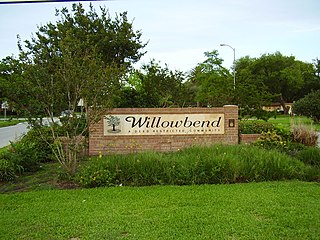
Willowbend is a neighborhood in near Southwest Houston, Texas.

Independence Heights is a community in Houston, Texas, bordered by 40th Street east of N. Main and 40th Street west of N. Main to the north, Yale Street to the west, the 610 Loop to the south, and Airline Drive to the east. The Super Neighborhood boundary created by the City of Houston is bordered by Tidwell to the north, Shepherd Drive to the west, the 610 Loop to the south, and Interstate 45 to the east.

Near Northside is a historic neighborhood located in Northside, Houston, Texas. Near Northside is primarily occupied by people of Hispanic descent.

Manchester is a community in southeastern Houston, Texas, United States.

<span class="mw-page-title-main">Harvard Elementary School (Texas)</span> Public primary school in Houston, Texas

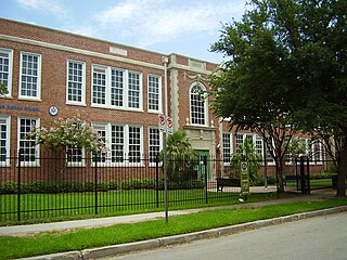
Harvard Elementary School is a public primary school in the Houston Heights neighborhood of Houston, Texas, United States. Harvard, a part of the Houston Independent School District, serves grades Pre-Kindergarten through 5.

Kashmere Gardens is a historically African-American neighborhood in the northern 610 Loop area in Houston, Texas, United States. A group of single-family houses, many of which have large lots, Kashmere Gardens is between an industrial area and a rail corridor.

Cottage Grove is a community in Houston, Texas.

<span class="mw-page-title-main">Westwood (subdivision), Houston</span>

Westwood is a residential subdivision in Southwest Houston, Texas. The subdivision is bounded by the 610 Loop, the Union Pacific railroad tracks, Stella Link Road, and Willowbend Boulevard. It has about 800 houses.

Sunset Heights is a neighborhood in northern Houston.

References

  1. 1 2 3 4 5 6 "80(R) HCR 81 - Introduced version - Bill Text". capitol.state.tx.us. Retrieved 2009-04-05.
  2. "Denver Harbor." Houston Hope Homes. Retrieved on May 2, 2009.
  3. "." Denver Harbor/Port Houston Super Neighborhood Community Health Assessment Report. City of Houston Department of Health and Human Services, Office of Surveillance and Public Health Preparedness.
  4. 1 2 Babineck, Mark, Alysha N. Hernandez, and the Austin Bureau. "A Houstonian has persuaded the state House to make his boyhood neighborhood an `official mythical town' / Podunk, Texas - not far away, really." Houston Chronicle . Thursday May 10, 2007. B1 MetFront. Retrieved on April 4, 2009.
  5. 1 2 3 4 Berryhill, Michael (April 17, 1997). "What's Wrong With Wheatley?". Houston Press. Archived from the original on July 21, 2021.
  6. Lee, Renée C. "Annexed Kingwood split on effects." Houston Chronicle . Sunday October 8, 2006. A21. Retrieved on July 6, 2011. Print version exclusively has the information cited; the information is not included in the online edition.
  7. 1 2 3 Babineck, Mark. '"Podunk" loses shot at mythic status.' Houston Chronicle . June 9, 2007. Retrieved on March 31, 2009.
  8. Woodard, Brad. "Denver Harbor homes take on water." KHOU-TV . Thursday August 16, 2006. Retrieved on April 4, 2009.
  9. Cerota, Andy. "Residents fighting crime with help." KTRK-TV . April 17, 2008. Retrieved on January 22, 2010.
  10. 1 2 3 "Denver Harbor Multi-Service Center" . Retrieved December 25, 2023.
  11. "City of Houston, District H" (PDF). Retrieved December 25, 2023.
  12. "HFD Fire Station No. 27". Archived from the original on November 14, 2013. Retrieved December 25, 2023.
  13. "DENVER HARBOR — Post Office™". tools.usps.com. Retrieved 2023-12-26.
  14. "Postal Service considers shutting 9 Houston branches". Houston Chronicle. 2011-07-26. Retrieved 2023-12-26.
  15. RYAN, CINDY HORSWELL and MEGAN (2011-07-26). "South Texas post office closures 'heart breaking' for many". Chron. Retrieved 2023-12-26.
  16. 1 2 3 "Council District H Park Inventory" (PDF). Retrieved December 25, 2023.
  17. "Trustees / Trustees". www.houstonisd.org. Retrieved 2023-12-26.
  18. 1 2 "2023 - 2024 TRUSTEE DISTRICTS" (PDF). www.houstonisd.org. Retrieved December 25, 2023.
  19. Harris County Block Book Maps, Volume 12, Page 3. "Denver Index Map." PDF and JPG.
  20. Refer to the Denver Index Map. Also, Harris County Block Book Maps Volume 18, Page 99. "Houston Harbor Block 37". PDF and JPG. Also Volume 18, Page 269. "Houston Harbor Annex Blocks 9-12." PDF and JPG.
  21. Harris County Block Book Maps Volume 117, Page 294. "Pugh Relief Elementary School." PDF and JPG. Bounded by Market Street, Port Street, Tremper Street, and Harris Street, meaning it is Raul C. Martinez Elementary School.
    See also Volume 18. Pages 139, 143, and 147, which show respectively the following blocks for Houston Harbor:
    • 77: PDF and JPG - Block bounded by Tremper, Amarillo, Harris, and Port - Volume 112, Page 294
    • 81: PDF and JPG - Block bounded by Dallas, Amarillo, Harris, and Port - Volume 112, Page 294
    • 85: PDF and JPG - Block bounded by Harris, Market, Port, and Dallas
  22. "McReynolds Middle Attendance Zone Archived 2007-09-30 at the Wayback Machine ." Houston Independent School District . Retrieved on April 4, 2009.
  23. "Wheatley High School Attendance Zone Archived 2007-09-30 at the Wayback Machine ." Houston Independent School District . Retrieved on April 4, 2009.
  24. Harris County Block Book Maps Volume 117, Page 573. "McReynolds Middle School Subd." PDF and JPG.
    See also Volume 12. Pages 12, 13, 16, 17, 36, and 37, which show respectively the following blocks for Denver Addition:
  25. 1 2 "School Histories: the Stories Behind the Names Archived July 10, 2011, at the Wayback Machine ." Houston Independent School District . Retrieved on September 24, 2008.
  26. "Resurrection School Archived 2016-03-04 at the Wayback Machine ." Roman Catholic Archdiocese of Galveston-Houston . Retrieved on September 8, 2012.
  27. Harris County Block Book Maps Volume 12, Page 28. "Denver Addition Block 26" PDF and JPG.
  28. "About". Resurrection School. Retrieved 2020-06-06. Resurrection Catholic School is located in Denver Harbor[...]
  29. Rhor, Monica (2012-08-15). "Houston Catholic school enrollment strong and growing". Houston Chronicle . Retrieved 2020-06-06. 215 students - an increase of about 7 percent from last year.[...]Just 10 years ago, the school had 137 students;[...] - The source states Resurrection School is in the East End, but it is in Denver Harbor, which is not in the East End district.
  30. "Single Member District VIII Map with precincts | Houston Community College (HCC) | We are Houston's Community College". www.hccs.edu. Retrieved 2023-12-26.
  31. "Tuttle Neighborhood Library Archived 2009-04-29 at the Wayback Machine ." Houston Public Library . Retrieved on April 4, 2009.
  32. Rodriguez, Lori. "Ben Reyes: His old friends hardly know him anymore." Houston Chronicle . June 2, 1991. A1.

Further reading

29°46′30″N95°18′00″W / 29.775°N 95.300°W / 29.775; -95.300