
The Houston Museum District is an association of 19 museums, galleries, cultural centers and community organizations located in Houston, Texas, dedicated to promoting art, science, history and culture.

Montrose is an area located in west-central Houston, Texas, United States and is one of the city's major cultural areas. Montrose is a 7.5 square miles (19 km2) area roughly bounded by Interstate 69/U.S. Highway 59 to the south, Allen Parkway to the north, South Shepherd Drive to the west, and Taft to Fairview to Bagby to Highway 59 to Main to the east. Montrose neighborhoods include Cherryhurst, Courtlandt Place, Hyde Park, Montrose, Vermont Commons, North and East Montrose, Mandell Place and Winlow Place. Montrose is also less well known by the moniker Neartown, encompassing Superneighborhood #24.
Bob Lanier Middle School, formerly Sidney Lanier Junior High School/Middle School, is a middle school in Houston, Texas, United States, with a ZIP code of 77098. Lanier, a school of the Houston Independent School District (HISD), handles grades 6 through 8. Named after former mayor of Houston Bob Lanier, the school is located in Neartown and near Montrose and has both neighborhood non-magnet and Vanguard/IBMYP gifted/talented programs. Lanier's neighborhood program serves Montrose, Afton Oaks, Boulevard Oaks, River Oaks, Southampton, and other communities.
Midtown is a central neighborhood of Houston, located west-southwest of Downtown. Separated from Downtown by an elevated section of Interstate 45, Midtown is characterized by a continuation of Downtown's square grid street plan, anchored by Main Street and the METRORail Red Line. Midtown is bordered by Neartown (Montrose) to the west, the Museum District to the south, and Interstate 69 to the east. Midtown's 325 blocks cover 1.24 square miles (3.2 km2) and contained an estimated population of nearly 8,600 in 2015.
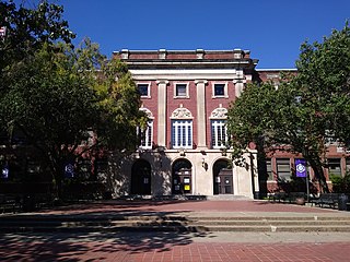
Lamar High School is a comprehensive public secondary school located in Houston, Texas, United States. It is a part of the Houston Independent School District (HISD). Lamar High School, was established in 1936 in memory of Mirabeau B. Lamar (1798–1859), a leader in the Texas Revolution and the second President of the Republic of Texas. Lamar has a four-year program, serving grades 9 through 12.

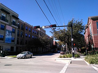
Upper Kirby is a commercial district in Houston, Texas, United States. It is named after Kirby Drive, so indirectly takes its name from John Henry Kirby.

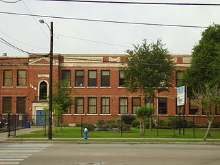
Edgar Allan Poe Elementary School is a primary school located at 5100 Hazard Street in Houston, Texas, United States. A part of the Houston Independent School District (HISD), the school, which was built during the 1920s, is located in the Chevy Chase subdivision of the Boulevard Oaks neighborhood west of Rice University. The school, a National Register of Historic Places (NRHP) historic district contributing property of Boulevard Oaks, was named after Edgar Allan Poe.

Northside High School, formerly Jefferson Davis High School, is a secondary school located at 1101 Quitman in the Near Northside neighborhood of Northside, Houston, Texas with a ZIP code of 77009. The school was previously named after Jefferson Davis, the only president of the Confederate States of America.

Edgar Gregory-Abraham Lincoln Education Center (GLEC) is a K-8 school located at 1101 Taft in the Fourth Ward area of Houston, Texas, United States. Gregory-Lincoln is a part of the Houston Independent School District (HISD) and has a fine arts magnet program that takes students in both the elementary and middle school levels. Originally built in 1966 as Lincoln Junior and Senior High School, it later operated as Lincoln Junior High School until Gregory Elementary School merged into it in 1980, forming Gregory-Lincoln. The school moved into its current building in 2008; the rebuilding was delayed due to concerns that U.S. Civil War-era graveyards would be disturbed by the rebuilding process.

Montrose is a neighborhood located in west-central Houston, Texas, United States. Montrose is a 7.5-square-mile (19 km2) area roughly bounded by Interstate 69/U.S. Highway 59 to the south, Allen Parkway to the north, South Shepherd Drive to the west, and Taft to Fairview to Bagby to Highway 59 to Main to the east. The area is also referred to as Neartown or Neartown / Montrose.
James D. Ryan Middle School was a secondary school located in Houston, Texas, United States. The Baylor College of Medicine Academy at Ryan, a magnet middle school, now occupies the campus.

Shenandoah is a subdivision in Houston, Texas, United States.

Southeast Houston is an area in Houston, Texas, United States. The Greater Southeast Management District (GSMD) manages a district using the name Southeast houston. Communities within the district include the Third Ward, Texas Medical Center, Riverside Terrace, University Oaks, and Washington Terrace.

The Westmoreland Historic District is a neighborhood in Neartown Houston, Texas. It is west of Spur 527, between Westheimer Road and West Alabama Street.

William H. Wharton K-8 Dual Language Academy, formerly William Wharton Elementary School, is a public school in the Neartown area of Houston, Texas and part of the Houston Independent School District. Also known as the Wharton Dual Language Academy, the school serves gifted and talented students in the Language Magnet program from Pre-K through 8th grade.
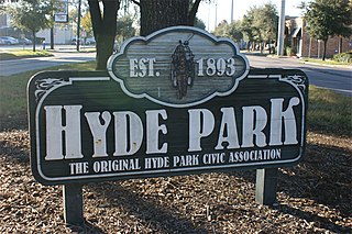
Hyde Park is a historic community located in the Montrose neighborhood of Houston, Texas. Its southeast boundary is the intersection Montrose Boulevard and Westheimer. The neighborhood was established in the late 1800s on the summer farm of the second President of the Republic of Texas, Mirabeau Lamar. In the 1970s, Hyde Park became a central part of the Gay Rights Movement in Houston. Like much of Montrose, the neighborhood is now experiencing significant gentrification, and is home to an abundance of restaurants, including Mexican, Italian, Greek, American, Lebanese, coffee houses, and numerous bars.

Ella J. Baker Montessori School, formerly Woodrow Wilson Montessori School and Woodrow Wilson Elementary School, is a public K-8 Montessori school in the Cherryhurst Addition subdivision in the Neartown area of Houston, Texas. A part of the Houston Independent School District (HISD), Baker serves as the neighborhood elementary school for a section of Neartown, including a portion of Montrose. It also serves as a magnet school for all of HISD's territory. As of 2014 it is one of three public Montessori programs in Houston. It was the first HISD school to use the Montessori style for all students, as well as housing HISD's first Montessori middle school program. It was formerly named after President of the United States Woodrow Wilson and had its name changed in 2021 due to racist actions taken by the president; it is now named after civil rights activist Ella J. Baker.
Houston Housing Authority (HHA), formerly Housing Authority of the City of Houston (HACH), is the public housing authority in Houston, Texas.
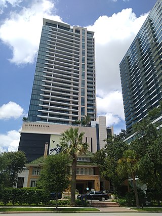
La Colombe d'Or is a hotel and residential complex in Neartown, Houston. It includes an original building in a Beaux-Arts style, a skyscraper with 34 stories, and a bungalow property.

