
The Northside is a district of Houston, Texas, United States. It is within the Greater Northside Management District.
The Northside is a district of Houston, Texas, United States. It is within the Greater Northside Management District.
House Bill 3634, authored by state representative Jessica Farrar and sponsored in the Texas Senate by Mario Gallegos, created the management district. The bill became the Chapter 3812 Texas Special Districts Local Laws Code and the district began operation in August 2006. [1]
Jim McIngvale, the owner of Gallery Furniture, a furniture business with a location in the Northside, refused to pay $48,000 in taxes to the management district that were assessed from 2005 to 2007; he paid taxes to the district in 2008. McIngvale said that the management district does not do enough to maintain the area; the business owner described the management district's taxation policies as "taxation without representation." The district sued McIngvale to try to force him to pay the taxes. McIngvale said that he is willing to dispute the charges in court. During that month a fire destroyed his north Houston store's warehouse. [2]

The management district is headquartered at 6219 Irvington Boulevard. [3]
The Houston Fire Department operates stations in the district. [4] Stations inside include two in Fire District 19, Station 9 Northside and Station 12 Moody Park. In addition Station 15 Heights of Fire District 6 and Station 30 Lindale Park of Fire District 31 are in the district. [5]
The Harris County Department of Education is headquartered in Northside in the Ronald W. Reagan Building. [6]
The Harris Health System (formerly Harris County Hospital District) Casa de Amigos ("House of Friends") Health Center is in the Near Northside. It opened on August 21, 1970 in the near Northside. [7] The hospital system designated the Casa de Amigos clinic for the ZIP code 77009 and the Aldine Health Center for the ZIP code 77022. The designated public hospitals for these two ZIP codes are Ben Taub General Hospital in the Texas Medical Center and the Lyndon B. Johnson Hospital in northeast Houston, respectively. [8]
The City of Houston Health Department operates two clinics in the Northside: Nueva Casa de Amigos ("New House of Friends"), [9] and Northside. [10]
The Houston Housing Authority (HHA) operates the following public housing complexes in Northside: Fulton Village, [11] Heatherbrook Apartments, [12] Irvinton Village, [13] and Oxford Place. [14]

In 2009, Saint Arnold's Brewing relocated to the Northside area at 2000 Lyons, purchasing a building that was formerly a food service facility for the Houston Independent School District. [4] [16] Shipley Do-Nuts has its headquarters in the Northside. [4] [17]
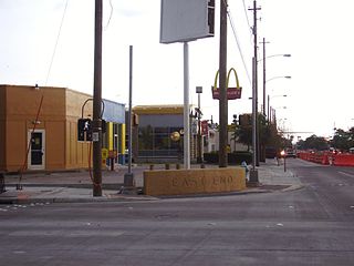
The "Fulton Corridor," a stretch of Fulton Street within the district, is a major commercial avenue. By 2010 many major chains such as Auto Zone, Family Dollar, Payless ShoeSource, Rent A Center, and Walgreens relocated outlets to the strip. [18]
FedEx used to operate a freight facility in the area. As of 2010 the former freight facility land will house a 144-unit apartment complex with a clubhouse and a pool. [18]
Metropolitan Transit Authority of Harris County, Texas (METRO) operates bus services in the Northside. The METRO Northline Transit Center opened at the northwest corner of Northline Mall on Saturday October 27, 2001. The center, covered and lighted, is the 15th transit center established by METRO. [19] The center, with a price tag of $1 million, has four bus bays, an information kiosk, newspaper vending machines, benches, a covered platform, and bicycle racks. [20] When the center opened, four bus routes served it. [21] It became the northern terminus of the METRORail light rail system's Red Line on December 21, 2013; the line runs on Fulton Street and also stops at seven additional stations. [22]
Coach USA, in partnership with Greyhound Lines, operates the Crosstimbers station at 4001 North Freeway. [23]

Most residents are within the Houston Independent School District. [4] Two HISD zoned high schools, Northside (formerly Jefferson Davis) and Sam Houston, are in the Northside. [24] [25] Zoned high schools serving additional portions of the Northside include Heights (formerly John H. Reagan), [26] Kashmere, [27] and Washington. [28] North Houston Early College High School is an optional school in the Northside. [29] For a period Mickey Leland College Preparatory Academy for Young Men resided in the former Crawford Elementary School, in both the Fifth Ward and Northside. [30] [31] [32] [33]
Some sections are within the Aldine Independent School District. Residents of AISD in the Northside are zoned to MacArthur High School in unincorporated Harris County. [34]
In 2011, YES Prep opened YES Prep Northside, a state charter school currently serving 6-12th grade. [4] [35] In addition George I. Sanchez Charter School North is also in Northside. [36] [37] Juan B. Galaviz Charter School and Benji's Academy were previously in Northside. [38] [39]

Houston Public Library operates public libraries in the Northside. The Carnegie Neighborhood Library and the Moody Neighborhood Library are within the district boundaries. [40] [41] The Dixon Neighborhood Library is adjacent to the district. [42]

Houston Community College operates the Northline Campus of the Northeast College. [43]
The University of Houston–Downtown (UHD) is located within proximity of the community. [44] [45]

Westbury is a neighborhood in the Brays Oaks district of Southwest Houston, Texas, United States. It is located east of Bob White Road, north of U.S. Highway 90 Alternate, and west of South Post Oak Road, adjacent to the Fondren Southwest and Meyerland neighborhoods, just west of the southwest corner of the 610 Loop.
Harrisburg is a community that is now located within the city of Houston, Texas, United States.

James Franklin McIngvale, also known as "Mattress Mack", is a businessman from Houston, Texas. He is known for owning and operating the Gallery Furniture retail chain.

Upper Kirby is a commercial district in Houston, Texas, United States. It is named after Kirby Drive, so indirectly takes its name from John Henry Kirby.

Houston Heights is a community in northwest-central Houston, Texas, United States. "The Heights" is often referred to colloquially to describe a larger collection of neighborhoods next to and including the actual Houston Heights. However, Houston Heights has its own history, distinct from Norhill and Woodland Heights.

Northside High School, formerly Jefferson Davis High School, is a secondary school located at 1101 Quitman in the Near Northside neighborhood of Northside, Houston, Texas with a ZIP code of 77009. The school was previously named after Jefferson Davis, the only president of the Confederate States of America.

The Woodland Heights neighborhood is one of the oldest and most historic in Houston, Texas. It encompasses approximately 2000 homes in the 77009 ZIP code and is bounded on the north by Pecore Street, on the west by Studewood Street, on the east by I-45, and on the south by I-10.
Independence Heights is a community in Houston, Texas, bordered by 40th Street east of N. Main and 40th Street west of N. Main to the north, Yale Street to the west, the 610 Loop to the south, and Airline Drive to the east. The Super Neighborhood boundary created by the City of Houston is bordered by Tidwell to the north, Shepherd Drive to the west, the 610 Loop to the south, and Interstate 45 to the east.
Near Northside is a historic neighborhood located in Northside, Houston, Texas. Near Northside is primarily occupied by people of Hispanic descent.

Lindale Park is a neighborhood in Houston, Texas.
East End Houston, managed by the East End District (EED), is a district in eastern Houston, Texas, United States, located between the eastern edge of downtown to the Port of Houston and South to Hobby Airport. The District is home to Houston's early history and industry and is the site of Harrisburg, the seat of government for the Republic of Texas in 1836. East End Houston consists of many different ethnic groups, including Hispanic, Asian, White, and African American. Latinos make up more than half of the 100,512 residents, The area includes two of Houston's oldest Hispanic neighborhoods, Magnolia Park and Second Ward.
Greater Katy Area is the term often used to refer to a suburban region on the west side of the Greater Houston metropolitan area roughly corresponding to the boundaries of the Katy Independent School District. Many people and businesses in this area have a Katy address, but not part of the city of Katy. This area includes the suburbs that surround the Katy city limits west to Pederson road, roughly east to State Highway 6, north to FM 529 and south to FM 1093/ Westpark Tollway Parkway. While these boundaries are not exact, it gives a rough outline of what most people consider Greater Katy. Most of Greater Katy is to the east of the city of Katy toward Houston and includes surrounding suburban areas and unincorporated areas that are not in the Houston city limits. The region includes parts of Harris County, Fort Bend County, and Waller County much as the City of Katy does. Greater Katy is one of the fastest growing portions of the Houston metropolitan area and the state of Texas as a whole.

Southwest Management District, formerly Greater Sharpstown Management District, is a district in Houston, Texas, United States. The district is split into 6 neighborhoods: Sharpstown, Chinatown, Mahatma Gandhi District/Little India, Westwood, Harwin, and University.

The Westmoreland Historic District is a neighborhood in Neartown Houston, Texas. It is west of Spur 527, between Westheimer Road and West Alabama Street.
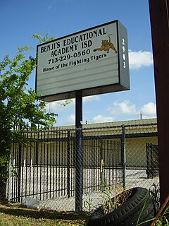
Benji's Special Educational Academy Independent School District was a state charter school with two campuses in the Northside district of Houston, Texas, near the Fifth Ward. The school covered grades Pre-Kindergarten 4-12. The school initially defied an order to close from the Texas Education Agency (TEA). In 2011 it merged with Leader's Academy High School for Business and Academic Success into Victory Preparatory Academy.
Victory Preparatory Academy or Victory Prep (VPREP) was a charter school in Houston, Texas that had two campuses: one in the city's south, Victory Preparatory Academy South; and a northern campus, Victory Preparatory Academy North. The system all together served grades K-12 and was operated by the nonprofit organization Management Accountability Corp. It closed in 2018.

Harris County Department of Education (HCDE) is an agency of the government of Harris County, Texas, in the Houston metropolitan area; it is headquartered in Northside district in Houston. As of 2018 it handles the enrollment of around 200 students with special needs.
Houston Housing Authority (HHA), formerly Housing Authority of the City of Houston (HACH), is the public housing authority in Houston, Texas.
La Nueva Casa de Amigos Health Center 1809 North Main Street Houston, Texas 77009
Northside Health Center 8504 Schuller Road Houston, Texas 77093
AAMA – Sanchez Charter School 6001 Gulf Freeway, Building E Houston, TX 77023[...]AAMA – Sanchez Charter School-North 215 Rittenhouse St. Houston, TX 77076
