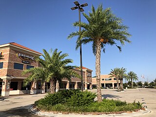
Katy is a city in the U.S. state of Texas within the Greater Katy area, itself forming the western part of the Greater Houston metropolitan area. Homes and businesses may have Katy postal addresses without being in the City of Katy. The city of Katy is approximately centered at the tripoint of Harris, Fort Bend, and Waller counties. Katy had a population of 21,894 at the 2020 U.S. census, up from 14,102 in 2010.

Spring Branch Independent School District is a school district headquartered in Hedwig Village, Texas, United States in Greater Houston. The district serves portions of western Houston, including most of Spring Branch. It also serves several small municipalities known as the Memorial Villages in its jurisdiction, such as Hedwig Village and Spring Valley Village. A majority of the district lies within Houston city limits.
The Memorial area of Houston, Texas is located west of Downtown, northwest of Uptown, and south of Spring Branch. The Memorial Super Neighborhood, as defined by the City of Houston, is bounded by Buffalo Bayou to the south, Barker Reservoir to the west, the Katy Freeway to the north, and the Memorial Villages, a contiguous group of independent municipalities, to the east.
The Katy Independent School District (KISD) is a public school district based in Katy, Texas, United States with an enrollment of over 85,700 students. As of August 2009, the district was rated as "Recognized" by the Texas Education Agency.
Cypress is an unincorporated community in Harris County, Texas, United States, located completely inside the extraterritorial jurisdiction of the City of Houston. The Cypress area is located along U.S. Highway 290 is twenty-four miles (35 km) northwest of Downtown Houston. The Cypress urban cluster ranks 50th in the top 100 highest-income urban areas in the United States.

Mayde Creek High School (MCHS) is a public high school located on Groschke Road in unincorporated Harris County, Texas, and is part of the Katy Independent School District. Mayde Creek serves the portions of the city of Houston located in Katy ISD, including Addicks. Mayde Creek also serves many unincorporated communities in Harris County.
Humble Independent School District is a school district located in Humble, Texas, United States. It serves the city of Humble, small portions of the city of Houston, and portions of unincorporated Harris County. A small section of the district extends into Montgomery County. For the 2018–2019 school year, the district enrolled 43,553 students.
Bridgeland Community is an 11,401-acre (46.14 km2) master-planned community under construction in unincorporated Harris County, Texas to the northwest of Houston between U.S. Highway 290 and Interstate 10. Bisecting Bridgeland is Segment E of the Grand Parkway, a 15.2-mile thoroughfare that broke ground in 2011 and opened in December 2013.

The Addicks Reservoir and Addicks Dam in conjunction with the Barker Reservoir prevent downstream flooding of Buffalo Bayou in the City of Houston, Texas. Both reservoirs were authorized under the Rivers and Harbors Act of June 20, 1938, which was modified by the Flood Control Acts of August 11, 1938; September 3, 1954; and October 27, 1965. The U.S. Army Corps of Engineers completed construction of Addicks Dam and the outlet facility in 1948.

The Energy Corridor is a business district in Houston, Texas, located on the west side of the metropolitan area between Beltway 8 and the Grand Parkway. The district straddles a 7-mile (11 km) stretch of Interstate 10 from Kirkwood Road westward to Barker Cypress Road and extends south along Eldridge Parkway to Briar Forest Drive. Parts of the district overlap with the Memorial area of Houston. The district is located north of Westchase, another major business district of Houston, and east of Greater Katy.
Greater Katy Area is the term often used to refer to a suburban region on the west side of the Greater Houston metropolitan area roughly corresponding to the boundaries of the Katy Independent School District. Many people and businesses in this area have a Katy address, but not part of the city of Katy. This area includes the suburbs that surround the Katy city limits west to Pederson road, roughly east to State Highway 6, north to FM 529, and south to FM 1093/ Westpark Tollway Parkway. While these boundaries are not exact, it gives a rough outline of what most people consider Greater Katy. Most of Greater Katy is to the east of the city of Katy toward Houston and includes surrounding suburban areas and unincorporated areas that are not in the Houston city limits. The region includes parts of Harris County, Fort Bend County, and Waller County much as the City of Katy does. Greater Katy is one of the fastest-growing portions of the Houston metropolitan area and the state of Texas as a whole.
Satsuma is an area in northern unincorporated Harris County, Texas, United States.
Fairbanks is a community along U.S. Highway 290 and the Southern Pacific Railroad in Western Houston, Texas, United States. At one point it was a distinct unincorporated area within Harris County.
Copperfield is a series of master-planned subdivisions in unincorporated northwest Harris County, Texas, United States. The community, developed by Friendswood Development Company, has 1,800 acres (7.3 km2) of land.

Barker Reservoir is a flood control structure in Houston, Texas which prevents downstream flooding of Buffalo Bayou, the city's principal river. The reservoir operates in conjunction with Addicks Reservoir to the northeast, which impounds Mayde and Bear Creeks, two tributaries of the Buffalo. Both reservoirs were authorized under the Rivers and Harbors Act of June 20, 1938, which were modified by the Flood Control Acts of August 11, 1938; September 3, 1954; and October 27, 1965.
Howellville or Howell is an unincorporated community in Harris County, Texas, United States, which has been absorbed by Greater Houston. The site is located at the intersection of Alief Clodine Road and Sugar Land Howell Road on the west side of Houston, approximately halfway between the original settlements of Clodine and Alief. There are no road signs identifying the place. The community began as a stop on a railroad line that no longer exists.

The Cypress-Fairbanks Independent School District is an independent school district with its headquarters in northwest unincorporated Harris County, Texas, United States. Cy-Fair ISD is the largest Recognized school district in the state of Texas with 75 out of 78 campuses receiving an 'Exemplary' or 'Recognized' rating by the Texas Education Agency in 2010.
Lakes on Eldridge is an unincorporated area in northwest Harris County, Texas, in Greater Houston. There is an adjacent subdivision, Lakes on Eldridge North.

