Robindell, Houston

Last updated

Robindell is a subdivision in Southwest Houston, Texas. [1]

Contents

History

Robert Kuldell developed the community in the 1950s on 110 acres (45 ha) of farmland that belonged to his family. The neighborhood was originally targeted at former members of the United States Armed Forces. Robindell was developed before Meyerland, Sharpstown, and Westbury were. [2]

In 1997 the City of Houston added Robindell to a neighborhood restoration program. [3]

In 2009, Houston real estate blog website "Swamplot" nominated Robindell as Houston's Most Underappreciated Neighborhood. Similarly in 2010, the Houston Press nominated Robindell as one of Houston's Most Underrated Neighborhoods. [4]

In 2014, Robindell was awarded 2nd place for "Neighborhood of the Year" by Swamplot.

Cityscape

In 2010, when comparing and contrasting Robindell to Bellaire and Meyerland, Richard Connelly of the Houston Press said that Robindell, like the other two neighborhoods, has trees, but that "instead of McMansions it's been able to keep its older homes from being uprooted." [4] Connelly added that in Robindell, like the other "hidden neighborhoods" on the list, "you don't have to travel far to find trouble, but it's worth the occasional siren going by in the night." [4]

The subdivision has 610 houses as of 1996, with sizes ranging from 1,100 square feet (100 m2) to 1,500 square feet (140 m2). As of that year the median price was $56,590. As of 1996 the older houses, closer to Beechnut Street, had prices beginning at $50,000 ($81508.59 in current money). As of the same year larger houses, closer to North Braeswood Boulevard, had prices beginning at $100,000 ($163017.19 in current money). [2]

As of 1996 housing prices are lower in Robindell than in Meyerland and Maplewood because the Robindell houses are smaller and because Robindell is not zoned to Bellaire High School. [2]

When the houses were first built, customers met with homebuilders and determined which style the house would use. This led to a variety in the housing architecture. Many of the homes are of the mid-century ranch style. Katherine Feser of the Houston Chronicle said that all of the houses had "quality workmanship and materials." [2]

Transportation

The Metropolitan Transit Authority of Harris County (METRO) operates public transportation services.

Around 1988 METRO proposed having Beechnut Street widened. Residents of Robindell, Meyerland, and Maplewood appeared before the METRO board and protested the plans, stating that they would result in increased traffic. METRO dropped the plans. [5]

Government and infrastructure

Katherine Feser of the Houston Chronicle said that Robindell has always had an active civic club. [2]

Education

The Houston Independent School District operates public schools. [6]

Part of Robindell is zoned to McNamara Elementary School, and part is zoned to Herod Elementary School. [7] [8] Part of Robindell is zoned to Sugar Grove Middle School, [9] and part is zoned to Fondren Middle School. [10] All of the community is zoned to Sharpstown High School. [11]

Previously part of the subdivision was zoned to Sharpstown Middle School. [2]

Media

The Bellaire Texan, which served the Robindell community in the mid-20th Century, [12] was headquartered in Bellaire and published by the Texan Publishing Corporation. [13] By 1975 it became known as the Bellaire & Southwestern Texan and was published by the Preston Publishing Company. It was then headquartered in Houston. [14]

Related Research Articles

Chinatown, Houston Neighborhood of Houston in Harris County, Texas, United States

Chinatown is a community in Southwest Houston, Texas, United States.

Bellaire High School (Texas) Public secondary school in Bellaire, Texas, United States

Bellaire High School is a comprehensive, public secondary school in Bellaire, Texas. Part of the Houston Independent School District, it serves the incorporated city of Bellaire, the Houston community of Meyerland, and other adjacent Houston neighborhoods. It has a racially and socioeconomically diverse student body.

Bob Lanier Middle School Public school (us) school

Bob Lanier Middle School, formerly Sidney Lanier Junior High School/Middle School, is a middle school in Houston, Texas, United States, with a ZIP code of 77098. Lanier, a school of the Houston Independent School District (HISD), handles grades 6 through 8. Named after former Mayor of Houston Bob Lanier, the school is located in Neartown and near Montrose and has both neighborhood non-magnet and Vanguard/IBMYP gifted/talented programs. Lanier's neighborhood program serves Montrose, Afton Oaks, Boulevard Oaks, River Oaks, Southampton, and other communities.

Sharpstown, Houston

Sharpstown is a master-planned community in the Southwest Management District, Southwest Houston, Texas It was one of the first communities to be built as a master-planned, automobile centered community and the first in Houston. Frank Sharp (1906–1993), the developer of the subdivision, made provisions not only for homes but also for schools, shopping and recreation areas. While this model has been duplicated countless times in the past fifty years, at the time it was quite revolutionary, attracting national media attention. The development was dedicated on March 13, 1955.

Westbury, Houston

Westbury is a neighborhood in the Brays Oaks district of Southwest Houston, Texas, United States. It is located east of Bob White Road, north of U.S. Highway 90 Alternate, and west of South Post Oak Road, adjacent to the Fondren Southwest and Meyerland neighborhoods, just west of the southwest corner of the 610 Loop.

Lamar High School (Houston) American public high school

Lamar High School is a comprehensive public secondary school located in Houston, Texas, United States. It is a part of the Houston Independent School District (HISD). Lamar High School, was established in 1936 in memory of Mirabeau B. Lamar (1798–1859), a leader in the Texas Revolution and the second President of the Republic of Texas. Lamar has a four-year program, serving grades 9 through 12.

Westbury High School (Houston) High school in Brays Oaks, Texas

Westbury High School is a secondary school located in the Brays Oaks Management District, of Southwest Houston, Texas, near the Westbury neighborhood. It has grades 9 through 12, and is part of the Houston Independent School District. As of 2015 the principal is Susan Monaghan.

Meyerland, Houston

Meyerland is a 6,000-acre (9 sq mi) community in southwest Houston, Texas, outside of the 610 Loop and inside Beltway 8. The neighborhood is named after the Meyer family, who bought and owned 6,000 acres (24 km²) of land in southwest Houston.

Braeswood Place, Houston

Braeswood Place is a group of subdivisions in Harris County, Texas, United States. The vast majority of the land is in Houston while a small part is in Southside Place.

Afton Oaks, Houston

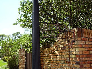
Afton Oaks is a deed-restricted "Inner Loop" upscale residential community of approximately 525 homes in Houston, Texas, United States. Afton Oaks is located inside Interstate 610 near the Galleria and Highland Village. The neighborhood is bounded on the north by Westheimer Road, on the east by Union Pacific railroad tracks, on the south by Interstate 69/U.S. Highway 59, and on the west by Interstate 610.

Pin Oak Middle School School in Bellaire, Texas, United States

Pin Oak Middle School is a secondary school that is located in Bellaire, Texas, United States. Pin Oak, which serves grades 6 through 8, is a part of the Houston Independent School District. It is located near the intersection of the 610 Loop and U.S. Route 59. From 2002 to 2004 Suzanne Sutherland was principal. From 2004 to 2010 Michael McDonough was Principal. From December 2009 to July 2010 Amy Simson was the interim principal. From 2011 to 2015 Susan Monaghan was principal.

Maplewood South–North, Houston

Maplewood South/North is a group of subdivisions in Houston, Texas.

Willow Meadows, Houston

Willow Meadows is a subdivision in Houston, Texas, United States.

Maplewood, Houston

Maplewood is a community in Houston, Texas located outside the 610 Loop, southwest of Downtown Houston. It consists of 524 houses. They are one-story and two-story houses, as two stories is the limit allowed by the subdivision. The oldest houses were built in the early 1950s. Maplewood is located along Beechnut, Hillcroft, and Renwick.

Braeburn, Houston

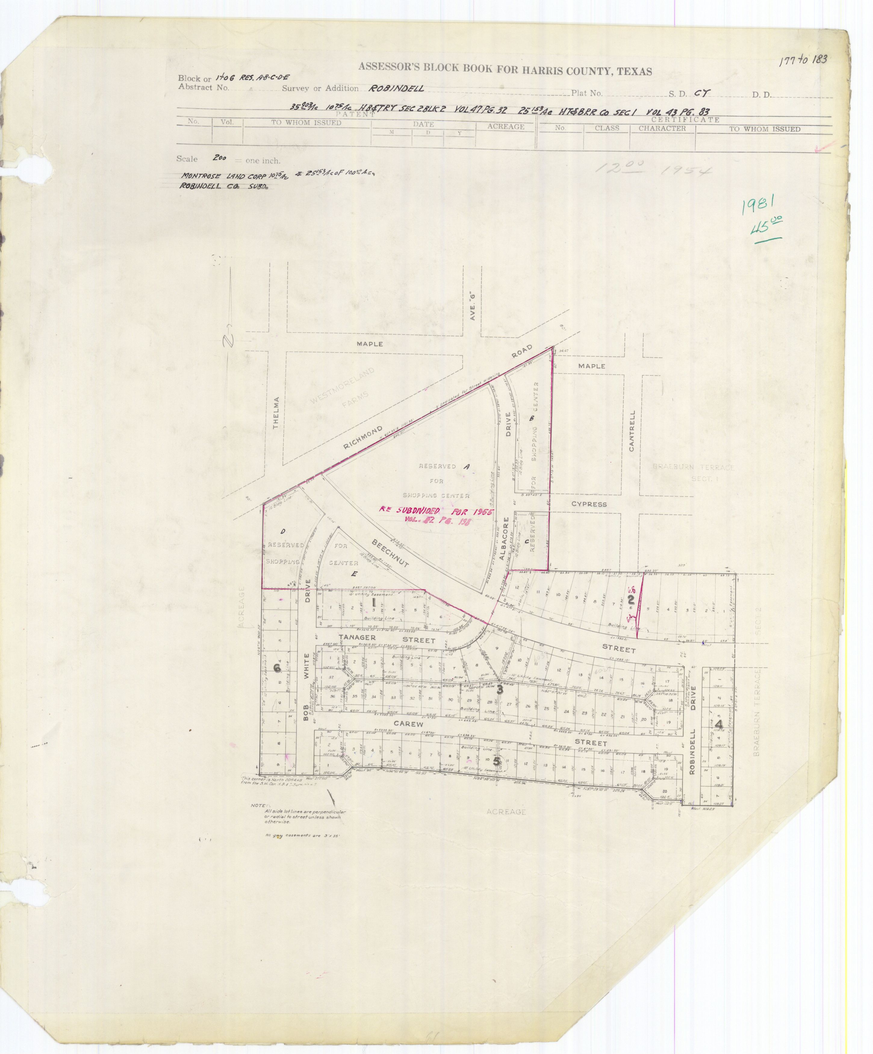
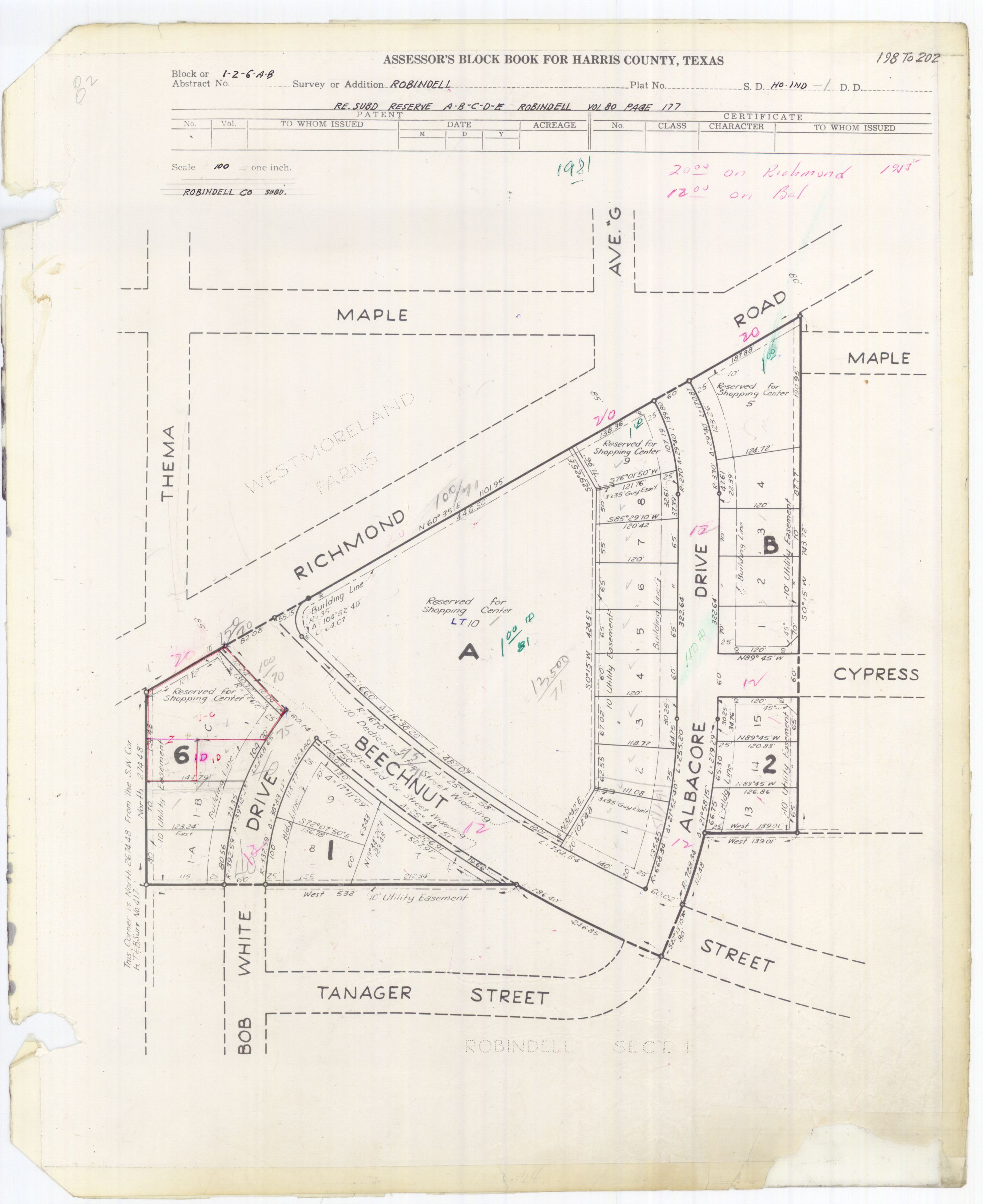
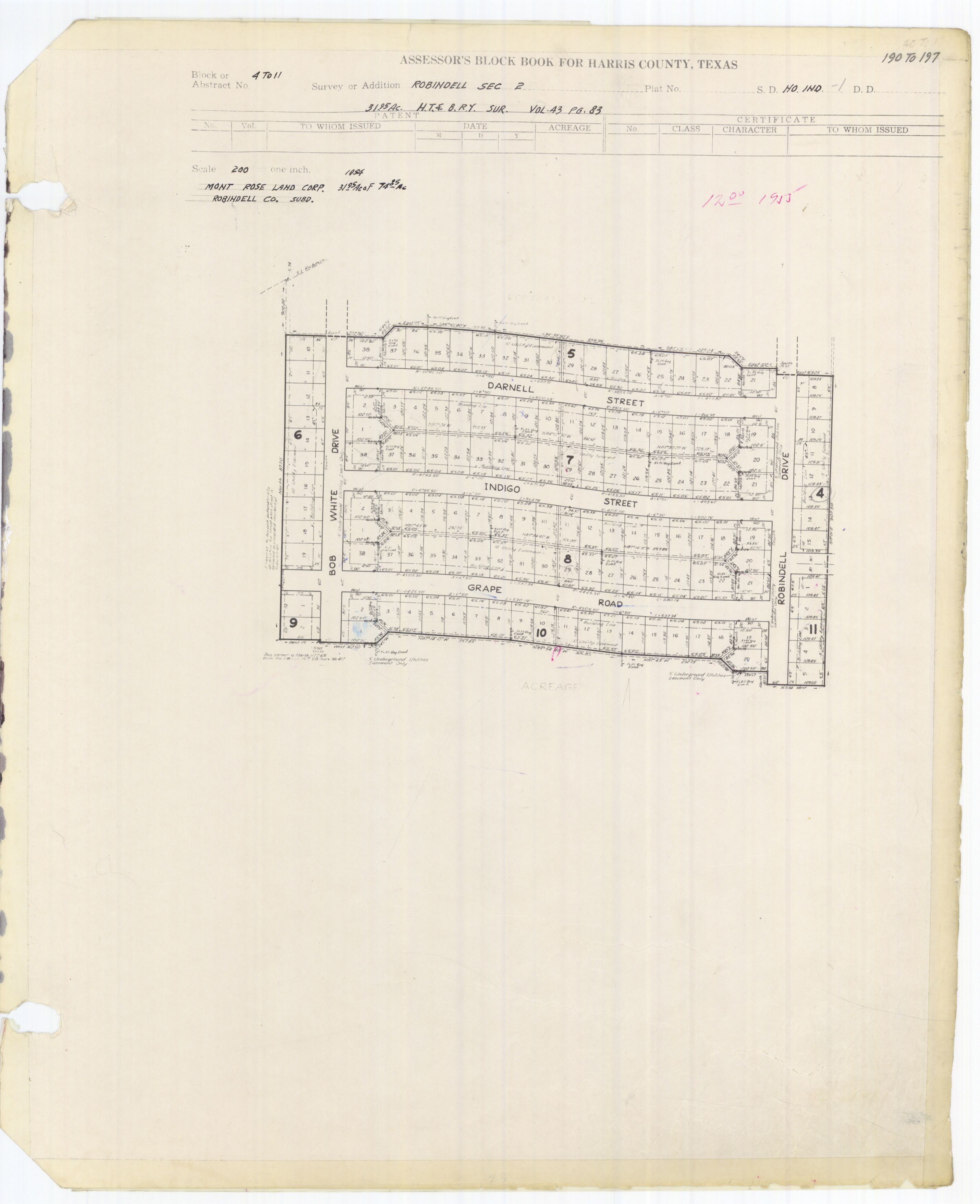
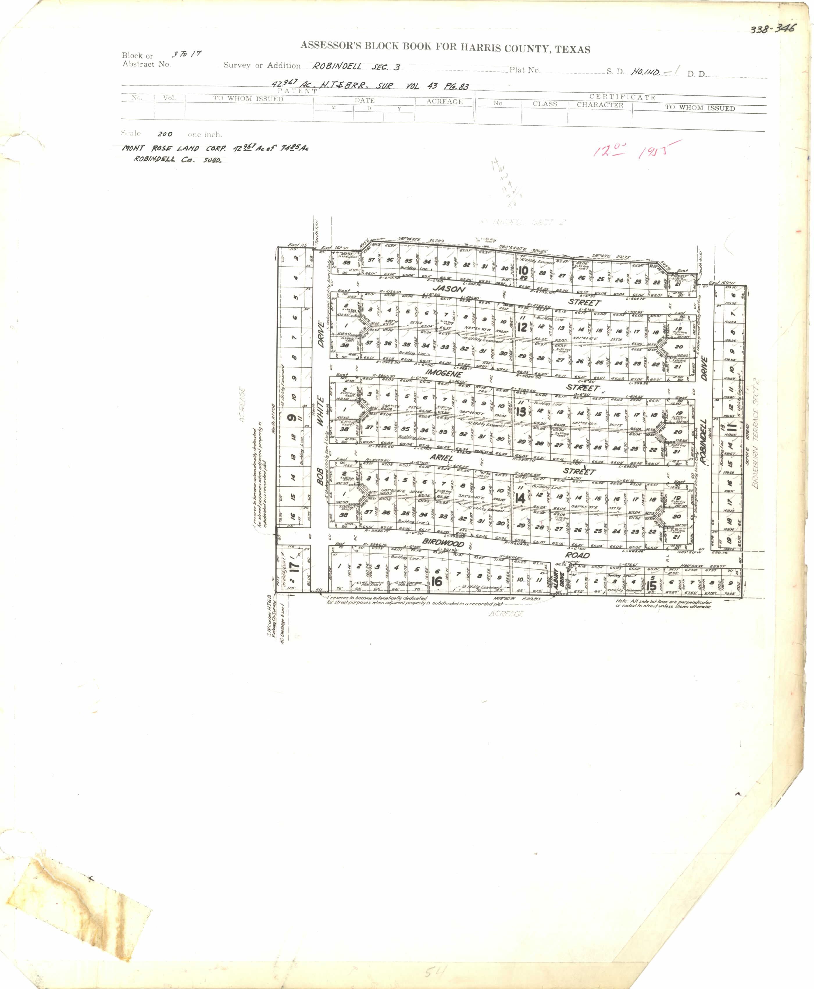
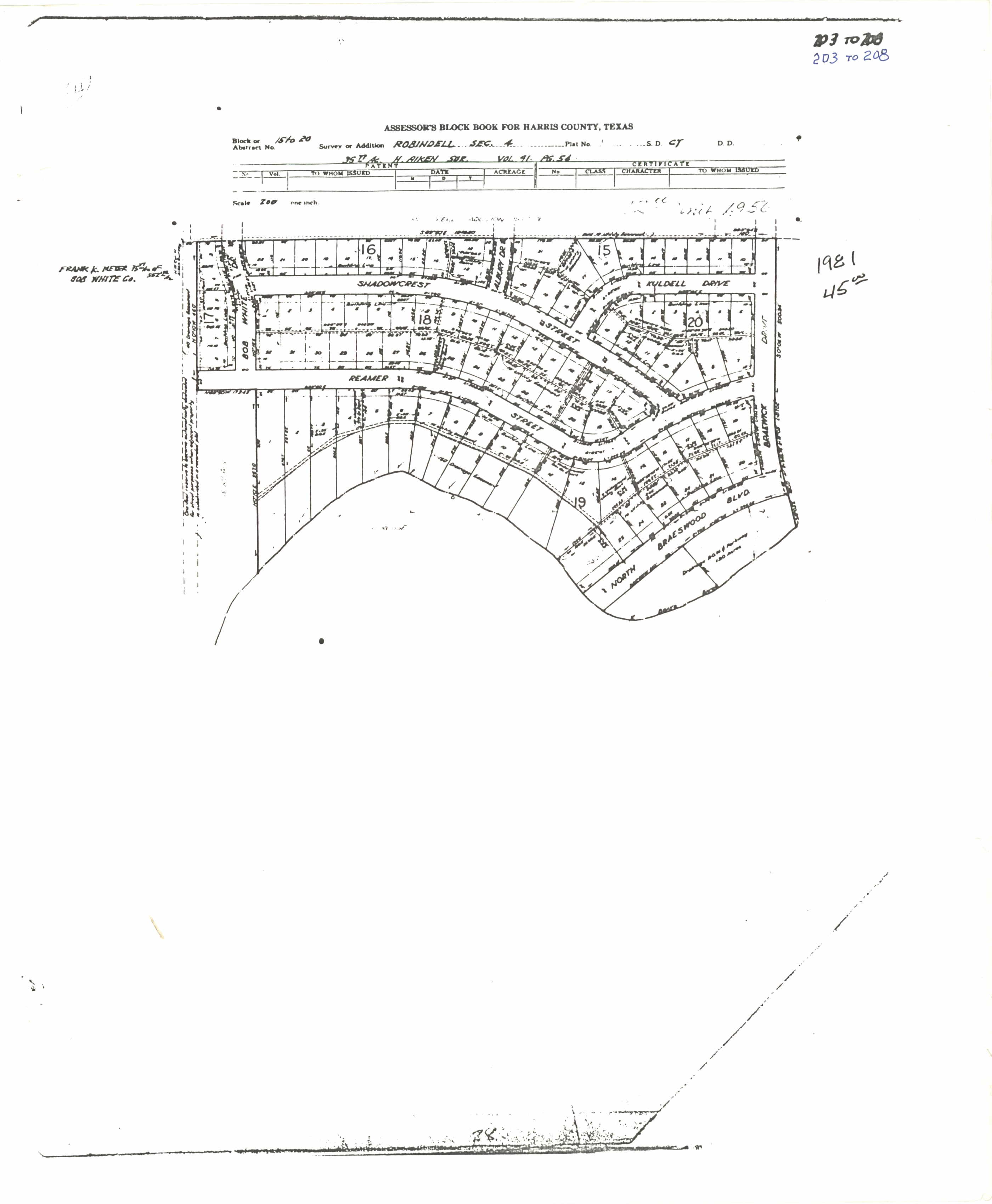
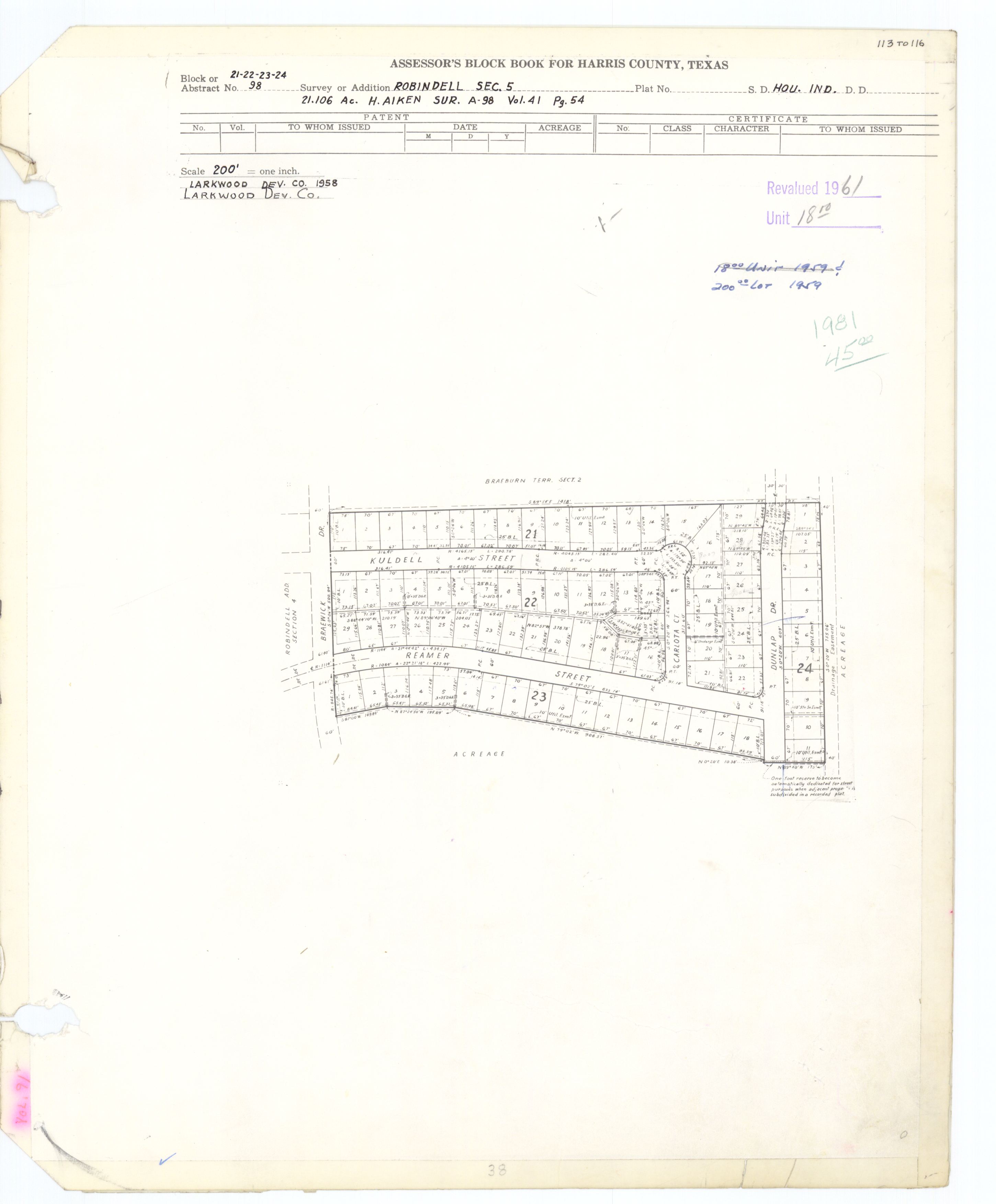
Braeburn is a community of subdivisions in southwest Houston, Texas along Brays Bayou west of Hillcroft Avenue and south of the Sharpstown community. The first of these middle class subdivisions was developed after World War II at a time when the Richmond Farm-to-Market Road provided the route into the city, rather than U.S. Highway 59. Development continued into the 1970s. The Braeburn Country Club is located in the center of the community. Subdivisions found here include Robindell, Braeburn Terrace, Braeburn Glen, Larkwood, Braeburn Valley, Bonham Acres, Braes Timbers and—the acreage lot subdivision—Brae Acres. The area also includes commercial and multi-family developments. Braeburn is notable for its large number of mid-century modern homes, tree lined streets, and location close to the Galleria, the Texas Medical Center, Reliant Park, the major freeways- 59, 610 and the Beltway. The communities of Braeburn have in recent years formed the Braeburn Superneighborhood, a coalition of Home Owner Associations, in order to interact more effectively with the City of Houston and other area agencies. The Brays Bayou hike and bike trail runs through the community, providing easy access to over 15 miles of excellent trails.

Manchester is a community in southeastern Houston, Texas, United States.

Kashmere Gardens is a historically African-American neighborhood in the northern 610 Loop area in Houston, Texas, United States. A group of single-family houses, many of which have large lots, Kashmere Gardens is between an industrial area and a rail corridor.

Memorial Hermann Southwest Hospital Hospital in Texas, United States

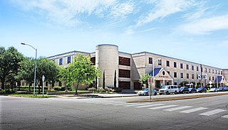
Memorial Hermann Southwest Hospital, formerly Southwest Memorial Hospital, is a hospital in Sharpstown Section 3, in Southwest Management District, Houston. It is a part of the Memorial Hermann Healthcare System. The communities it serves include Bellaire, Missouri City, Uptown Houston, and Southwest Houston, including Meyerland and Sharpstown.

Westwood (subdivision), Houston

Westwood is a residential subdivision in Southwest Houston, Texas. The subdivision is bounded by the 610 Loop, the Union Pacific railroad tracks, Stella Link Road, and Willowbend Boulevard. It has about 800 houses.

References

  1. Feldstein, Dan and Claudia Kolker. "Carless in Houston/Going carless/View is different from the slow lane." Houston Chronicle . June 15, 1997. Retrieved on August 8, 2011.
  2. 1 2 3 4 5 6 Feser, Katherine. "Robindell going strong after 40 years." Houston Chronicle . Sunday October 6, 1996. Business 10. Retrieved on August 8, 2011.
  3. Morganfield, Robbie. "City Hall adds 15 neighborhoods to renovation program." Houston Chronicle . Tuesday December 5, 1995. A18. Retrieved on August 9, 2011.
  4. 1 2 3 Connelly, Richard. "The Five Most Underrated Neighborhoods In Houston." Houston Press . Friday August 13, 2010. Retrieved on November 3, 2012.
  5. Mintz, Bill. "Residents win fight on Beechnut plan." Houston Chronicle . Wednesday September 21, 1988. Retrieved on August 8, 2011.
  6. Harris County blockbook maps: Section 1
  7. "Archived copy" (PDF). Archived from the original (PDF) on 2012-02-14. Retrieved 2011-10-23.CS1 maint: archived copy as title (link)
  8. "Archived copy" (PDF). Archived from the original (PDF) on 2012-02-14. Retrieved 2013-11-04.CS1 maint: archived copy as title (link)
  9. "Archived copy" (PDF). Archived from the original (PDF) on 2012-03-10. Retrieved 2012-03-10.CS1 maint: archived copy as title (link)
  10. "Archived copy" (PDF). Archived from the original (PDF) on 2008-02-16. Retrieved 2008-03-19.CS1 maint: archived copy as title (link)
  11. "Archived copy" (PDF). Archived from the original (PDF) on 2015-11-07. Retrieved 2012-02-14.CS1 maint: archived copy as title (link)
  12. The Bellaire Texan (Bellaire, Tex.), Vol. 2, No. 31, Ed. 1 Wednesday, September 14, 1955. p. 1 of 16 (see page). At the Portal to Texas History, University of North Texas. Retrieved on March 2, 2017. "215 N. 6th St., Bellaire, Texas"
  13. The Bellaire Texan (Bellaire, Tex.), Vol. 2, No. 31, Ed. 1 Wednesday, September 14, 1955. p. 4 of 16 (see page). At the Portal to Texas History, University of North Texas. Retrieved on March 2, 2017. "215 N. 6th St., Bellaire, Texas"
  14. The Bellaire & Southwestern Texan (Bellaire, Tex.), Vol. 24, No. 8, Ed. 1 Wednesday, June 25, 1975 Page: 2 of 47 (see page). At the Portal to Texas History, University of North Texas. Retrieved on March 2, 2017. "6622 Ferris St. Houston, Texas 77036"

Coordinates: 29°41′06″N95°29′56″W / 29.685°N 95.499°W / 29.685; -95.499