Memorial, Houston

Last updated
Memorial
Super neighborhood
MemorialCityHospitalHoustonTX.JPG
Coordinates: 29°46′52″N95°32′45″W / 29.7811°N 95.5459°W / 29.7811; -95.5459
CountryFlag of the United States.svg  United States
StateFlag of Texas.svg  Texas
County Harris County
CityFlag of Houston, Texas.svg  Houston
Area
[1]
  Total10.75 sq mi (27.8 km2)
Population
 (2013) [1] [2]
  Total44,413
  Density4,131/sq mi (1,595/km2)
Time zone Central Time Zone (CT)
ZIP codes
77079, 77055, 77024
Area code(s) 281, 832, 713, 346
Website memorialsn.org

The Memorial area of Houston, Texas is located west of Downtown, northwest of Uptown, and south of Spring Branch. The Memorial Super Neighborhood, as defined by the City of Houston, is bounded by Buffalo Bayou to the south, Barker Reservoir to the west, Westview to the north, and the Memorial Villages (Spring Valley Village, Piney Point Village, Bunker Hill Village, Hedwig Village, Hilshire Village and Hunters Creek Village), a contiguous group of independent municipalities, [3] to the east. [4]

Contents

A rich variety of residential architectural styles, particularly mid-century modern, can be found in the affluent forested neighborhoods of Memorial along Buffalo Bayou. [5] The area is also home to a number of major office and retail developments, including Memorial City, Town & Country Village, and CityCentre. A large portion of the Energy Corridor, a large business district heavily populated by energy-related firms, overlaps west Memorial along Eldridge Parkway and the Katy Freeway. [6] Memorial takes its name from Memorial Drive, an east–west arterial road which bisects the area. [1]

History

Prior to annexation by Houston, the Memorial area consisted of large country estates and farmland. [5] In the mid-1940s, the town of Addicks relocated to the western edge of the area after the construction of Addicks Reservoir by the U.S. Army Corps of Engineers inundated the original townsite. [7] This same flood control project, completed in the 1950s, created Barker Reservoir to the west of the area and channelized Buffalo Bayou from State Highway 6 to Beltway 8. [8]

Houston gradually annexed Memorial between the 1950s and 1980s. [9]

Rapid growth of the Houston metropolitan area in the 1960s led to the development of a number of subdivisions in the Memorial area, including Nottingham Forest, [10] Westchester, [11] and Fonn Villas. [12] The Memorial Bend subdivision, first developed in 1955, is particularly notable for its large collection of mid-century modern houses. [13] This development was accompanied by the reconstruction of U.S. Route 90 into Interstate 10. [14] Retail development paralleled residential growth; Memorial City Mall was established in 1962, followed by Town & Country Village in 1965. [15] [16]

Residents of Memorial Bend opposed the construction of Texas State Highway Beltway 8 through their neighborhood during the project's planning stages in the early 1960s, but an alternative western route along Dairy Ashford Road was deemed too costly. [17] Funding issues delayed the construction of Beltway 8 through Memorial until the late 1980s. [17]

Memorial continued to gain population between 1980 and 1990. [18]

From 1999 to 2003, Memorial City Mall underwent a $600 million renovation. [19] The mall and neighboring Memorial Hermann Memorial City Medical Center now anchor a large mixed-use district featuring multiple office towers, hotels, and apartments. [20] Nearby Town and Country Mall, constructed in the 1980s, was razed in 2005 and replaced with CityCentre, a walkable mixed-use district. [21]

Hurricane Harvey

In August and September 2017, portions of Memorial adjacent to Buffalo Bayou and its tributaries experienced severe flooding from record rainfall associated with Hurricane Harvey. Critical water levels in Addicks Reservoir to the north and Barker Reservoir to the west of the district forced the U.S. Army Corps of Engineers to amplify the release of floodwaters downstream into Buffalo Bayou well beyond normal levels, inundating low-lying neighborhoods near Terry Hershey Park and in the Memorial Villages. [22] Controlled reservoir releases and associated flooding were expected to last for up to two weeks after the passage of the storm. [23]

Buffalo Bayou's record-high level throughout Memorial rendered multiple major thoroughfares impassable, including Texas State Highway 6 and portions of Interstate 10; the sunken stretch of the Sam Houston Tollway near CityCentre was submerged for a week, causing significant damage to the roadway. [24] [25] Inundated homes in Memorial were subject to a mandatory evacuation, and the entire area was subject to an emergency curfew even after the expiration of the citywide curfew. [26] [27]

Government and infrastructure

Local government

In the 1990s, Memorial, along with River Oaks and Tanglewood, was described as one of Houston's "richest, most Republican neighborhoods." [28] In the first 1991 Mayor of Houston election, Bob Lanier received more votes than any other candidate in Memorial. [29] [30]

County, state, and federal representation

Harris County Precinct Three, represented by Steve Radack, includes Memorial. [31]

Memorial is part of Texas Senate Districts 7, 15 and 17, with the largest part in District 7. In the Texas House of Representatives, Memorial is included in Districts 132, 133, 136 and 138.

Memorial is in Texas's 7th congressional district, represented by Democrat Lizzie Pannill Fletcher. [32]

Harris Health System (formerly Harris County Hospital District) designated Northwest Health Center for ZIP code 77024. The nearest public hospital is Ben Taub General Hospital in the Texas Medical Center. [33]

Services

The United States Postal Service operates the Memorial Park Post Office at near Memorial City, serving ZIP code 77024. Of more recent construction is the Fleetwood Post Office, serving 77079. [34] [35]

Demographics

In 2015, the City of Houston-defined Memorial Super Neighborhood had 47,604 residents. 67% were non-Hispanic white, 14% were Hispanic, 11% were non-Hispanic Asian, 5% were non-Hispanic black, and 3% were non-Hispanic other. In 2000 the super neighborhood had 44,957 residents. 78% were non-Hispanic white, 10% were non-Hispanic Asians, 9% were Hispanics, and 2% each were non-Hispanic blacks and others. [36]

Education

Primary and secondary schools

Most of Memorial is zoned to Spring Branch Independent School District (SBISD). [37] The Houston Independent School District does not serve residents in Memorial. Students in the western end of the Memorial area attend Katy Independent School District schools. The area is generally known for the high quality of its public schools. [5]

In 2015, residents of the Katy ISD segments of Thornwood, in the Memorial area, attempted to leave Katy ISD and join Spring Branch ISD, citing long commutes to Katy schools. The Spring Branch ISD board denied their request. [38]

Public schools

For pre-kindergarten all residents in Spring Branch ISD are assigned to the Wildcat Way School in Memorial. [39] Zoned elementary schools in the Memorial area in Houston include Meadow Wood, Nottingham, Rummel Creek, Thornwood, Wilchester. In addition, sections are, in separate attendance zones, served by Bunker Hill Elementary School and Frostwood Elementary School in the City of Bunker Hill Village, as well as Memorial Drive Elementary School in City of Piney Point Village. [40] The district also operates Bendwood Elementary School, serving gifted/talented students in the SPIRAL program in grades 3 through 5 as well as utilizing the Preschool Program for Children with Disabilities for special needs students. [41]

Major middle schools in Memorial include Memorial Middle School and Spring Forest Middle School. In addition, Spring Branch Middle School, in the City of Hedwig Village, serves sections of Memorial. [42]

Memorial High School in Hedwig Village serves the eastern portion of the Memorial area, while Stratford High School in Memorial serves the western portion of the Memorial area. [43] Westchester Academy for International Studies is a Spring Branch ISD district-wide charter magnet school serving grades 6-12.

Private schools

Memorial Private High School, a private 6-12 school, is located in Memorial near Spring Forest Middle School. [44]

Private schools in the surrounding area:

Public libraries

Kendall Library KendallLibraryHouston.JPG
Kendall Library

Memorial is served by the Kendall Library of Houston Public Library (HPL), located on Eldridge Parkway, and the Spring Branch Memorial Branch of Harris County Public Library, in Hedwig Village.

Of all HPL branches the Kendall Library received the most severe damage during Hurricane Harvey in 2017; the damage, which affected the electronic system and elevator, but not most of the books as the majority were on the library's second floor, included mold and was so severe that HPL employees re-entered the branch several days after the flood. The total level of water ranged from 4.5 feet (1.4 m) to 5 feet (1.5 m). The library afterward enacted a $4 million project post-Harvey renovation program with a tentative 2019 opening. [48]

Colleges and universities

Houston Community College System (HCC) serves Spring Branch ISD and Katy ISD along with other school districts. [49]

Parks

The western two-thirds of Memorial is bordered to the south by Terry Hershey Park, a linear park which straddles the Buffalo Bayou between Barker Reservoir and Beltway 8. The park is named for local conservationist Terry Hershey, who founded the Bayou Preservation Association to prevent the Memorial section of the bayou from being lined with concrete. [50] Today, the park is a popular destination for running and bicycling. [51]

Other public parks located within Memorial include Bendwood Park, adjacent to Town and Country Village, and Nottingham Park, near Tully Stadium. [52] [53]

Another park near Memorial, Houston is Memorial Park. It's near I-10 West and the 610 South Loop. It is named one of the largest urban parks in Texas and in the United States. The park offers a 3-mile running track, tennis courts, a golf course and playgrounds. There are also various other trails to take you to lakes, ponds, and other peaceful settings.

Media

Neighborhoods

Energy Corridor

The Energy Corridor is an energy industry-oriented business district which overlaps with western Memorial. Within Memorial, the district generally runs parallel to Interstate 10 between Highway 6 and Kirkwood Road, and extends south of Buffalo Bayou along Eldridge Parkway. [55]

The entire district, which extends westward into Greater Katy, contains over 300 companies which employ 94,000 people. [56] One of the Energy Corridor's largest employers, BP America, is headquartered in the Memorial area at Westlake Park.

Memorial Bend

As of 2004 Memorial Bend had about 350 houses, with the majority being Mid-Century Modern and ranch houses; many were built in the late 1950s and early 1960s. That year five were recently built and therefore had different designs. The community is near Town & Country Village. [57]

Nottingham Forest

Looking east on Chadbourne Drive in Nottingham Forest, Section 8 Chadbourne.JPG
Looking east on Chadbourne Drive in Nottingham Forest, Section 8

Nottingham Forest ( 29°46′1.95″N95°36′54.16″W / 29.7672083°N 95.6150444°W / 29.7672083; -95.6150444 and 29°45′59.3346″N95°35′52.512″W / 29.766481833°N 95.59792000°W / 29.766481833; -95.59792000 ) is a group of subdivisions bordered by Memorial Drive to the north and the Buffalo Bayou to the south and west. The neighborhood was one of the first areas of far west Memorial to be developed in the 1960s. [58]

Nottingham Forest was the childhood home of comedian Bill Hicks. [59] Hicks jokingly referred to the neighborhood as a "strict Southern Baptist ozone". [60] [61]

Notable residents

Related Research Articles

<span class="mw-page-title-main">Harris County, Texas</span> County in Texas, U.S.

Harris County is a county located in the U.S. state of Texas; as of the 2020 census, the population was 4,731,145, making it the most populous county in Texas and the third most populous county in the United States. Its county seat is Houston, the largest city in Texas and fourth largest city in the United States. The county was founded in 1836 and organized in 1837. It is named for John Richardson Harris, who founded the town of Harrisburg on Buffalo Bayou in 1826. According to the July 2022 census estimate, Harris County's population has shifted to 4,780,913 comprising over 16% of Texas's population. Harris County is included in the nine-county Houston–The Woodlands–Sugar Land metropolitan statistical area, which is the fifth-most populous metropolitan area in the United States.

<span class="mw-page-title-main">Hedwig Village, Texas</span> City in Texas, United States

Hedwig Village is a city in Harris County, Texas, United States. The population was 2,370 at the 2020 census.

<span class="mw-page-title-main">Hunters Creek Village, Texas</span> City in Texas, United States

Hunters Creek Village is a city in Harris County, Texas, United States, part of the Greater Houston metropolitan area. The population was 4,385 at the 2020 census. It is part of a collection of upscale residential communities in west Houston known as the Memorial Villages.

<span class="mw-page-title-main">Piney Point Village, Texas</span> City in Texas, United States

Piney Point Village is a city in Harris County, Texas, United States. The population was 3,125 at the 2010 census. Piney Point Village is the wealthiest place in Texas, as ranked by per capita income. It is part of a collection of upscale residential communities in west Houston known as the Memorial Villages.

<span class="mw-page-title-main">The Woodlands, Texas</span> Census-designated place and special-purpose district in Texas, United States

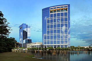
The Woodlands is a special-purpose district and census-designated place (CDP) in the U.S. state of Texas in the Houston–The Woodlands–Sugar Land metropolitan statistical area. The Woodlands is primarily located in Montgomery County, with portions extending into Harris County. The Woodlands is governed by The Woodlands Township, an organization that provides municipal services and is administered by an elected board of directors. As of the 2020 U.S. Census, the township had a population of 114,436 people.

<span class="mw-page-title-main">Katy, Texas</span> City in Texas, United States

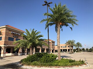
Katy is a city in the U.S. state of Texas. It is the Greater Katy area, itself forming the western part of the Greater Houston metropolitan area. Homes and businesses may have Katy postal addresses without being in the City of Katy. The city of Katy is approximately centered at the tripoint of Harris, Fort Bend, and Waller counties. Katy had a population of 21,894 at the 2020 U.S. census, up from 14,102 in 2010.

<span class="mw-page-title-main">Kingwood, Houston</span> Community of Houston and Master planned area in Texas, United States

Kingwood is a 14,000-acre (57 km2) master-planned community located in northeast Houston, Texas, United States. The majority of the community is located in Harris County with a small portion in Montgomery County. Known as the "Livable Forest," it is the largest master-planned community in Harris County and second-largest within the 10-county Houston-The Woodlands-Sugar Land metropolitan area. It was classified as a "census-designated place" during the 1990 census, when the population recorded was 37,397. It is on the east fork of the San Jacinto River.

<span class="mw-page-title-main">Spring Branch, Houston</span> Neighborhood in Houston, Texas, US

Spring Branch is a district in west-northwest Harris County, Texas, United States, roughly bordered by Tanner Road and Hempstead Road to the north, Beltway 8 to the west, Interstate 10 to the south, and the 610 Loop to the east; it is almost entirely within the city of Houston. Established by the Texas Legislature, the Spring Branch Management District exercises jurisdiction over the area.

<span class="mw-page-title-main">Spring Branch Independent School District</span> School district near Houston, Texas, United States

Spring Branch Independent School District is a school district headquartered in Hedwig Village, Texas, United States in Greater Houston. The district serves portions of western Houston, including most of Spring Branch. It also serves several small municipalities known as the Memorial Villages in its jurisdiction, such as Hedwig Village and Spring Valley Village. A majority of the district lies within Houston city limits.

Harrisburg is a community that is now located within the city of Houston, Texas, United States.

<span class="mw-page-title-main">Buffalo Bayou</span> Body of water in the U.S. state of Texas

Buffalo Bayou is a slow-moving body of water which flows through Houston in Harris County, Texas. Formed 18,000 years ago, it has its source in the prairie surrounding Katy, Fort Bend County, and flows approximately 53 miles (85 km) east through the Houston Ship Channel into Galveston Bay and the Gulf of Mexico. In addition to drainage water impounded and released by the Addicks and Barker reservoirs, the bayou is fed by natural springs, surface runoff, and several significant tributary bayous, including White Oak Bayou, Greens Bayou, and Brays Bayou. Additionally, Buffalo Bayou is considered a tidal river downstream of a point 440 yards (400 m) west of the Shepherd Drive bridge in west-central Houston.

<span class="mw-page-title-main">Katy Independent School District</span> School district in Texas, United States

The Katy Independent School District (KISD) is a public school district based in Katy, Texas, United States with an enrollment of over 85,700 students. In 2022, the district was given a grade of "A" by the Texas Education Agency.

Alief is a working-class suburb in Southwest Harris County, Texas, United States. Most of Alief is within the city limits of Houston, while a portion of the community is in unincorporated Harris County.

<span class="mw-page-title-main">Meyerland, Houston</span> Community in Houston, Texas

Meyerland is a community in southwest Houston, Texas, outside of the 610 Loop and inside Beltway 8. The neighborhood is named after the Meyer family, who bought and owned 6,000 acres (24 km2) of land in southwest Houston.

<span class="mw-page-title-main">Westchase, Houston</span> Place in Texas, United States

Westchase is a business district and neighborhood in western Houston, Texas, bounded by Westheimer Road on the north, Gessner Road on the east, Houston Center Boulevard on the west, and Westpark Tollway on the south. The area is bisected by Beltway 8. Westchase is adjacent to Greater Sharpstown, the International District, and the Royal Oaks Country Club subdivision. The area is immediately northeast of Alief.

<span class="mw-page-title-main">Greenspoint, Houston</span> Neighborhood and business district in Harris County, Texas, United States

Greater Greenspoint, also referred to as the North Houston District, is a 7-square-mile (18 km2) business district and a suburban neighborhood in northern Harris County, Texas, United States, located mostly within the city limits of Houston. Centered around the junction of Interstate 45 and Texas State Highway Beltway 8 near George Bush Intercontinental Airport, the area is a classic example of a planned edge city. The initial 2,000-acre (8.1 km2) retail and office development centered around Greenspoint Mall was a project of the Friendswood Development Company during the 1970s and early 1980s.

<span class="mw-page-title-main">Houston Energy Corridor</span> Business district of Greater Houston in Texas, United States

The Energy Corridor is a business district in Houston, Texas, located on the west side of the metropolitan area between Beltway 8 and the Grand Parkway. The district straddles a 7-mile (11 km) stretch of Interstate 10 from Kirkwood Road westward to Barker Cypress Road and extends south along Eldridge Parkway to Briar Forest Drive. Parts of the district overlap with the Memorial area of Houston. The district is located north of Westchase, another major business district of Houston, and east of Greater Katy.

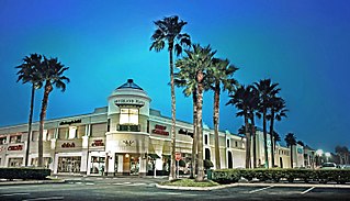
Greater Katy Area is the term often used to refer to a suburban region on the west side of the Greater Houston metropolitan area roughly corresponding to the boundaries of the Katy Independent School District. Many people and businesses in this area have a Katy address, but are not part of the city of Katy. This area includes the suburbs that surround the Katy city limits west to Pederson road, roughly east to State Highway 6, north to FM 529, and south to FM 1093/ Westpark Tollway Parkway. While these boundaries are not exact, it gives a rough outline of what most people consider Greater Katy, and what the USPS designates as "Katy, Texas" by assigning that city to addresses within zip codes that fall in this region. Most of Greater Katy is to the east of the city of Katy toward Houston and includes surrounding suburban areas and unincorporated areas that are not in the Houston city limits. The region includes parts of Harris County, Fort Bend County, and Waller County much as the City of Katy does. Greater Katy is one of the fastest-growing portions of the Houston metropolitan area and the state of Texas as a whole.

The Hispanic population in Houston is increasing as more immigrants from Latin American countries come to work in the area. As of 2006 the city has the third-largest Hispanic population in the United States. As of 2011, the city is 44% Hispanic. As of 2011, of the city's U.S. citizens that are Hispanic, half are age 18 or older, and are therefore at the age range eligible to vote. As of 2011 many Hispanics in Houston are not U.S. citizens, especially those living in Gulfton and Spring Branch, and are therefore ineligible to vote in elections. As a result, Hispanics have proportionally less representation in the municipal government than other ethnic groups. As of April 2011 two of the Houston City Council members are Hispanic, making up 18% of the council.

References

  1. 1 2 3 "Super Neighborhood Resource Assessment: Memorial" (PDF). City of Houston Planning and Development Department. August 2014. Retrieved 22 February 2017.
  2. "Super Neighborhoods Map" (PDF). City of Houston. Retrieved 22 February 2017.
  3. "The Memorial Villages". www.bunkerhilltx.gov. City of Bunker Hill Village. Retrieved 2017-02-21.
  4. "Super Neighborhood 16 - Memorial". www.houstontx.gov. City of Houston. Retrieved 2017-02-21.
  5. 1 2 3 Chang, Yushan. Newcomer's Handbook Neighborhood Guide: Dallas-Fort Worth, Houston, and Austin. First Books, 2006. ISBN   0912301708, 9780912301709. p. 145.
  6. "Energy Corridor a hotbed of car-free transportation planning". Houston Chronicle. October 3, 2014. Retrieved 2017-02-23.
  7. Edwards, Margaret Hopkins (2010-06-09). "Addicks, TX". tshaonline.org. Texas State Historical Association. Retrieved 2017-02-21.
  8. "Terry Hershey Park Surveying Contract" (PDF). Harris County Flood Control District. Harris County Flood Control District. December 2013.
  9. "Annexations in Houston" (PDF). City of Houston Planning and Development Department.
  10. "Welcome to Nottingham Forest". www.nottinghamforesthouston.org. Nottingham Forest Civic Association. Retrieved 2017-02-21.
  11. "Deed Restrictions". Westchester Homeowners Association. Retrieved 2017-02-21.
  12. "Fonn Villas". fonnvillas.org. Fonn Villas Civic Association. Retrieved 2017-02-21.
  13. Brichford, Michael (2003). "Where the '50s Were Fabulous: A Driving Tour of Memorial Bend" (PDF). Cite Magazine. 57: 10–11.
  14. Slotboom, Erik (2003). "Chapter 4: The Spokes". Houston Freeways. Oscar F. Slotboom. pp. 205–206. ISBN   0-9741605-3-9.
  15. "Memorial City". www.memorialcity.com. MetroNational. Retrieved 2017-02-21.
  16. Gonzales, J.R. (December 15, 2009). "Town & Country in Pictures". Houston Chronicle.
  17. 1 2 Slotboom, Eric (2003). "Chapter 5: The Loops". Houston Freeways. Oscar F. Slotboom. pp. 296–300. ISBN   0-9741605-3-9.
  18. Rodriguez, Lori. "Census tracks rapid growth of suburbia." Houston Chronicle . Sunday March 10, 1991. Section A, Page 1.
  19. Dodson, Doug (June 12, 2003). "Renovations near completion on Memorial City Mall project". Houston Chronicle. Retrieved 2017-02-21.
  20. Mulvihill, Jim (September 10, 2006). "Memorial City projects in the works". Houston Chronicle. Retrieved 2017-02-21.
  21. "CityCentre | ULI Case Studies". Urban Land Institute. 2015-01-30. Retrieved 2017-02-21.
  22. Shilcutt, Katharine (2017-09-02). "Flood Waters Could Continue to Cover Memorial for Weeks". Houstonia. Retrieved 2017-09-08.
  23. Schuppe, Jon (2017-08-31). "Hurricane Harvey dropped so much rain on Houston that some parts are still flooding". NBC News. Retrieved 2017-09-08.
  24. Paulsen, Stephen (2017-09-05). "Traffic Jams Cause Delays As Houston Returns to Work After Harvey". Houston Press. Retrieved 2017-09-08.
  25. Begley, Dug (2017-09-07). "Tollway took severe hit from Harvey, buckling pavement". Houston Chronicle. Retrieved 2017-09-08.
  26. Flynn, Meagan (2017-09-05). "Mayor Turner Partially Lifts Curfew in Houston". Houston Press. Retrieved 2017-09-08.
  27. Penzenstadler, Nick (2017-09-03). "Power being cut in flooded west Houston area under evacuation order". USA TODAY. Retrieved 2017-09-08.
  28. Mayer, Cynthia. "In Houston, Where Bush Still Drops In." Philadelphia Inquirer . August 18, 1992. 2
  29. Rodriguez, Lori. "Saying goodbye, with no regrets." Houston Chronicle . Saturday November 9, 1991. A31.
  30. Bernstein, Alan and Jim Simmon. "Black vote went solidly for Turner/Whitmire failed to produce split." Houston Chronicle . Thursday November 7, 1991. A21.
  31. "Precinct Maps : Precinct 3 Archived 2012-02-16 at the Wayback Machine ." Harris County. Accessed October 13, 2008.
  32. "Texas's 7th Congressional District - TX-07 Representatives & District Map".
  33. "Clinic/Emergency/Registration Center Directory By ZIP Code". Harris County Hospital District. 2001-11-19. Archived from the original on 2001-11-19. Retrieved 2021-04-08. - See ZIP code 77024. See this map for relevant ZIP code.
  34. "About the District." Memorial City District . Retrieved on January 25, 2009.
  35. "Post Office Location - MEMORIAL PARK." United States Postal Service . Retrieved on May 11, 2009.
  36. "Super Neighborhood Resource Assessment No. 16 Memorial" (PDF). City of Houston. Retrieved 2019-08-15.
  37. "District Maps". Houston Independent School District. Retrieved 2017-02-22.
  38. "Spring Branch ISD denies subdivision petition to join district, leave Katy ISD". Houston Chronicle . 2015-07-29. Retrieved 2017-01-01.
  39. "Early Childhood Archived 2006-06-05 at the Wayback Machine ." Spring Branch Independent School District . Retrieved on January 13, 2009.
  40. "Elementary School Boundaries Archived 2008-04-11 at the Wayback Machine ." Spring Branch Independent School District . Retrieved on January 13, 2009.
  41. "Bendwood Elementary > Home". bwe.springbranchisd.com. Retrieved 2016-01-28.
  42. "Middle School Boundaries Archived 2007-10-05 at the Wayback Machine ." Spring Branch Independent School District . Retrieved on January 13, 2009.
  43. "High School Boundaries Archived 2007-10-05 at the Wayback Machine ." Spring Branch Independent School District . Retrieved on January 13, 2009.
  44. "Memorial Private High School". Memorial Private High School. Retrieved 23 February 2017.
  45. "Pope John XXIII High golfers take second place". The Katy Rancher at the Houston Chronicle. 2013-11-04. Retrieved 2017-03-25. Pope John XXIII High School, [...] serves Houston's far west side, including areas of [...] Memorial [...]
  46. "Bus Services". The Village School . Retrieved 2019-03-30. - Village Bus Routes 2018-2019 and Memorial Bus Routes
  47. "Bus Schedule 2017-2018" (PDF). Awty International School . Retrieved 2019-04-05.
  48. Ward, Alyson (2018-07-19). "Nearly a year after Harvey's floods, six Houston libraries remain shuttered — some indefinitely". Houston Chronicle . Retrieved 2018-07-29.
  49. Sec. 130.182. HOUSTON COMMUNITY COLLEGE SYSTEM DISTRICT SERVICE AREA. Sec. 130.191.
  50. McGuire, Kim (August 23, 2016). "Terry Hershey: 'A force of nature for nature'". Houston Chronicle. Retrieved 2017-02-22.
  51. Shilcutt, Katharine. "Get Out: Biking the Anthills in Terry Hershey Park". Houstonia. Retrieved 2017-02-22.
  52. "Bendwood Park". Houston Parks Board.
  53. "Nottingham Park". Visit Houston.
  54. "About us". The Buzz Magazines. 2011-08-26. Retrieved 2017-02-26.
  55. "The Energy Corridor District: Land Use and Demographics" (PDF). The Energy Corridor District. 2016. Retrieved 24 February 2017.
  56. "Business Development". Energy Corridor District. Retrieved 25 February 2017.
  57. Pugh, Clifford (2004-04-11). "Will Houston find its true past in the '50s and '60s?". Houston Chronicle . Retrieved 2019-11-09.
  58. Richard West (April 1975). "Texas Monthly Reporter". Texas Monthly. Retrieved 2010-09-25.
  59. "Bill Hicks Biography, Bio, Tour Dates". Comedy Central. Archived from the original on 2010-12-22. Retrieved 2010-09-25.
  60. Paul Outhwaite, author of One Consciousness – an Analysis of Bill Hicks’ Comedy. "Bill Hicks Biography". Archived from the original on 2018-06-26. Retrieved 2010-09-25.{{cite web}}: |author= has generic name (help)
  61. Cynthia True (2002). American Scream: The Bill Hicks Story . Harper Collins. p.  4. ISBN   9780380803774 . Retrieved 2010-09-25. houston nottingham forest .
  62. Leitereg, Neal (January 2, 2015). "Astros great Jeff Bagwell sells Texas mansion for $11.98 million". Los Angeles Times . Retrieved September 25, 2016.
  63. Rogers, Brian. "Jurors hear details of accused former doctor's wealth." Houston Chronicle . Thursday September 15, 2011. Retrieved on November 20, 2011.
  64. Moreno, Jenalia. "Taqueria Arandas founder's daughter, 24, is boss." Houston Chronicle . December 3, 2006. Retrieved on March 31, 2014.
  65. "Harris County Appraisal District". www.hcad.org. Retrieved 2016-02-13.[ permanent dead link ]