
The City of Greater Geelong is a local government area in the Barwon South West region of Victoria, Australia, located in the western part of the state. It covers an area of 1,248 square kilometres (482 sq mi) and, had a population of 271,057 as of the 2021 Australian census. It is primarily urban with the vast majority of its population living in the Greater Geelong urban area, while other significant settlements within the LGA include Anakie, Balliang, Barwon Heads, Batesford, Ceres, Clifton Springs, Drysdale, Lara, Ocean Grove, Portarlington and St Leonards. It was formed in 1993 from the amalgamation of the Rural City of Bellarine, Shire of Corio, City of Geelong, City of Geelong West, City of Newtown, City of South Barwon, and parts of Shire of Barrabool and Shire of Bannockburn.

The City of Cessnock is a local government area in the Hunter region of New South Wales, Australia. The area under administration is located to the west of Newcastle. The largest population centre and council seat is the city of Cessnock.
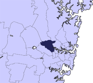
The City of Parramatta, also known as Parramatta Council, is a local government area located to the west and north-west of Sydney CBD in the Greater Western Sydney region. Parramatta Council is situated between the City of Ryde and Cumberland, where the Cumberland Plain meets the Hornsby Plateau, approximately 25 kilometres (16 mi) west of the Sydney central business district, in New South Wales, Australia. The city occupies an area of 84 square kilometres (32 sq mi) spanning across suburbs in Greater Western Sydney including the Hills District, and a small section of Northern Sydney to the far north east of its area. According to the 2021 census, City of Parramatta had an estimated population of 256,729. The city houses the Parramatta central business district which is one of the key suburban employment destinations for the region of Greater Western Sydney.

The City of Wollongong is a local government area in the Illawarra region of New South Wales, Australia. The area is situated adjacent to the Tasman Sea, the Princes Motorway and the Illawarra railway line.

Berrigan Shire is a local government area in the southern Riverina region of New South Wales, Australia. The Shire lies on the New South Wales State border with Victoria formed by the Murray River. The Shire is adjacent to the Newell and Riverina Highways. The Shire is a mainly agricultural region, with dairying, cattle raising, woolgrowing and cropping the main activities. The vast majority of the Shire is irrigated. Tourism is another major activity, concentrated on the river towns of Tocumwal and Barooga.

City of Wagga Wagga is a local government area in the Riverina region of southern New South Wales, Australia.

Parkes Shire is a local government area in the Central West region of New South Wales, Australia. The Shire is located adjacent to the Broken Hill railway line and the Newell Highway.

Wentworth Shire is a local government area in the far south-west Riverina region of New South Wales, Australia. This Shire is located adjacent to the Murray and Darling Rivers. The Shire's major roads are the Sturt and the Silver City Highways. The Shire includes the towns of Wentworth, Buronga, Gol Gol, Dareton and Pooncarie. The shire's namesake is explorer and politician William Wentworth.

The Bundaberg Region is a local government area in the Wide Bay–Burnett region of Queensland, Australia, about 360 kilometres (220 mi) north of Brisbane, the state capital. It is centred on the city of Bundaberg, and also contains a significant rural area surrounding the city. It was created in 2008 from a merger of the City of Bundaberg with the Shires of Burnett, Isis and Kolan.

The Rockhampton Region is a local government area (LGA) in Central Queensland, Australia, located on the Tropic of Capricorn about 600 kilometres (370 mi) north of Brisbane. Rockhampton is the region's major city; the region also includes the Fitzroy River, Mount Archer National Park and Berserker Range.

The Mackay Region is a local government area located in North Queensland, Queensland, Australia. Established in 2008, it was preceded by three previous local government areas with modern histories extending back as far as 1869.
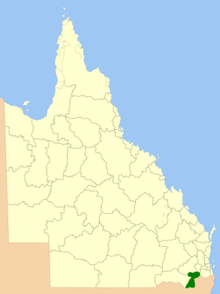
The Southern Downs Region is a local government area (LGA) in the Darling Downs region of Queensland, Australia. The region runs along the state's southern boundary with New South Wales and was created in 2008 from a merger of the Shire of Warwick and the Shire of Stanthorpe. As at 2024, it has an area of 7,088 square kilometres (2,737 sq mi).
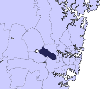
Cumberland Council, trading as Cumberland City Council, is a local government area located in the western suburbs of Sydney in the state of New South Wales, Australia. The Council was formed on 12 May 2016 from the merger of parts of the Cities of Auburn, Parramatta, and Holroyd.

Inner West Council is a local government area located in the Inner West region of Sydney in the state of New South Wales, Australia. The Inner West LGA makes up the eastern part of this wider region, and was formed on 12 May 2016 from the merger of the former Ashfield, Leichhardt and Marrickville councils.
The City of Johannesburg Metropolitan Municipality council consists of 270 city councilors elected by mixed-member proportional representation. The councillors are divided into two kinds: (a) 135 Ward councillors who have been elected by first-past-the-post voting in 135 wards; and (b) 135 councillors elected from party lists.
The 2022 South Australian local elections were held on 12 November 2022 to elect the councils of 66 of the 68 local government areas (LGAs) in South Australia. Many councils also held mayoral elections.
The 2026 South Australian local elections will be held in November 2026 to elect the councils and mayors of 67 of the 68 local government areas (LGAs) in South Australia. The elections will be conducted by the Electoral Commission of South Australia (ECSA).
The 2018 South Australian local elections were held in November 2018 to elect the councils of 67 of the 68 local government areas (LGAs) in South Australia. Many councils also held mayoral elections.

The 2014 South Australian local elections were held in November 2014 to elect the councils of 67 of the 68 local government areas (LGAs) in South Australia. Many councils also held mayoral elections.
The 2006 South Australian local elections were held in November 2006 to elect the councils of 66 of the 68 local government areas (LGAs) in South Australia. Many councils also held mayoral elections.