The watercourse is 24.8 kilometres (15.4mi) long.[1]
The Abatesco originates 200 metres (660ft) south of the summit of Monte Formicola, which is 1,981 metres (6,499ft) high, at an altitude of 1,700 metres (5,600ft) in the commune of San-Gavino-di-Fiumorbo.[2][3]
The source is very close to the famous GR20 hiking trail. The upper section is called the Tassi torrent. It only takes the name of Abatesco about 3 kilometres (1.9mi) from its source.[4]
It first flows from southwest to northeast, then generally flows from west to east. It flows into the Tyrrhenian Sea in the commune of Serra-di-Fiumorbo.[2]
Neighboring coastal rivers are the Fiumorbo to the north and the Travo to the south.
Watershed municipalities and cantons
In the Haute-Corse department alone, the Abatesco drains four communes[1] within one canton:
The Abatesco runs through the canton of Prunelli-di-Fiumorbo, the most southerly canton of Haute-Corse, in the arrondissement of Corte.
On almost all of its route, it serves as a boundary for the communes it runs along: Serra-di-Fiumorbo on its right bank, San-Gavino, then Isolaccio and finally Prunelli on its left bank.
Watershed
The surface of the Abatesco watershed is estimated as 111 square kilometres (43sqmi) by Sandre,[1] and as 89 square kilometres (34sqmi) by a study published in the French Bulletin of Fishing and Fish Farming.[5]
Managing body
The managing body since passage of the Corsican law of 22 January 2002 has been the Corsican Basin Committee (Comité de bassin de Corse).[6]
Tributaries
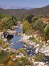
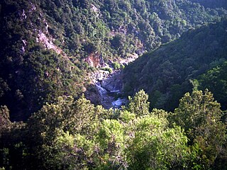
The Abatesco at Pietrapola
The Abastesco has nineteen referenced tributaries:[1]
The Strahler number of the Abatesco river is five from the Biaccino, Anzagara, Minagoli and Juva tributaries.
Human presence
The FORTEF tower in Migliacciaro
In the valley, in the places called Abbazia, Agnatello, Calzarello and Catastajo, a whole wood industry was born and prospered, run by the FORTEF company (Forêts - Terres et Forces du Fiumorbo). It extracted 6,000 cubic metres (210,000cuft) of sawed timber and employed 800 people in 1935, with 4,200 hectares (10,000 acres) of forests and 1,200 hectares (3,000 acres) of cultivable land. It fell into disuse in the nineteenth century.[15] In particular, at the height of 69 metres (226ft) on the Abatesco, a dam was built and hydroelectric plants (horizontal Pelton type or Francis type turbines[16]) at the place called Agnatello, supplied the timber industry which also existed at less than a kilometer, at a place called Abbazia at altitudes of 54 to 38 metres (177 to 125ft). In these same places, Corsican railways built a large railway bridge.[17]
By the sea, less than 1 kilometre (0.62mi), and at an altitude of 9 metres (30ft) the RT 10 (formerly RN 198) passes over the Abatesco. The old Roman road crossed about 500 metres (1,600ft) further north-west of this bridge, near the place called Chiarata.
On the river's course there are the Moulin de Branca and the Moulin de Biaccino, while the Moulin de Rizzale is on the Biaccino stream.
Ecology
The river and its tributaries are populated with trout.[5] A devastating flood for the fish population occurred in September 1989.
The mouth of the river has been classified as a Zone naturelle d'intérêt écologique, faunistique et floristique (ZNIEFF) since 1985 covering 162 hectares (400 acres), which includes the Canna marshes and the Gradugine pond to the north, and the Palo pond to the south.[18]
↑ "Pietrapola Les bains", site pietrapola les bains 20243 Isolaccio-di-Fiumorbu, Cyber3c, 2002, archived from the original on 14 April 2011, retrieved 17 April 2011
↑ "Abatesco", site Roger Brunet géographe, retrieved 17 April 2011
Pino is a commune in the Haute-Corse department of France on the island of Corsica.
Prunelli-di-Fiumorbo is a commune in the Haute-Corse department of France on the island of Corsica.
Moulins-sur-Orne is a commune in the Orne department in north-western France.
Boischampré is a commune in the Orne department in northwestern France. It was formed in 2015 by the merger of the former communes Saint-Christophe-le-Jajolet, Marcei, Saint-Loyer-des-Champs and Vrigny. The commune is part of the Forêt d'Écouves and Normandie-Maine Regional Natural Park.
Terres de Druance is a commune in the department of Calvados, northwestern France. The municipality was established on 1 January 2017 by merger of the former communes of Lassy, Saint-Jean-le-Blanc and Saint-Vigor-des-Mézerets.
The canton of Fiumorbo-Castello is an administrative division of the Haute-Corse department, southeastern France. It was created at the French canton reorganisation which came into effect in March 2015. Its seat is in Prunelli-di-Fiumorbo.
The Haute Perche Canal, despite its title, is a natural river, the Rivière de Haute-Perche, that has been slightly canalised to improve navigation between its mouth in the Bay of Bourgneuf at the port town of Pornic and the upstream settlements of Le Clion-sur-Mer, Chauvé and Arthon-en-Retz. It is located in the Pays de Retz in the Loire-Atlantique department and the Pays de la Loire region. It has also been known as the Canal de Pornic since the 16th century and was sometimes called the Étier de Haute Perche. Historically, it was called the Rouet, after the wheels of the water mills in the port.
The Aglia is a 9 kilometres (5.6 mi) long stream in the department of Haute-Corse, Corsica, a tributary of the Abatesco.
The Alesani River is a river in the Haute-Corse department in the island of Corsica, France.
The Étang de Diane is a coastal lagoon beside the Tyrrhenian Sea on the east coast of Haute-Corse department on the French island of Corsica. The lagoon served as a port for the Ancient Greeks, and then for the Romans. Today it is privately owned and mainly used for shellfish farming and fishing.
The Étang de Crovani is a coastal lagoon beside the Mediterranean Sea on the west coast of the Haute-Corse department on the French island of Corsica.
The Fiumorbo is a coastal river in the department of Haute-Corse, Corsica, France. It is dammed in two places to supply irrigation water and hydroelectricity. Between the two dams it runs through the spectacular Défilé de l’Inzecca, a Natura 2000 site.
Lac de Calacuccia is a reservoir in the Haute-Corse department of France formed by damming the Golo river. It provides hydroelectric power and water for irrigation in the dry season.
The Fango is a small coastal river in the department of Haute-Corse, Corsica, France. The Fango Valley was designated a biosphere reserve in 1977. It holds flora and fauna representative of all regions of Corsica from the coast to the highest mountains.
The Ospedale Reservoir is a reservoir in the Corse-du-Sud department of France on the island of Corsica. It holds drinking water for the southeast of the island, including Porto-Vecchio. It is surrounded by a forest that has been designated a Zone naturelle d'intérêt écologique, faunistique et floristique (ZNIEFF).
Teppe Rosse Reservoir is a reservoir in the Haute-Corse department of France, on the island of Corsica. It supplies water for drinking and irrigation.
The Buggiu or Valdolese, Vughio is a small coastal river in the department of Haute-Corse, Corsica, France. It flows into the Golfe de Saint-Florent in the north of the island. The estuary at its mouth has ecological value.
The Poggiolo is a small coastal stream in the department of Haute-Corse, Corsica, France. It enters the Tyrrhenian Sea from the east of the Cap Corse peninsula.
The Varagno is a stream in the department of Haute-Corse, Corsica, France. It is a tributary of the Fiumorbo.
The Saltaruccio is a stream in the department of Haute-Corse, Corsica, France. It is a tributary of the Fiumorbo.
This page is based on this Wikipedia article Text is available under the CC BY-SA 4.0 license; additional terms may apply. Images, videos and audio are available under their respective licenses.