The Asco (Corsican: Ascu) is a small river in the department of Haute-Corse, Corsica, France. It is a tributary of the Golo. The river rises in the Monte Cinto massif among some of the highest mountains of Corsica, passes a ski resort and the old village of Asco and cuts through a dramatic 4 kilometres (2.5mi) gorge before joining the Golo.
Footbridge over the Asco below Asco village, destroyed by a flood
The Asco is 34.01 kilometres (21.13mi) long. It crosses the communes of Asco, Canavaggia, Moltifao and Morosaglia.[1] It rises at an elevation of 2,130 metres (6,990ft). The source is to the southeast of the 2,706 metres (8,878ft)Monte Cinto.[2]
The Asco flows northwest, then north past the Haut-Asco resort, then runs northeast to the village of Asco, east-northeast to the south of the village of Molifao, then east to a point just north of Ponte Leccia, where it joins the Golo.[2] Its mouth is at an elevation of 184 metres (604ft).
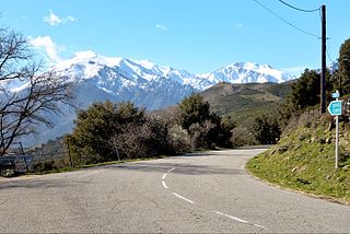
The Tartagine river joins the Asco about 2 kilometres (1.2mi) above the confluence of the Asco with the Golo. The D147 follows the river from Haut-Asco to Moltifao, then the D47 follows it to Ponte Leccia.[2] The D147 is a narrow, steep and winding but well-built road.[3]
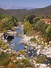
Valley
Lower valley and gorge
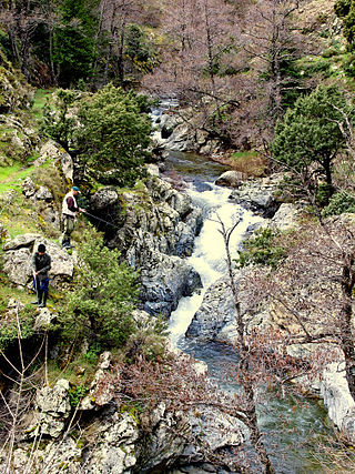
From the start of the D147 by Moltifao, the village of Asco is about 12 kilometres (7.5mi) upstream.[3] The Asco gorge is a defile almost 4 kilometres (2.5mi) long cut through red granite below Asco village.[4] It runs through a rugged landscape of steep cliffs and granite rocks. In it the river has carved out large natural pools.[3] There is little vegetation apart from some juniper and a few pines growing on the steep rick faces. The gorge draws many tourists in the summer months, attracted by its rugged topography and wild animals.[4]
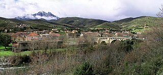
Village and Genoese bridge
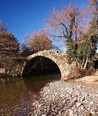
Genoese bridge and swimming pool
Asco village is at an elevation of 650 metres (2,130ft). The village is surrounded by junipers, and clings to the mountainside.[4] The road to this village was first opened in 1936. Today many of the old houses have been renovated. The village has a war memorial and the parish church of Archangel Saint Michael, with stone walls and a bell tower.[3] The church was built in the 11th century, and is classified.[4]
The nearby Genoese bridge was built in the 15th century when Corsica was occupied by the Republic of Genoa. It is below Asco village at an altitude of 535 metres (1,755ft) on a winding secondary road that ends at the bridge. There is a natural swimming pool below the bridge, with cool water around 15°C (59°F) in summer.[3]
Upper valley
Above Asco, the road continues for 14 kilometres (8.7mi), passes through the Asco communal forest and ends at Haut-Asco, a small ski resort at an altitude of 1,450 metres (4,760ft). The resort opens when there is enough snow, and has two fairly easy 600 metres (2,000ft) ski slopes and two 100 metres (330ft) beginner slopes. There is an eco-museum at Haut-Asco. The GR20 (Grande Randonnée 20) hiking trail passes through Haut-Asco. It is a 180 kilometres (110mi) trail that crosses the high mountain range of Corsica.[3]
The upper Asco valley has an alpine climate and alpine landscapes. The Stagnu plateau holding the ski resort is surrounded by a crest with some of the highest peaks in Corsica, including Capu Biancu: 2,562 metres (8,406ft), Capu au Verdatu: 2,583 metres (8,474ft), Punta Selolla: 2,592 metres (8,504ft), Capu Ciuntrone: 2,656 metres (8,714ft), Monte Cinto: 2,706 metres (8,878ft), Pointe des Éboulis: 2,607 metres (8,553ft), Punta Crucetta: 2,499 metres (8,199ft), Capu Larghia: 2,503 metres (8,212ft), Punta Minuta: 2,556 metres (8,386ft), Punta Rossa: 2,247 metres (7,372ft), Punta Missoghiu: 2,201 metres (7,221ft).[4]
Hydrology
Measurements of the river flow were taken at the Morosaglia [Ponte-Leccia] station from 1959 to 2021. The watershed above this station covers 365 square kilometres (141sqmi). Annual precipitation was calculated as 440 millimetres (17in). The average flow of water throughout the year was 5.08 cubic metres per second (179cuft/s).[5]
Average flow (cubic meters per second) by month for the period 1959 to 2021[5]
Month
Flow
Jan
6.800
Feb
7.570
Mar
8.690
Apr
8.060
May
6.240
Jun
2.640
Jul
0.895
Aug
0.733
Sep
1.150
Oct
2.760
Nov
7.480
Dec
8.190
Tributaries
The following streams (ruisseaux) are tributaries of the Asco:[1]
The Golo is the longest river on the island of Corsica, France, at 89.4 kilometres (55.6 mi)
Asco is a commune in the Haute-Corse department of France on the island of Corsica.
Albertacce is a commune in the Haute-Corse department in the Corsica region of France.
Morosaglia is a commune in the Haute-Corse department, on the island of Corsica, France. Since 2015, it is the seat of the canton of Golo-Morosaglia.
Ponte Leccia is a French village, part of the municipality (commune) of Morosaglia, in the department of Haute-Corse, Corsica. Its name in Corsican language is U Ponte à a Leccia.
Monte San Petrone is a mountain in the department of Haute-Corse on the island of Corsica, France. It is the highest mountain in the Monte San Petrone massif, the southernmost of the schist massifs of the northeast of the island.
Punta Artica or Monte Artica is a mountain in the department of Haute-Corse on the island of Corsica, France. It is in the Monte Rotondo massif.
The Capu Biancu is a mountain in the department of Haute-Corse on the island of Corsica, France.
The Monte Cinto massif is one of the main massifs in the island of Corsica, France, taking its name from the highest mountain in Corsica, Monte Cinto. It is the northernmost and highest of the four massifs that form the spine of the island. The massif is mostly in the Haute-Corse department, but the southwest of the massif is in the Corse-du-Sud department.
The Tartagine is a river in the department of Haute-Corse, Corsica, France. It flows through the Monte Cinto massif. It is a tributary of the Asco, which in turn is a tributary of the Golo.
The Casaluna is a small river in the department of Haute-Corse, Corsica, France. It is a tributary of the Golo.
The Tagnone is a small river in the department of Haute-Corse, Corsica, France. It is a tributary of the river Tavignano.
The Fango is a small coastal river in the department of Haute-Corse, Corsica, France. The Fango Valley was designated a biosphere reserve in 1977. It holds flora and fauna representative of all regions of Corsica from the coast to the highest mountains.
The Figarella is a small coastal river in the northwest of the department of Haute-Corse, Corsica, France.
The Erco is a stream in the department of Haute-Corse, Corsica, France. It is a tributary of the Golo.
The Ese is a river in the department of Corse-du-Sud, Corsica, France. It is a tributary of the Prunelli river, which it joins in the Lac de Tolla.
Capo al Berdato is a mountain in the department of Haute-Corse on the island of Corsica, France. It is in the Monte Cinto massif.
Punta Minuta is a 2,556 metres (8,386 ft) mountain in the department of Haute-Corse on the island of Corsica, France. It is in the Monte Cinto massif.
The Col de San Quilico or collo di San Quilico is a mountain pass in the Haute-Corse department of Corsica, France. It is a road pass on Territorial Route 20, between Corte and Ponte Leccia (Morosaglia).
Monte Padro is a 2,389 metres (7,838 ft) mountain in the department of Haute-Corse on the island of Corsica, France. It is in the Monte Cinto massif.
This page is based on this Wikipedia article Text is available under the CC BY-SA 4.0 license; additional terms may apply. Images, videos and audio are available under their respective licenses.