Chiola | |
---|---|
Location | |
Country | France |
Region | Corsica |
Department | Haute-Corse |
Physical characteristics | |
Mouth | Tyrrhenian Sea |
• coordinates | 41°53′11″N9°24′05″E / 41.8864°N 9.4015°E |
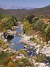
The Chiola (French : Ruisseau de Chiola) is a small coastal stream in the department of Haute-Corse, Corsica, France. It enters the Tyrrhenian Sea from the east of the island.
The Chiola is 11.63 kilometres (7.23 mi) long and flows through the commune of Solaro. [1] It rises to the north of the 1,122 metres (3,681 ft) Punta Mozza and flows east-northeast, and then east, through the Foret Territoriale de Tova. [2] It runs under the T10 coastal highway and enters the sea to the south of the Marine de Solaro resort. The Plage Chiola, a beach, extends south from the mouth of the stream. [3] Its course is south of the Travo and north of the Solenzara. [2]
The following streams (ruisseaux) are tributaries of the Chiola (ordered by length): [1]