Valley
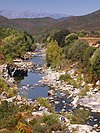
The Tagnone valley lies between the Tavignanu and Fium'Orbu valleys. It is smaller than these valleys and more isolated. The head of the valley is the ridge that connects the 824 metres (2,703 ft) Punta della Pinghella to the 1,524 metres (5,000 ft) Punta Paglia. To the north the valley is flanked by relatively low slopes. To the south it is separated from the Fium'Orbu valley by a line of heights that are above 1,000 metres (3,300 ft) high until the edge of the coastal plain. The villages of Vezzani and Pietroso cling to the slopes in the upper part of the narrow valley.
The environment on the north-facing slopes favors forestry, and laricio pines of the Rospa-Sorba national forest grow on the foothills of Punta Paglia above the villages. The valley floor is not wide and flat enough for agriculture, which is confined to terraces around Vezzani, Pietroso and a few hamlets. The slopes and river banks are covered by maquis shrubland. There are some traces of copper mining beside the RD343.

Aghione is a commune in the Haute-Corse department of France on the island of Corsica.

Altiani is a commune in the Haute-Corse department of France on the island of Corsica.

Antisanti is a commune in the Haute-Corse department of France on the island of Corsica.

The Tavignano is a river on the island of Corsica, France.

The Liamone river is a river of Corsica, France. The river gave its name to the former French department of Liamone. In antiquity, it bore the Latin name Circidius.

The Abatesco is a French coastal river which flows through the Haute-Corse department and empties into the Tyrrhenian Sea.

The Aglia is a 9 kilometres (5.6 mi) long stream in the department of Haute-Corse, Corsica, a tributary of the Abatesco.
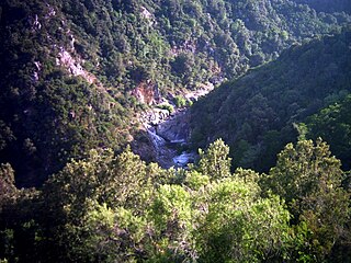
The Fiumorbo is a coastal river in the department of Haute-Corse, Corsica, France. It is dammed in two places to supply irrigation water and hydroelectricity. Between the two dams it runs through the spectacular Défilé de l’Inzecca, a Natura 2000 site.

The Vecchio is a river in the department of Haute-Corse, Corsica, France. It is a tributary of the river Tavignano.

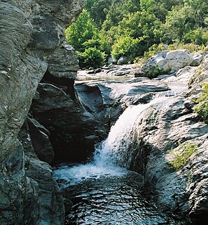
The Restonica is a small river in the department of Haute-Corse, Corsica, France. It is a tributary of the river Tavignano. The river has a steep and rocky course with many pools and waterfalls. The valley contains two lakes, and is a popular tourist destination.

The Fango is a small coastal river in the department of Haute-Corse, Corsica, France. The Fango Valley was designated a biosphere reserve in 1977. It holds flora and fauna representative of all regions of Corsica from the coast to the highest mountains.

The Fium'Albino is a small coastal river in the departments of Corse-du-Sud and Haute-Corse, Corsica, France. Its mouth opens into the Gulf of St Florent in the Mediterranean Sea on the west of the Cap Corse peninsula.

Bacciana Reservoir is a reservoir in the Haute-Corse department of France, on the island of Corsica. It supplies water for drinking and irrigation.

Teppe Rosse Reservoir is a reservoir in the Haute-Corse department of France, on the island of Corsica. It supplies water for drinking and irrigation.

The Prunelli is a small coastal river in the department of Corse-du-Sud, Corsica, France. It flows into the Golfe d'Ajaccio on the Mediterranean Sea.

The Cruzzini is a river in the center of the department of Corse-du-Sud, Corsica, France. It is a tributary of the river Liamone. The valley is isolated, heavily wooded, and surrounded by high and steep mountains. There is little tourism, and the population is poorer and older than in the island as a whole.

The Porto is a small coastal river in the northwest of the department of Corse-du-Sud, Corsica, France.
The Olmeta is a small coastal stream in the department of Haute-Corse, Corsica, France. It enters the Mediterranean Sea from the west of the Cap Corse peninsula.
The Varagno is a stream in the department of Haute-Corse, Corsica, France. It is a tributary of the Fiumorbo.

The Saltaruccio is a stream in the department of Haute-Corse, Corsica, France. It is a tributary of the Fiumorbo.
This page is based on this
Wikipedia article Text is available under the
CC BY-SA 4.0 license; additional terms may apply.
Images, videos and audio are available under their respective licenses.