Course
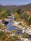
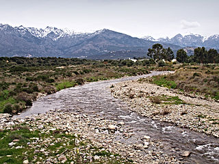
The Regino is 19.33 kilometres (12.01 mi) long. It crosses the communes of Belgodère, Feliceto, Occhiatana, Speloncato, Santa-Reparata-di-Balagna and Ville-di-Paraso. [1]
The Regino rises in the canton of Feliceto to the west of the 1,688 metres (5,538 ft) San Parteo mountain. It flows in a north-northwest direction, passing between the villages of Feliceto and Nessa, then turns to run in a northeast direction to its mouth on the sea. It is dammed to the south of L'Île-Rousse to form the Lac de Codole. The dam was built in the early 1980s by the Société de Développement Agricole de la Corse (SOMIVAC) to supply water to the eastern part of the Balagne for drinking and irrigation.
Watershed
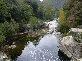
There are about 90 kilometres (56 mi) of streams in the Reginu watershed, which covers more than 110 square kilometres (42 sq mi). The reservoir is supplied by a watershed of 39 square kilometres (15 sq mi). The Reginu valley has a Mediterranean climate, with little rain in the summer. It regularly has strong west or southwest winds. The landscape includes pastures, cultivated olive, almond and citrus groves, and abandoned scrub and forest. Vegetation includes heather ( Erica arborea ), Arbutus unedo , oak forests ( Quercus ilex , Quercus suber and some Quercus pubescens ), lavender ( Lavandula stoechas ), rosemary (Rosmarinus officinalis), Genista corsica and many Cistus species.

The Acqua Tignese is a stream in the Haute-Corse department of the Corsica region that has its mouth north of Cap Corse, in the Ligurian Sea.

The Bevinco is a small river in the northeast of the Haute-Corse department on the French island of Corsica. It is the main tributary of the Étang de Biguglia, the largest wetland in Corsica.
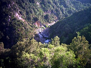
The Fiumorbo is a coastal river in the department of Haute-Corse, Corsica, France. It is dammed in two places to supply irrigation water and hydroelectricity. Between the two dams it runs through the spectacular Défilé de l’Inzecca, a Natura 2000 site.

Lac de Calacuccia is a reservoir in the Haute-Corse department of France formed by damming the Golo river. It provides hydroelectric power and water for irrigation in the dry season.
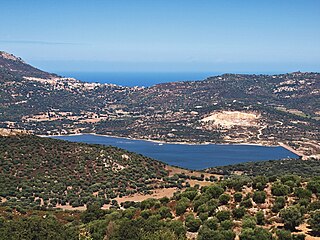
Codole Reservoir is a reservoir in the Haute-Corse department of France, on the island of Corsica. It supplies water for drinking and irrigation. The reservoir and its immediate surroundings are important as a biotope that offers habitat for many species of birds, reptiles and amphibians

The Fango is a small coastal river in the department of Haute-Corse, Corsica, France. The Fango Valley was designated a biosphere reserve in 1977. It holds flora and fauna representative of all regions of Corsica from the coast to the highest mountains.

The Luri is a coastal stream in the department of Haute-Corse, Corsica, France. It flows across the Cap Corse peninsula to the Tyrrhenian Sea.

The Sisco is a small coastal stream in the department of Haute-Corse, Corsica, France. It enters the Tyrrhenian Sea from the east of the Cap Corse peninsula.

The Ospedale Reservoir is a reservoir in the Corse-du-Sud department of France on the island of Corsica. It holds drinking water for the southeast of the island, including Porto-Vecchio. It is surrounded by a forest that has been designated a Zone naturelle d'intérêt écologique, faunistique et floristique (ZNIEFF).

The Lac de Tolla is a reservoir in the Corse-du-Sud department of France on the island of Corsica. It is the largest lake on Corsica, and powers a hydroelectric plant.

Bacciana Reservoir is a reservoir in the Haute-Corse department of France, on the island of Corsica. It supplies water for drinking and irrigation.
Trévadine Reservoir is a reservoir in the Haute-Corse department of France, on the island of Corsica. It stores water for drinking and irrigation, which is fed to reservoirs in the coastal plain.
The Oso is a small coastal river in the southeast of the department of Corse-du-Sud, Corsica, France.
The Rizzanese is a coastal river in the southwest of department of Corse-du-Sud, Corsica, France. It is dammed near Sorbollano to form the Rizzanese Reservoir, which stores water for irrigation and supplies the largest hydroelectric power plant in Corsica, with installed capacity of 55 MW. It flows into the Mediterranean Sea near the town of Propriano.

The Ortolo is a coastal river in the southwest of the department of Corse-du-Sud, Corsica, France. It is dammed to store water for irrigation.
The Buggiu or Valdolese, Vughio is a small coastal river in the department of Haute-Corse, Corsica, France. It flows into the Golfe de Saint-Florent in the north of the island. The estuary at its mouth has ecological value.

The Santu River is a small coastal river in the department of Haute-Corse, Corsica, France.
The Seccu River is a small coastal river in the department of Haute-Corse, Corsica, France.

The Poggiolo is a small coastal stream in the department of Haute-Corse, Corsica, France. It enters the Tyrrhenian Sea from the east of the Cap Corse peninsula.
The Olmeta is a small coastal stream in the department of Haute-Corse, Corsica, France. It enters the Mediterranean Sea from the west of the Cap Corse peninsula.
This page is based on this
Wikipedia article Text is available under the
CC BY-SA 4.0 license; additional terms may apply.
Images, videos and audio are available under their respective licenses.