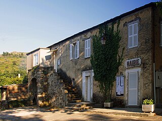
Rapale is a commune in the French Department of Haute-Corse on the island of Corsica.

The Agriates Desert or the Agriates is an area of Corsica split between the micro-regions of Balagne and Nebbio in Haute-Corse.

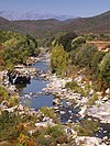
The Abatesco is a French coastal river which flows through the Haute-Corse department and empties into the Tyrrhenian Sea.

The Acqua Tignese is a stream in the Haute-Corse department of the Corsica region that has its mouth north of Cap Corse, in the Ligurian Sea.

The Alesani River is a river in the Haute-Corse department in the island of Corsica, France.

The Aliso River is a small coastal river in the department of Haute-Corse, Corsica, France.

Monte Astu or Monte Asto is a mountain in the department of Haute-Corse on the island of Corsica, France.

The Col de Bigorno Corsican: Bocca di Bigornu), or Bigorno Pass, is a mountain pass in the Haute-Corse department of Corsica, France.

The Regino River is a small coastal river in the department of Haute-Corse, Corsica, France.

The Buccatoggio, or Bucatoggio, is a small coastal river in the department of Haute-Corse, Corsica, France. It rises in the Monte San Petrone massif and flows into the Tyrrhenian Sea on the east of the island.

The Prunelli is a small coastal river in the department of Corse-du-Sud, Corsica, France. It flows into the Golfe d'Ajaccio on the Mediterranean Sea.
The Chiuvone is a small river in the department of Corse-du-Sud, Corsica, France. It is a tributary of the river Rizzanese. There is a small hydroelectric power dam on the river.

The Ese is a river in the department of Corse-du-Sud, Corsica, France. It is a tributary of the Prunelli river, which it joins in the Lac de Tolla.

The Ortolo is a coastal river in the southwest of the department of Corse-du-Sud, Corsica, France. It is dammed to store water for irrigation.

The Cruzzini is a river in the center of the department of Corse-du-Sud, Corsica, France. It is a tributary of the river Liamone. The valley is isolated, heavily wooded, and surrounded by high and steep mountains. There is little tourism, and the population is poorer and older than in the island as a whole.

The Santu River is a small coastal river in the department of Haute-Corse, Corsica, France.

The Liscu ) is a small coastal river in the north of the department of Haute-Corse, Corsica, France.

The Poggiolo is a small coastal stream in the department of Haute-Corse, Corsica, France. It enters the Tyrrhenian Sea from the east of the Cap Corse peninsula.
The Olmeta is a small coastal stream in the department of Haute-Corse, Corsica, France. It enters the Mediterranean Sea from the west of the Cap Corse peninsula.

The Col de Santo Stefano Corsican: Bocca di San Stefanu) is a mountain pass in the Haute-Corse department of Corsica, France. It is one of the main passes in Corsica, running between the massifs of Monte Stello to the north and Monte Astu to the south. It provides a route from the Saint-Florent region to the northwest and Biguglia in the eastern coastal plain.
This page is based on this
Wikipedia article Text is available under the
CC BY-SA 4.0 license; additional terms may apply.
Images, videos and audio are available under their respective licenses.