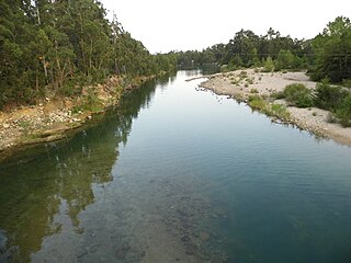
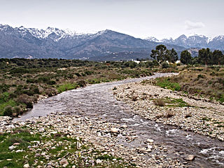
The Bravona rises to the northeast of the 1,724 metres (5,656ft) Punta di Caldane. In its upper reaches it flows west, then south, then east, then turns to the southeast past the village of Pianello. From here it flows in a generally southeast direction before flowing east to its mouth on the sea just north of Marine de Bravone. Through most of its course there is no major road beside the river.[2]
Valley
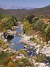
Aliso Genoese Bridge over the Bravone
As of 2021 the Bravone valley did not attract many tourists, even in the high season. It is accessible via the D16 and D116 roads. The D16 leads through the villages of Tox, Campi, Moïta and Matra on the northeast side of the valley. About 1 kilometre (0.62mi) after Matra there is a lookout point from which a 20-minute hike along a trail leads down to the magnificent Genoese bridge of Aliso. About 4 kilometres (2.5mi) above the lookout point the road crosses to the west of the river.[3] A five-minute walk upstream of the bridge along the river leads to the Bravone waterfall, set in an ancient forest, which falls into a large, deep basin.[4] On the southwest side villages include Poggio, the charming hamlet of Pianelluccio and Ampriani, a hilltop village.[3]
Water quality
In the 1980s there were plans to build a rockfill dam on the Bravone. It would have covered 68 hectares (170 acres) and contained 1,650,000 cubic metres (58,000,000cuft) of water for use in irrigating 5,000 hectares (12,000 acres) of land in the eastern plain of Corsica. However, it was found that the river's waters were significantly contaminated by arsenic and antimony, so the project was abandoned. The contamination was due to intensive exploitation of an arsenic mine at the start of the 20th century on the banks of the Presa tributary near the village of Matra. Although levels of contamination drop further downstream, even at its mouth it is three times higher than is allowed by French and European regulations. The fish in the river are not safe to eat.[5]
Hydrology
Measurements of the river flow were taken at the Tallone [Moulin de Granagiu] station from 1961 to 1999. The watershed above this station covers 66.5 square kilometres (25.7sqmi). Annual precipitation was calculated as 389 millimetres (15.3in). The average flow of water throughout the year was 0.816 cubic metres per second (28.8cuft/s).[6]
Average flow (cubic meters per second) by month for the period 1961 to 1999[6]
Month
Flow
Jan
1.200
Feb
1.700
Mar
1.360
Apr
1.270
May
0.787
Jun
0.440
Jul
0.284
Aug
0.226
Sep
0.290
Oct
0.462
Nov
0.570
Dec
1.270
Tributaries
The following streams (ruisseaux) are tributaries of the Bravone (ordered by length) and sub-tributaries:[1]
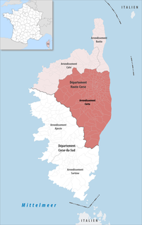
The arrondissement of Corte is an arrondissement of France in the Haute-Corse department in the territorial collectivity of Corsica. It has 158 communes. Its population is 58,800 (2016), and its area is 2,853.4 km2 (1,101.7 sq mi).
Aléria is a commune in the Haute-Corse department of France on the island of Corsica, former bishopric and present Latin Catholic titular see. It includes the easternmost point in Metropolitan France.
Ampriani is a commune in the Haute-Corse department on the island of Corsica, France.
Moïta is a commune in the Haute-Corse department, on the island of Corsica, France.
The Tavignano is a river on the island of Corsica, France.
The canton of Ghisonaccia is an administrative division of the Haute-Corse department, southeastern France. It was created at the French canton reorganisation which came into effect in March 2015. Its seat is in Ghisonaccia.
The Tartagine is a river in the department of Haute-Corse, Corsica, France. It flows through the Monte Cinto massif. It is a tributary of the Asco, which in turn is a tributary of the Golo.
The Casaluna is a small river in the department of Haute-Corse, Corsica, France. It is a tributary of the Golo.
The Solenzara is a small coastal river in the departments of Corse-du-Sud and Haute-Corse, Corsica, France.
The Buccatoggio, or Bucatoggio, is a small coastal river in the department of Haute-Corse, Corsica, France. It rises in the Monte San Petrone massif and flows into the Tyrrhenian Sea on the east of the island.
The Fium'Alto is a small coastal river in the department of Haute-Corse, Corsica, France.
The Baraci is a small coastal river in the southwest of the department of Corse-du-Sud, Corsica, France.
The Fiumicicoli is a river in the southeast of the department of Corse-du-Sud, Corsica, France. It is a tributary of the river Rizzanese.
The Ese is a river in the department of Corse-du-Sud, Corsica, France. It is a tributary of the Prunelli river, which it joins in the Lac de Tolla.
The Ortolo is a coastal river in the southwest of the department of Corse-du-Sud, Corsica, France. It is dammed to store water for irrigation.
The Cruzzini is a river in the center of the department of Corse-du-Sud, Corsica, France. It is a tributary of the river Liamone. The valley is isolated, heavily wooded, and surrounded by high and steep mountains. There is little tourism, and the population is poorer and older than in the island as a whole.
The Guagno is a river in the north of the department of Corse-du-Sud, Corsica, France. It is a tributary of the river Liamone.
The Porto is a small coastal river in the northwest of the department of Corse-du-Sud, Corsica, France.
The Seccu River is a small coastal river in the department of Haute-Corse, Corsica, France.
The Olmeta is a small coastal stream in the department of Haute-Corse, Corsica, France. It enters the Mediterranean Sea from the west of the Cap Corse peninsula.
This page is based on this Wikipedia article Text is available under the CC BY-SA 4.0 license; additional terms may apply. Images, videos and audio are available under their respective licenses.