Course
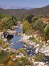
The Fango is 22.72 kilometres (14.12 mi) long. It crosses the communes of Galéria and Manso. [1] The watershed of the river covers 235 kilometres (146 mi). It extends from Galéria to the Paglia Orba and from the Col de Marsolino to the Col de Palmarella.
The Fango rises in the commune of Manso to the west of the 2,335 metres (7,661 ft) Capo Tafonatu. Its tributaries drain the ridge line in the Monte Cinto massif of which the highest point is the 2,556 metres (8,386 ft) Punta Minuta. In its upper reaches it is called the Ruisseau de Capu di Vetto. It runs in a northwest direction past Monte-Estreino, Barghana, Manso and Tuarelli to enter the Gulf of Caléria just north of the town of Galéria. From Barghiana to the coast the D351 road follows the river.

The arrondissement of Calvi is an arrondissement of France in the Haute-Corse department in the territorial collectivity of Corsica. It has 51 communes. Its population is 29,576 (2016), and its area is 1,338.4 km2 (516.8 sq mi).

Corsica is an island in the Mediterranean Sea and one of the 18 regions of France. It is the fourth-largest island in the Mediterranean and lies southeast of the French mainland, west of the Italian Peninsula and immediately north of the Italian island of Sardinia, the nearest land mass. A single chain of mountains makes up two-thirds of the island. As of January 2024, it had a population of 355,528.

Asco is a commune in the Haute-Corse department of France on the island of Corsica.

Albertacce is a commune in the Haute-Corse department in the Corsica region of France.

The Tavignano is a river on the island of Corsica, France.

The Abatesco is a French coastal river which flows through the Haute-Corse department and empties into the Tyrrhenian Sea.

The Alesani River is a river in the Haute-Corse department in the island of Corsica, France.

The Monte Cinto massif is one of the main massifs in the island of Corsica, France, taking its name from the highest mountain in Corsica, Monte Cinto. It is the northernmost and highest of the four massifs that form the spine of the island. The massif is mostly in the Haute-Corse department, but the southwest of the massif is in the Corse-du-Sud department.

The Regino River is a small coastal river in the department of Haute-Corse, Corsica, France.

The Tagnone is a small river in the department of Haute-Corse, Corsica, France. It is a tributary of the river Tavignano.

The Sisco is a small coastal stream in the department of Haute-Corse, Corsica, France. It enters the Tyrrhenian Sea from the east of the Cap Corse peninsula.

The Prunelli is a small coastal river in the department of Corse-du-Sud, Corsica, France. It flows into the Golfe d'Ajaccio on the Mediterranean Sea.

The Ese is a river in the department of Corse-du-Sud, Corsica, France. It is a tributary of the Prunelli river, which it joins in the Lac de Tolla.

The Ortolo is a coastal river in the southwest of the department of Corse-du-Sud, Corsica, France. It is dammed to store water for irrigation.

The Sagone is a coastal river in the northwest of the department of Corse-du-Sud, Corsica, France.

The Porto is a small coastal river in the northwest of the department of Corse-du-Sud, Corsica, France.

The Guadu Grande is a small coastal stream in the department of Haute-Corse, Corsica, France. It enters the Mediterranean Sea from the west of the Cap Corse peninsula.

The Col de Marsolino is a mountain pass in the Haute-Corse department of Corsica, France. The pass is in the west of the Monte Cinto massif. It connects Calvi and Calenzana to Galéria. Its low altitude allows it to be open almost all year round.

The Paglia Orba is a mountain peak in the Monte Cinto massif in Corsica. It rises to an altitude of 2,525 metres (8,284 ft), between the valleys of the Golo and the Cavicchia. Relatively isolated, this peak, notable for its characteristic tooth-shaped silhouette, dominates the Fango Valley and the west coast of the island.

The Capu Tafunatu is a mountain in the department of Haute-Corse on the island of Corsica, France. It rises to an altitude of 2,335 metres (7,661 ft) in the Niolo piève in the northwest of the island. Located in the Monte Cintu massif near the Paglia Orba, it rises southeast of Manso on the edge of the commune of Albertacce.
This page is based on this
Wikipedia article Text is available under the
CC BY-SA 4.0 license; additional terms may apply.
Images, videos and audio are available under their respective licenses.