Setting
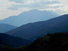
The island of Corsica essentially consists of a long chain of mountains divided into four massifs. From north to south these are the massifs of Monte Cinto, Monte Rotondo, Monte Renoso and Monte Incudine. The Monte Cinto massif is the highest at 2,706 metres (8,878 ft) of elevation, followed by the massifs of Monte Rotondo, Monte Renoso and Monte Incudine. The main peaks are Monte Cinto, Punta Minuta, Paglia Orba, Monte Padro, Monte Traunato, Monte Corona, Capu a u Ceppu and Monte Grosso. [3]
The massif is bounded by the Forêt de Bonifatu and Forêt de Tartagine Melaja to the north, the Forêt de Pineto to the east and the Forêt de Valdu Niellu to the south. It is drained by the Fango river to the west, the Tavignano to the southeast, the Golo to the east, the Asco and Tartagine to the northeast and the Figarella to the northwest.

Monte Cinto is the highest mountain on the island of Corsica, a region of France.

Asco is a commune in the Haute-Corse department of France on the island of Corsica.

Monte San Parteo is a mountain peak located in Monticello, Haute-Corse, Corsica. Situated between the valley of the River Melaja Tartagine and the valley of Fiume di Regino, the mountain rises to 1,680 metres (5,510 ft). It is part of the Monte Cinto massif.

Monte San Petrone is a mountain in the department of Haute-Corse on the island of Corsica, France. It is the highest mountain in the Monte San Petrone massif, the southernmost of the schist massifs of the northeast of the island.

Punta Artica or Monte Artica is a mountain in the department of Haute-Corse on the island of Corsica, France. It is in the Monte Rotondo massif.

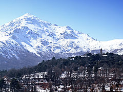
Monte Rotondo is a mountain in the department of Haute-Corse on the island of Corsica, France. At 2,622 metres (8,602 ft) it is the second highest in Corsica, after Monte Cinto. It is the highest point on the Monte Rotondo massif.

The Capu Biancu is a mountain in the department of Haute-Corse on the island of Corsica, France.

The Monte Incudine massif is a chain of mountains in the south of the island of Corsica, France. It takes its name from Monte Incudine, the highest peak.

Monte Incudine is a mountain in the department of Corse-du-Sud on the island of Corsica, France. It is the highest peak in the Monte Incudine massif.

The Asco is a small river in the department of Haute-Corse, Corsica, France. It is a tributary of the Golo. The river rises in the Monte Cinto massif among some of the highest mountains of Corsica, passes a ski resort and the old village of Asco and cuts through a dramatic 4 kilometres (2.5 mi) gorge before joining the Golo.

The Monte San Petrone massif is a chain of mountains in the northeast of the island of Corsica, France. It takes its name from Monte San Petrone, the highest peak.

The Monte Renoso massif is a chain of mountains in the south of the island of Corsica, France. It takes its name from Monte Renoso, the highest peak.
The Monte Rotondo massif is a chain of mountains on the southern side of Corsica, France. It takes its name from Monte Rotondo, the highest peak.

Lac du Monte Tignoso is a small lake in the Monte Renoso massif in the Corse-du-Sud department of France.

Monte d'Oro is a mountain in the department of Haute-Corse on the island of Corsica, France, one of the highest on the island. It is in the south of the Monte Rotondo massif, but is sometimes considered the summit of its own massif, the Monte d'Oro massif.

Capo al Berdato is a mountain in the department of Haute-Corse on the island of Corsica, France. It is in the Monte Cinto massif.

Monte Padro is a 2,389 metres (7,838 ft) mountain in the department of Haute-Corse on the island of Corsica, France. It is in the Monte Cinto massif.
This page is based on this
Wikipedia article Text is available under the
CC BY-SA 4.0 license; additional terms may apply.
Images, videos and audio are available under their respective licenses.