Cima di e Follicie

Last updated
Cima di e Follicie
Cima a e Follicce.JPG
View of the summit
Highest point
Elevation 1,324 m (4,344 ft)  OOjs UI icon edit-ltr-progressive.svg
Prominence 956 m (3,136 ft)
Parent peak Monte Asto
Isolation 29.21 km (18.15 mi)
Coordinates 42°49′41″N9°23′09″E / 42.82806°N 9.38583°E / 42.82806; 9.38583 Coordinates: 42°49′41″N9°23′09″E / 42.82806°N 9.38583°E / 42.82806; 9.38583
Geography
Corse region relief location map.jpg
Red triangle with thick white border.svg
Cima di e Follicie
CountryFrance
Department Haute-Corse
Geology
Formed by Fold and thrust belt
Orogeny Alpine orogeny
Age of rock Cretaceous
Type of rock Ophiolite

Cima di e Follicie is a mountain in the department of Haute-Corse on the island of Corsica, France. It is in the Monte Stello massif on Cap Corse.

Contents

Location

The peak of Cima di e Follicie is just northeast of the intersection of the boundaries of the communes of Olcani to the south, Ogliastro to the west and Sisco to the east. It is southeast of the village of Canari and west of the town of Sisco. [1]

Physical

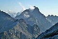
Cima di e Follicie has a prominence of 956 metres (3,136 ft) and an elevation of 1,324 metres (4,344 ft). It is isolated by 29.21 kilometres (18.15 mi) from Monte Asto to the south-southwest. [2] It is the highest peak in the Monte Stello massif, surpassing Monte Stello by 18 metres (59 ft). [3] It looks over the Albo beach and Canelle point to the west and the sea around Sisco to the east. [4]

Cime di e Follicie consists of Cretaceous ophiolites that were formed during the Alpine orogeny. [5]

Hiking

The hike from the village of Olcani climbs for almost 1,000 metres (3,300 ft). At first it follows a track that was meant to cross the cape but has never been paved, which climbs steeply at times to a small chapel in the San Giovanni pass, from where the track leads on to Sisco. A marked path leads towards the Pruberzulu rock, and from there to the summit. [4]

Notes

    1. Node: Cima di e Follicie (26862699).
    2. Cima di e Follicie, Peakbagger.
    3. Les 7 massifs corses.
    4. 1 2 Cima di e Follicie 1322m.
    5. Atlas thématique de la Corse, pp. 1, 18.

    Sources

    Related Research Articles

    <span class="mw-page-title-main">Monte San Petrone</span>

    Monte San Petrone is a mountain in the department of Haute-Corse on the island of Corsica, France. It is the highest mountain in the Monte San Petrone massif, the southernmost of the schist massifs of the northeast of the island.

    <span class="mw-page-title-main">Punta Artica</span>

    Punta Artica or Monte Artica is a mountain in the department of Haute-Corse on the island of Corsica, France. It is in the Monte Rotondo massif.

    <span class="mw-page-title-main">Monte Rotondo</span>

    Monte Rotondo is a mountain in the department of Haute-Corse on the island of Corsica, France. At 2,622 metres (8,602 ft) it is the second highest in Corsica, after Monte Cinto. It is the highest point on the Monte Rotondo massif.

    <span class="mw-page-title-main">Monte Astu</span>

    Monte Astu or Monte Asto is a mountain in the department of Haute-Corse on the island of Corsica, France.

    <span class="mw-page-title-main">Capu Biancu</span>

    The Capu Biancu is a mountain in the department of Haute-Corse on the island of Corsica, France.

    <span class="mw-page-title-main">Col de Bigorno</span> Mountain pass in Corsica, France

    The Col de Bigorno Corsican: Bocca di Bigornu), or Bigorno Pass, is a mountain pass in the Haute-Corse department of Corsica, France.

    <span class="mw-page-title-main">Monte Stello</span>

    Monte Stello is a mountain in the department of Haute-Corse on the island of Corsica, France. It is the second highest point in the Monte Stello massif, which forms the backbone of Cap Corse.

    <span class="mw-page-title-main">Monte Stello massif</span>

    The Monte Stello massif is a chain of mountains in the island of Corsica, France, that forms the spine of the northern peninsula, Cap Corse. It takes its name from Monte Stello, which was long thought to be the highest peak, but more recently it has been determined that Cima di e Follicie is the highest.

    <span class="mw-page-title-main">Col de San Colombano</span>

    Col de San Colombano is a mountain pass in Corsica.

    <span class="mw-page-title-main">Sisco (stream)</span> Stream in the department of Haute-Corse, Corsica

    The Sisco is a small coastal stream in the department of Haute-Corse, Corsica, France. It enters the Tyrrhenian Sea from the east of the Cap Corse peninsula.

    <span class="mw-page-title-main">Pietracorbara (stream)</span> River in France

    The Ruisseau de Pietracorbara is a coastal stream in the department of Haute-Corse, Corsica, France. It rises in the Monte Stello massif on Cap Corse and flows into the Tyrrhenian Sea on the east of the island.

    <span class="mw-page-title-main">Monte d'Oro</span>

    Monte d'Oro is a mountain in the department of Haute-Corse on the island of Corsica, France, one of the highest on the island. It is in the south of the Monte Rotondo massif, but is sometimes considered the summit of its own massif, the Monte d'Oro massif.

    <span class="mw-page-title-main">Col de Santo Stefano</span>

    The Col de Santo Stefano Corsican: Bocca di San Stefanu) is a mountain pass in the Haute-Corse department of Corsica, France. It is one of the main passes in Corsica, running between the massifs of Monte Stello to the north and Monte Astu to the south. It provides a route from the Saint-Florent region to the northwest and Biguglia in the eastern coastal plain.

    <span class="mw-page-title-main">Col de Teghime</span>

    The Col de Teghime is a mountain pass in the Haute-Corse department of Corsica, France. The pass is in the south of the Monte Stello massif and is one of the main passes in the island.

    <span class="mw-page-title-main">Monte Renoso</span>

    Monte Renoso is a mountain in the departments of Haute-Corse and Corse-du-Sud on the island of Corsica, France. It is the highest peak in the Monte Renoso massif.

    <span class="mw-page-title-main">Col de Prato</span>

    The Col de Prato is a mountain pass in the Haute-Corse department of Corsica, France.

    <span class="mw-page-title-main">Punta Minuta</span>

    Punta Minuta is a 2,556 metres (8,386 ft) mountain in the department of Haute-Corse on the island of Corsica, France. It is in the Monte Cinto massif.

    <span class="mw-page-title-main">Paglia Orba</span>

    The Paglia Orba is a mountain peak in the Monte Cinto massif in Corsica. It rises to an altitude of 2,525 metres (8,284 ft), between the valleys of the Golo and the Cavicchia. Relatively isolated, this peak, notable for its characteristic tooth-shaped silhouette, dominates the Fango Valley and the west coast of the island.

    <span class="mw-page-title-main">Monte Padro</span>

    Monte Padro is a 2,389 metres (7,838 ft) mountain in the department of Haute-Corse on the island of Corsica, France. It is in the Monte Cinto massif.