Monte Astu

Last updated
Monte Astu
Monte Astu.JPG
Monte Astu
Highest point
Elevation 1,535 m (5,036 ft) [1]
Prominence 1,063 m (3,488 ft)  OOjs UI icon edit-ltr-progressive.svg
Parent peak Cima à i Mori  OOjs UI icon edit-ltr-progressive.svg
Isolation 17.95 km (11.15 mi)  OOjs UI icon edit-ltr-progressive.svg
Listing Mountains of Corsica
Coordinates 42°34′52″N9°12′36″E / 42.5812°N 9.2100°E / 42.5812; 9.2100
Geography
Corse region relief location map.jpg
Red triangle with thick white border.svg
Monte Astu
CountryFrance
Department Haute-Corse

Monte Astu or Monte Asto is a mountain in the department of Haute-Corse on the island of Corsica, France.

Contents

Location

The peak is on the border between the communes of Lama and Sorio. It is to the east of the D8 road from Pietralba via Lama to Urtaca. It is the highest point of a ridge that includes the 1,509 metres (4,951 ft) Cima di Grimaseta and 1,512 metres (4,961 ft) Petra San Ghiaccu to the south and the 1,371 metres (4,498 ft) Monte a l'Alturaia, 1,299 metres (4,262 ft) Cima a Muzzelli and 1,063 metres (3,488 ft) Monte Ambrica to the north. [2] Another ridge runs eastward through the 1333 Monti di Peru, 1042 A Genucula and 717 Croce d'Aculaghja to San-Gavino-di-Tenda. [3] The Fiume di Gargalagne, a tributary of the Ostriconi, drains the west of the ridge. Streams from the southeast of the ridge feed the Fiumi Raghiunti, the upper section of the Aliso River. [2]

Physical

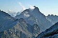
Monte Asto has an elevation of 1,535 metres (5,036 ft) and clean prominence of 1,063 metres (3,488 ft). It is isolated by 17.96 kilometres (11.16 mi) from its nearest higher neighbour, Cima a i Mori to the south of southwest. [4]

Monte Astu is the highest point in the Tenda massif between Saint-Florent and L'Île-Rousse in Haute-Corse. This is a granitic mole partially detached from its mica schist encasement which still remains on its periphery and on its roof. [5]

Hiking

The route to the summit from Lama is 12.8 kilometres (8.0 mi) there and back, with a vertical of 1,043 metres (3,422 ft). It is considered difficult, and takes about six hours. [3] The path winds through Corsican maquis shrubland along a marked path past the Refuge de Prunincu to the ridge overlooking the Puleghio ravine. ffA small climb across riprap is needed to reach the summit, not advised for people with vertigo. [6]

From the summit there is a beautiful panorama over northern Corsica, including the Agriates Desert, the Monte Cinto massif, Cap Corse and the Tuscan Archipelago. [3] The view includes the eastern plain, the Saint-Florent bay to the north and L'Île-Rousse to the west. [6]

Notes

    1. "Topographic map of Monte Astu". opentopomap.org. Retrieved 2023-06-16.
    2. 1 2 Node: Monte Astu (26863790).
    3. 1 2 3 Rando 17 : Monte Astu.
    4. Monte Asto, France, Peakbagger.
    5. Lahondere, Rossi & Lahondere 1999, p. 28.
    6. 1 2 Le Monte Astu à partir de Lama.

    Sources

    Related Research Articles

    <span class="mw-page-title-main">Arrondissement of Calvi</span> Arrondissement in Corsica, France

    The arrondissement of Calvi is an arrondissement of France in the Haute-Corse department in the territorial collectivity of Corsica. It has 51 communes. Its population is 29,576 (2016), and its area is 1,338.4 km2 (516.8 sq mi).

    <span class="mw-page-title-main">Barbaggio</span> Commune in Corsica, France

    Barbaggio is a commune in the French department of Haute-Corse on the island of Corsica. It is known for its wine, its scenery, and the prehistoric site of Strette.

    <span class="mw-page-title-main">Rapale</span> Commune in Corsica, France

    Rapale is a commune in the French Department of Haute-Corse on the island of Corsica.

    <span class="mw-page-title-main">Monte San Petrone</span>

    Monte San Petrone is a mountain in the department of Haute-Corse on the island of Corsica, France. It is the highest mountain in the Monte San Petrone massif, the southernmost of the schist massifs of the northeast of the island.

    <span class="mw-page-title-main">Punta Artica</span>

    Punta Artica or Monte Artica is a mountain in the department of Haute-Corse on the island of Corsica, France. It is in the Monte Rotondo massif.

    <span class="mw-page-title-main">Monte Rotondo</span>

    Monte Rotondo is a mountain in the department of Haute-Corse on the island of Corsica, France. At 2,622 metres (8,602 ft) it is the second highest in Corsica, after Monte Cinto. It is the highest point on the Monte Rotondo massif.

    <span class="mw-page-title-main">Capu Biancu</span>

    The Capu Biancu is a mountain in the department of Haute-Corse on the island of Corsica, France.

    <span class="mw-page-title-main">Col de Bigorno</span> Mountain pass in Corsica, France

    The Col de Bigorno Corsican: Bocca di Bigornu), or Bigorno Pass, is a mountain pass in the Haute-Corse department of Corsica, France.

    <span class="mw-page-title-main">Monte Stello</span>

    Monte Stello is a mountain in the department of Haute-Corse on the island of Corsica, France. It is the second highest point in the Monte Stello massif, which forms the backbone of Cap Corse.

    <span class="mw-page-title-main">Monte Stello massif</span>

    The Monte Stello massif is a chain of mountains in the island of Corsica, France, that forms the spine of the northern peninsula, Cap Corse. It takes its name from Monte Stello, which was long thought to be the highest peak, but more recently it has been determined that Cima di e Follicie is the highest.

    <span class="mw-page-title-main">Cima di e Follicie</span>

    Cima di e Follicie is a mountain in the department of Haute-Corse on the island of Corsica, France. It is in the Monte Stello massif on Cap Corse.

    <span class="mw-page-title-main">Monte Astu massif</span>

    The Monte Astu massif is a chain of mountains in the northeast of the island of Corsica, France. It takes its name from Monte Astu, the highest peak.

    <span class="mw-page-title-main">Ostriconi</span> River in the department of Haute-Corse, Corsica

    The Ostriconi is a small coastal river in the department of Haute-Corse, Corsica, France.

    The Buggiu or Valdolese, Vughio is a small coastal river in the department of Haute-Corse, Corsica, France. It flows into the Golfe de Saint-Florent in the north of the island. The estuary at its mouth has ecological value.

    <span class="mw-page-title-main">Monte d'Oro</span>

    Monte d'Oro is a mountain in the department of Haute-Corse on the island of Corsica, France, one of the highest on the island. It is in the south of the Monte Rotondo massif, but is sometimes considered the summit of its own massif, the Monte d'Oro massif.

    <span class="mw-page-title-main">Col de Santo Stefano</span>

    The Col de Santo Stefano Corsican: Bocca di San Stefanu) is a mountain pass in the Haute-Corse department of Corsica, France. It is one of the main passes in Corsica, running between the massifs of Monte Stello to the north and Monte Astu to the south. It provides a route from the Saint-Florent region to the northwest and Biguglia in the eastern coastal plain.

    <span class="mw-page-title-main">Col de Teghime</span>

    The Col de Teghime is a mountain pass in the Haute-Corse department of Corsica, France. The pass is in the south of the Monte Stello massif and is one of the main passes in the island.

    <span class="mw-page-title-main">Monte Renoso</span>

    Monte Renoso is a mountain in the departments of Haute-Corse and Corse-du-Sud on the island of Corsica, France. It is the highest peak in the Monte Renoso massif.

    <span class="mw-page-title-main">Col de Sainte-Marie (Corsica)</span>

    The Col de Sainte-Marie or Col de Pietralba is a mountain pass in the Haute-Corse department of Corsica, France. It is between the Monte Astu massif to the east and the Monte Cinto massif to the west. It leads from the Ostriconi valley to the northwest to the Tartagine valley, which leads to the east coast.

    <span class="mw-page-title-main">Monte Padro</span>

    Monte Padro is a 2,389 metres (7,838 ft) mountain in the department of Haute-Corse on the island of Corsica, France. It is in the Monte Cinto massif.