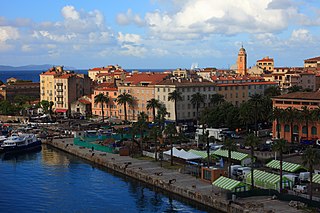
Ajaccio is a French commune, prefecture of the department of Corse-du-Sud, and head office of the Collectivité territoriale de Corse. It is also the largest settlement on the island. Ajaccio is located on the west coast of the island of Corsica, 210 nautical miles (390 km) southeast of Marseille.

Bastia is a commune in the department of Haute-Corse, France located in the north-east of the island of Corsica at the base of Cap Corse. It also has the second-highest population of any commune on the island after Ajaccio and is the capital of the Bagnaja region and of the department.

Porto-Vecchio is a commune in the French department of Corse-du-Sud, on the island of Corsica.

The arrondissement of Bastia is an arrondissement of France in the Haute-Corse department in the territorial collectivity of Corsica. It has 27 communes. Its population is 87,776 (2016), and its area is 473.8 km2 (182.9 sq mi).

The arrondissement of Calvi is an arrondissement of France in the Haute-Corse department in the territorial collectivity of Corsica. It has 51 communes. Its population is 29,576 (2016), and its area is 1,338.4 km2 (516.8 sq mi).

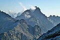
Corsica is an island in the Mediterranean Sea and one of the 18 regions of France. It is the fourth-largest island in the Mediterranean and lies southeast of the French mainland, west of the Italian Peninsula and immediately north of the Italian island of Sardinia, which is the land mass nearest to it. A single chain of mountains makes up two-thirds of the island. In 2018, it had a population of 338,550.

Asco(in Corsican Ascu, pronounced [ˈaːs.ku]) is a commune in the Haute-Corse department of France on the island of Corsica.

Algajola is a commune in the Haute-Corse department of France on the island of Corsica.

Antisanti is a commune in the Haute-Corse department of France on the island of Corsica.

Barbaggio is a commune in the French department of Haute-Corse on the island of Corsica. It is known for its wine, its scenery, and the prehistoric site of Strette.
Rapale is a commune in the French Department of Haute-Corse on the island of Corsica.
The Canton of La Conca-d'Oro is a former canton of the arrondissement of Bastia, in the Haute-Corse department, France. It was created 18 August 1973 by the decree 73-825. It was disbanded following the French canton reorganisation which came into effect in March 2015. It consisted of 8 communes:

Beth Meir Synagogue of Bastia is a Jewish Synagogue located at 3 Rue du Castagno in Bastia, on the island of Corsica. It is an Orthodox synagogue and a member of the Israelite Central Consistory of France.

The Agriates Desert or the Agriates is an area of Corsica split between the micro-regions of Balagne and Nebbio in Haute-Corse.

The Col de Bigorno Corsican: Bocca di Bigornu), or Bigorno Pass, is a mountain pass in the Haute-Corse department of Corsica, France.

Lac de Padula is a reservoir in the Haute-Corse department of France, on the island of Corsica. It was built to supply water for irrigation and firefighting, but now also provides drinking water during the summer tourist peak.

Col de San Colombano is a mountain pass in Corsica.

The Col Saint-Antoine, or Saint-Antoine Pass, is a mountain pass in the Haute-Corse department of Corsica, France. It is one of the main passes in the island of Corsica. It rises to 687 metres (2,254 ft).

The Col de Santo Stefano Corsican: Bocca di San Stefanu) is a mountain pass in the Haute-Corse department of Corsica, France. It is one of the main passes in Corsica, running between the massifs of Monte Stello to the north and Monte Astu to the south. It provides a route from the Saint-Florent region to the northwest and Biguglia in the eastern coastal plain.

The Col de Marsolino is a mountain pass in the Haute-Corse department of Corsica, France. The pass is in the west of the Monte Cinto massif. It connects Calvi and Calenzana to Galéria. Its low altitude allows it to be open almost all year round.
This page is based on this
Wikipedia article Text is available under the
CC BY-SA 4.0 license; additional terms may apply.
Images, videos and audio are available under their respective licenses.