Geography
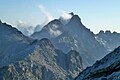
The Monte Stello massif constitutes the mountain spine of Cap Corse, at the northeastern end of the island. Of the mountains, Cima di e Follicie surpasses Monte Stello by 15 metres (49 ft) to reach 1,322 metres (4,337 ft) in height. The Col de Santo Stefano, or Santo Stefano pass, provides a route from the Mediterranean coast to the Tyrrhenian coast of Corsica. It divides the Monte Stello massif from the Monte Astu massif, both part of "Schistose Corsica" in the northeast of the island. The Lugo or Campodata stream rises on the western slope of the pass, a tributary of the Aliso River, and the Bevinco river flows through the Lancone gorge on the eastern side. The massif stretches over 40 kilometres (25 mi) from north to south, from the tip of Cap Corse to the Col de Santo Stefano.

Barbaggio is a commune in the French department of Haute-Corse on the island of Corsica. It is known for its wine, its scenery, and the prehistoric site of Strette.

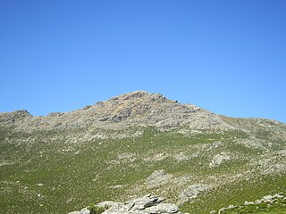
Monte San Petrone is a mountain in the department of Haute-Corse on the island of Corsica, France. It is the highest mountain in the Monte San Petrone massif, which is the southernmost of the schist massifs in the northeast of the island.

Monte Rotondo is a mountain in the department of Haute-Corse on the island of Corsica, France. At 2,622 metres (8,602 ft) it is the second highest in Corsica, after Monte Cinto. It is the highest point on the Monte Rotondo massif.

Monte Astu or Monte Asto is a mountain in the department of Haute-Corse on the island of Corsica, France.

The Capu Biancu is a mountain in the department of Haute-Corse on the island of Corsica, France.

The Monte Cinto massif is one of the main massifs in the island of Corsica, France, taking its name from the highest mountain in Corsica, Monte Cinto. It is the northernmost and highest of the four massifs that form the spine of the island. The massif is mostly in the Haute-Corse department, but the southwest of the massif is in the Corse-du-Sud department.

The Col de Bigorno Corsican: Bocca di Bigornu), or Bigorno Pass, is a mountain pass in the Haute-Corse department of Corsica, France.
Monte Stello is a mountain in the department of Haute-Corse on the island of Corsica, France. It is the second highest point in the Monte Stello massif, which forms the backbone of Cap Corse.

Cima di e Follicie is a mountain in the department of Haute-Corse on the island of Corsica, France. It is in the Monte Stello massif on Cap Corse.

Monte Incudine is a mountain in the department of Corse-du-Sud on the island of Corsica, France. It is the highest peak in the Monte Incudine massif.

Col de San Colombano is a mountain pass in Corsica.

The Ruisseau de Pietracorbara is a coastal stream in the department of Haute-Corse, Corsica, France. It rises in the Monte Stello massif on Cap Corse and flows into the Tyrrhenian Sea on the east of the island.

The Col Saint-Antoine, or Saint-Antoine Pass, is a mountain pass in the Haute-Corse department of Corsica, France. It is one of the main passes in the island of Corsica. It rises to 687 metres (2,254 ft).

Monte d'Oro is a mountain in the department of Haute-Corse on the island of Corsica, France, one of the highest on the island. It is in the south of the Monte Rotondo massif, but is sometimes considered the summit of its own massif, the Monte d'Oro massif.

The Col de Santo Stefano Corsican: Bocca di San Stefanu) is a mountain pass in the Haute-Corse department of Corsica, France. It is one of the main passes in Corsica, running between the massifs of Monte Stello to the north and Monte Astu to the south. It provides a route from the Saint-Florent region to the northwest and Biguglia in the eastern coastal plain.
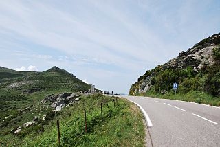
The Col de Teghime is a mountain pass in the Haute-Corse department of Corsica, France. The pass is in the south of the Monte Stello massif and is one of the main passes in the island.

The Col de Marsolino is a mountain pass in the Haute-Corse department of Corsica, France. The pass is in the west of the Monte Cinto massif. It connects Calvi and Calenzana to Galéria. Its low altitude allows it to be open almost all year round.

The Col de Prato is a mountain pass in the Haute-Corse department of Corsica, France.

The Col de Sainte-Marie or Col de Pietralba is a mountain pass in the Haute-Corse department of Corsica, France. It is between the Monte Astu massif to the east and the Monte Cinto massif to the west. It leads from the Ostriconi valley to the northwest to the Tartagine valley, which leads to the east coast.

The Paglia Orba is a mountain peak in the Monte Cinto massif in Corsica. It rises to an altitude of 2,525 metres (8,284 ft), between the valleys of the Golo and the Cavicchia. Relatively isolated, this peak, notable for its characteristic tooth-shaped silhouette, dominates the Fango Valley and the west coast of the island.