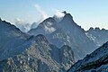
Topography
The Col de San Quilico is located at an altitude of 559 metres (1,834 ft) below the ridge line of a mountain range oriented from west to east, connecting the 1,951 metres (6,401 ft) Pinerole to the west to the 1,473 metres (4,833 ft) Punta di l'Ernella to the east. The ridge runs through via the Lorca territorial forest and may also be crossed by the 654 metres (2,146 ft) Bocca d'Ominanda and the 811 metres (2,661 ft) Pinzalaccio. A large part of the ridge line defines the border between the municipalities of Soveria and Tralonca.
The section of the mountain range holding the San Quilico pass divides the central depression or furrow of the island into two zones:
- to the north, the Ponte-Leccia basin;
- to the south, the Cortenais.
The Col de San Quilico connects the Golo valley, Bastia and the Balagne region to the north, with the Centre Corse (Centru di Corsica) to the south, the Tavignano valley and the east coast of the island, and (beyond the Col de Vizzavona) to Ajaccio and the west coast.
In the immediate environment are:
- to the north, the valley of the Ruisseau de Forcalello [2] (or Ruisseau de Santa Maria, as it is called further downstream), a tributary of the Ruisseau de Sumano, [3] a tributary of the Golo river;
- to the south, the valley of the Ruisseau de San Quilico [4] (or Ruisseau de Bistuglio), a tributary of the Tavignano river near the town of Corte.
On the northern slope, the plant cover is made up of groves of holm oaks and cork oaks, more verdant than on the south side, where only low and sparse maquis grows.
History
San Quilico is a road pass where the N 193 and D41 roads meet. It owes its name to a sanctuary further north in the town of Soveria.
In the 1880s, a railway tunnel 500 meters long was bored at an average altitude of 495 metres (1,624 ft) under the pass as part of the new Ajaccio – Bastia line, removing the obstacle of San Quilico.
In 1996, the Corte diversion was created. In 1998–1999, a 280 metres (920 ft) road tunnel was drilled under the San Quilico pass, above the railway tunnel, for the new route of the former national road 193. The “Restaurant du Col” at the pass had to close its doors.
In 2002, the new Corte - Soveria link was opened to traffic, including a tunnel and straightening of the tortuous section passing through Bistuglio and the San Quilico pass.
On January 30, 2014, the former national road 193 passing through the pass officially took the name of T203. It become a ramp to territorial road 20 which serves the hamlet of Bistuglio. The first section of the D41 road at the pass remains, despite the opening of a new access to it 300 metres (980 ft) after the southern exit of the road tunnel.

Aiti is a commune in the Haute-Corse department of France on the island of Corsica.

Chemins de fer de la Corse (CFC) is the name of the regional rail network serving the French island of Corsica. It is centred on the town of Ponte Leccia, from which three main lines radiate to Ajaccio, Bastia, and Calvi. The section following the northwest coastline between L'Île-Rousse and Calvi, known as the Balagne line, gives access to many beaches and is very popular with tourists.

The Golo is the longest river on the island of Corsica, France, at 89.4 kilometres (55.6 mi)

Asco(in Corsican Ascu, pronounced [ˈaːs.ku]) is a commune in the Haute-Corse department of France on the island of Corsica.

Morosaglia is a commune in the Haute-Corse department of France on the island of Corsica. Since 2015, it is the seat of the canton of Golo-Morosaglia.

Ponte Leccia is a French village, part of the municipality (commune) of Morosaglia, in the department of Haute-Corse, Corsica. Its name in Corsican language is U Ponte à a Leccia.

The Gravona is a river on the island of Corsica, France. It flows from the center of the island southwest to the Gulf of Ajaccio. Its entire course is in the Corse-du-Sud Department of France. It is 46.4 km (28.8 mi) long. The Gravona Valley conducts the main highway, Route N193, from the capital city, Ajaccio, to the Col de Vizzavona, where it goes through the pass and down to Corte and Bastia. At its upper end the Gravona is a crystal-clear mountain stream cascading over falls and rapids into trout-filled pools. At its lower end nearly all of the Gravona's flow serves to water the densely urban area of Ajaccio.
Col de Vizzavona 1,163 m (3,816 ft) is a mountain pass at the centre of the French island of Corsica.
The railways in Corsica are metre gauge and are operated by Chemins de fer de la Corse. A list of stations follows.

The Liamone river is a river of Corsica, France. The river gave its name to the former French department of Liamone. In antiquity, it bore the Latin name Circidius.

Monte San Petrone is a mountain in the department of Haute-Corse on the island of Corsica, France. It is the highest mountain in the Monte San Petrone massif, the southernmost of the schist massifs of the northeast of the island.

The Col de Bigorno Corsican: Bocca di Bigornu), or Bigorno Pass, is a mountain pass in the Haute-Corse department of Corsica, France.

Lac de Calacuccia is a reservoir in the Haute-Corse department of France formed by damming the Golo river. It provides hydroelectric power and water for irrigation in the dry season.

Col de San Colombano is a mountain pass in Corsica.

The Restonica is a small river in the department of Haute-Corse, Corsica, France. It is a tributary of the river Tavignano. The river has a steep and rocky course with many pools and waterfalls. The valley contains two lakes, and is a popular tourist destination.

The Col Saint-Antoine, or Saint-Antoine Pass, is a mountain pass in the Haute-Corse department of Corsica, France. It is one of the main passes in the island of Corsica. It rises to 687 metres (2,254 ft).

The Col de Santo Stefano Corsican: Bocca di San Stefanu) is a mountain pass in the Haute-Corse department of Corsica, France. It is one of the main passes in Corsica, running between the massifs of Monte Stello to the north and Monte Astu to the south. It provides a route from the Saint-Florent region to the northwest and Biguglia in the eastern coastal plain.

The Col de Marsolino is a mountain pass in the Haute-Corse department of Corsica, France. The pass is in the west of the Monte Cinto massif. It connects Calvi and Calenzana to Galéria. Its low altitude allows it to be open almost all year round.

The Col de Prato is a mountain pass in the Haute-Corse department of Corsica, France.

The Col de Sainte-Marie or Col de Pietralba is a mountain pass in the Haute-Corse department of Corsica, France. It is between the Monte Astu massif to the east and the Monte Cinto massif to the west. It leads from the Ostriconi valley to the northwest to the Tartagine valley, which leads to the east coast.
This page is based on this
Wikipedia article Text is available under the
CC BY-SA 4.0 license; additional terms may apply.
Images, videos and audio are available under their respective licenses.