The Col de Bigorno is a pass of the Serra di Tenda, a chain of schist mountains separating the Nebbio from the Ostriconi valley to the north, and the lower Golo valley to the south. It is on the southern secondary ridge of the Serra di Tenda, hinging at the level of the 1,372 metres (4,501ft) Monte Tassu and oriented to the east then to the northeast until the Lancone gorge. The rocks were formed in the Early Cretaceous.[1]
In an immediate environment, the section of the mountain range separates two valleys:
to the north, that of the Bussu stream, a tributary of the Bevinco river which flows into the Étang de Biguglia[2]
to the south, that of the Sretta stream, a tributary of the Sanguinelli stream which feeds the Golo[3][4]
Climate and vegetation
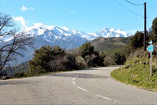
The Col de Bigorno is subject to strong north and north-westerly winds (mistral and tramontane trains). The pass is at 885 metres (2,904ft) altitude. It is snow-covered for several days in winter.
The environment is almost desert. The rocky slopes are covered with rare vegetation, a low and sparse maquis. It is in the Massif du Tenda et Monte Astu zone naturelle d'intérêt écologique, faunistique et floristique. The area is favorable to extensive livestock farming, which is likely to increase. Grazing promotes the maintenance of open environments favorable to biodiversity and the fight against fires.[5]
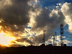
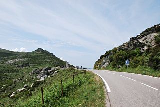
The D5 road which connects the Col de Santo Stefano to the national road 193 in Ponte-Novu, goes through the Col de Bigorno to cross the ridge line. Electricity and telecommunications pylons are installed above the D5 road.
History
Église Santa-Maria-Assunta in the Col de Bigorno
Formerly, as evidenced by the Genoese bridges in the town of Murato, the Col de Bigorno was a route for peddlers and transhumant shepherds. They also took the neighboring 1,028 metres (3,373ft) Col de Vadellaia, located on an important path linking the hamlets of Bigorno and the Nebbio and passing the Romanesque chapel of Sant 'Agostino de Locchia (around the second half of the 12th century) located at 600 metres (2,000ft) southwest of Montechiaro Tower.[lower-alpha 2][6]
Like the Tenda and Lento passes, the strategic position of the Bigorno pass has made it an important military passage and place of fighting for a very long time. Troops of various nationalities who disembarked in the Gulf of Saint-Florent crossed it and then went to the interior of the island.
In 1732, at the end of April, the imperial German troops stationed at Saint-Florent, led by Samuel von Schmettau, occupied the Nebbio then the coast to Tenda and Lento.[7]
In 1739, the count of Maillebois, at the head of the French troops of Corsica, began a campaign and decided to bear arms in the mountainous cantons of the interior. The capture of Lento and Bigorno ensured the almost complete occupation of the valley of Golo.[8] On 2 June the French maréchal de camp Du Rousset de Girenton, who left Bastia during the night, attacked the Bocca San Ghjacumu and the heights of Tenda and Lentu. Maillebois left Bastia and made his base in Costere (Campitello) where, after Tenda and Bigorno, Lento, held by Ghjacomu Paoli, capitulated on 3 June.
On 1 May 1769 Pasquale Paoli, who had established his headquarters in Murato, had his Corsican militias occupy the heights of Tenda which controlled the valleys of Aliso, Ostriconi and Golo. At dawn on 5 May Noël Jourda de Vaux and his deputy Lieutenant-General de Bourcet commanded the general offensive of the French troops. The Chevalier de Viomesnil captured Bigorno. On 8 May the Corsicans launched an assault on Lento and Bocca San Ghjacumu. They unsettled the French and felt that victory was within their reach, but Paoli, who was overseeing operations from a height on the other side of the Golu, neglected to protect the flanks. Two French columns came out of Bigorno and Canavaggia. The Corsicans, taken from the rear, were forced into a disorderly retreat towards the Golo bridge under the plunging fire of French arms. On the other side of the Golo, Gentili, obeying the orders received, refused the passage of the bridge until Paoli ordered him to withdraw. The combat ended in the greatest confusion when night fell.[7]
Notes
↑ Thymus herba-barona is not found in France except in Corsica, where it is called thym de Corse.
↑ The tower of Montechiaro is mentioned for the first time in 1247. It belonged to a small lineage bearing the same name as the fortification.
The Golo is the longest river on the island of Corsica, France, at 89.4 kilometres (55.6 mi)
Asco is a commune in the Haute-Corse department of France on the island of Corsica.
Barbaggio is a commune in the French department of Haute-Corse on the island of Corsica. It is known for its wine, its scenery, and the prehistoric site of Strette.
Rapale is a commune in the French Department of Haute-Corse on the island of Corsica.
The Bevinco is a small river in the northeast of the Haute-Corse department on the French island of Corsica. It is the main tributary of the Étang de Biguglia, the largest wetland in Corsica.
Monte San Petrone is a mountain in the department of Haute-Corse on the island of Corsica, France. It is the highest mountain in the Monte San Petrone massif, the southernmost of the schist massifs of the northeast of the island.
Monte Astu or Monte Asto is a mountain in the department of Haute-Corse on the island of Corsica, France.
The Monte Stello massif is a chain of mountains in the island of Corsica, France, that forms the spine of the northern peninsula, Cap Corse. It takes its name from Monte Stello, which was long thought to be the highest peak, but more recently it has been determined that Cima di e Follicie is the highest.
The Monte Astu massif is a chain of mountains in the northeast of the island of Corsica, France. It takes its name from Monte Astu, the highest peak.
Lac de Calacuccia is a reservoir in the Haute-Corse department of France formed by damming the Golo river. It provides hydroelectric power and water for irrigation in the dry season.
The Monte San Petrone massif is a chain of mountains in the northeast of the island of Corsica, France. It takes its name from Monte San Petrone, the highest peak.
The Fango is a small coastal river in the department of Haute-Corse, Corsica, France. The Fango Valley was designated a biosphere reserve in 1977. It holds flora and fauna representative of all regions of Corsica from the coast to the highest mountains.
The Col Saint-Antoine, or Saint-Antoine Pass, is a mountain pass in the Haute-Corse department of Corsica, France. It is one of the main passes in the island of Corsica. It rises to 687 metres (2,254 ft).
The Col de Santo Stefano Corsican: Bocca di San Stefanu) is a mountain pass in the Haute-Corse department of Corsica, France. It is one of the main passes in Corsica, running between the massifs of Monte Stello to the north and Monte Astu to the south. It provides a route from the Saint-Florent region to the northwest and Biguglia in the eastern coastal plain.
The Col de Teghime is a mountain pass in the Haute-Corse department of Corsica, France. The pass is in the south of the Monte Stello massif and is one of the main passes in the island.
The Col de Marsolino is a mountain pass in the Haute-Corse department of Corsica, France. The pass is in the west of the Monte Cinto massif. It connects Calvi and Calenzana to Galéria. Its low altitude allows it to be open almost all year round.
The Col de Prato is a mountain pass in the Haute-Corse department of Corsica, France.
The Col de Sainte-Marie or Col de Pietralba is a mountain pass in the Haute-Corse department of Corsica, France. It is between the Monte Astu massif to the east and the Monte Cinto massif to the west. It leads from the Ostriconi valley to the northwest to the Tartagine valley, which leads to the east coast.
The Paglia Orba is a mountain peak in the Monte Cinto massif in Corsica. It rises to an altitude of 2,525 metres (8,284 ft), between the valleys of the Golo and the Cavicchia. Relatively isolated, this peak, notable for its characteristic tooth-shaped silhouette, dominates the Fango Valley and the west coast of the island.
The Col de San Quilico or collo di San Quilico is a mountain pass in the Haute-Corse department of Corsica, France. It is a road pass on Territorial Route 20, between Corte and Ponte Leccia (Morosaglia).
This page is based on this Wikipedia article Text is available under the CC BY-SA 4.0 license; additional terms may apply. Images, videos and audio are available under their respective licenses.