Location
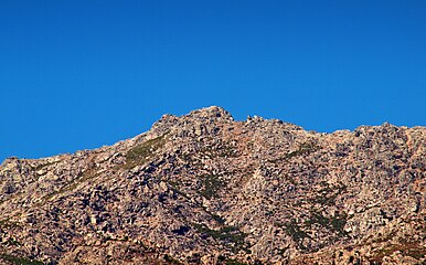
The Monte Astu massif has a main chain, the Serra di Tenda, and two secondary chains. The Serra di Tenda has all the highest peaks in the massif. It separates the Nebbio from the Ostriconi valley.
Part of the massif covering 6,159 hectares (15,220 acres) has been designated a Zone naturelle d'intérêt écologique, faunistique et floristique (ZNIEFF). Elevations range from 400 to 1,535 metres (1,312 to 5,036 ft). The ZNIEFF extends along the ridge from Monte Filetto (842 m) to the Rocher de Pietrapolo (1104 m). This main chain changes direction at Monte Tassu, where a secondary ridge line oriented to the north emerges, comprising Monte Maggiore (1102 m) and Monte Pietrapolo (1104 m). The main ridge line has eight peaks that exceed 1,100 m: Cima di Grimaseta: 1,509 metres (4,951 ft), Monte Asto: 1,535 metres (5,036 ft), Cima to i Muzzelli: 1,299 metres (4,262 ft), Punta di Paganella: 1,426 metres (4,678 ft), Monte Reghia di Pozzo: 1,469 metres (4,820 ft), Monte Sant'Angelo: 1,389 metres (4,557 ft), Monte Tassu: 1,372 metres (4,501 ft), Rocher de Pietrapolo: 1,104 metres (3,622 ft).

Monte Rosa is a mountain massif in the eastern part of the Pennine Alps, on the border between Italy and Switzerland (Valais). The highest peak of the massif, amongst several peaks of over 4,000 m (13,000 ft), is the Dufourspitze, the second highest mountain in the Alps and western Europe, after Mont Blanc. The east face of the Monte Rosa towards Italy has a height of about 2,400 metres (7,900 ft) and is the highest mountain wall of the Alps.

The Dom is a mountain of the Pennine Alps, located between Randa and Saas-Fee in the canton of Valais in Switzerland. With a height of 4,546 m (14,915 ft), it is the seventh highest summit in the Alps, overall. Based on prominence, it can be regarded as the third highest mountain in the Alps, and the second highest in Switzerland, after Monte Rosa. The Dom is the main summit of the Mischabel group, which is the highest massif lying entirely in Switzerland.

The Alps form a large mountain range dominating Central Europe, including parts of Italy, France, Switzerland, Liechtenstein, Austria, Slovenia, Germany and Hungary.

Bastelica is a commune in the Corse-du-Sud department of France on the island of Corsica.

Barbaggio is a commune in the French department of Haute-Corse on the island of Corsica. It is known for its wine, its scenery, and the prehistoric site of Strette.
Rapale is a commune in the French Department of Haute-Corse on the island of Corsica.

The Agriates Desert or the Agriates is an area of Corsica split between the micro-regions of Balagne and Nebbio in Haute-Corse.

The Abatesco is a French coastal river which flows through the Haute-Corse department and empties into the Tyrrhenian Sea.

Monte Astu or Monte Asto is a mountain in the department of Haute-Corse on the island of Corsica, France.

The Col de Bigorno Corsican: Bocca di Bigornu), or Bigorno Pass, is a mountain pass in the Haute-Corse department of Corsica, France.

The Monte Stello massif is a chain of mountains in the island of Corsica, France, that forms the spine of the northern peninsula, Cap Corse. It takes its name from Monte Stello, which was long thought to be the highest peak, but more recently it has been determined that Cima di e Follicie is the highest.

The Monte San Petrone massif is a chain of mountains in the northeast of the island of Corsica, France. It takes its name from Monte San Petrone, the highest peak.

Col de San Colombano is a mountain pass in Corsica.

The Col Saint-Antoine, or Saint-Antoine Pass, is a mountain pass in the Haute-Corse department of Corsica, France. It is one of the main passes in the island of Corsica. It rises to 687 metres (2,254 ft).

The Cruzzini is a river in the center of the department of Corse-du-Sud, Corsica, France. It is a tributary of the river Liamone. The valley is isolated, heavily wooded, and surrounded by high and steep mountains. There is little tourism, and the population is poorer and older than in the island as a whole.

The Liscu ) is a small coastal river in the north of the department of Haute-Corse, Corsica, France.

The Col de Santo Stefano Corsican: Bocca di San Stefanu) is a mountain pass in the Haute-Corse department of Corsica, France. It is one of the main passes in Corsica, running between the massifs of Monte Stello to the north and Monte Astu to the south. It provides a route from the Saint-Florent region to the northwest and Biguglia in the eastern coastal plain.

The Col de Sainte-Marie or Col de Pietralba is a mountain pass in the Haute-Corse department of Corsica, France. It is between the Monte Astu massif to the east and the Monte Cinto massif to the west. It leads from the Ostriconi valley to the northwest to the Tartagine valley, which leads to the east coast.

Monte Padro is a 2,389 metres (7,838 ft) mountain in the department of Haute-Corse on the island of Corsica, France. It is in the Monte Cinto massif.

The Chambeyron massif are a massif in the Alps, straddling between France and Italy, between the Escreins massif, the Cottian Alps and the Mercantour-Argentera massif. It occupies the high valleys of Ubaye, Maira, Varaita and Stura di Demonte.