| Abyssorhynchia | |
|---|---|
| Scientific classification | |
| Kingdom: | |
| Phylum: | |
| Class: | |
| Order: | |
| Family: | Frieleiidae |
| Genus: | Abyssorhynchia Zezina, 1980 |
| Species | |
Abyssorhynchia is an extant brachiopod genus found in the Pacific Ocean. [1] [2]
| Abyssorhynchia | |
|---|---|
| Scientific classification | |
| Kingdom: | |
| Phylum: | |
| Class: | |
| Order: | |
| Family: | Frieleiidae |
| Genus: | Abyssorhynchia Zezina, 1980 |
| Species | |
Abyssorhynchia is an extant brachiopod genus found in the Pacific Ocean. [1] [2]

The Antarctic Treaty and related agreements, collectively known as the Antarctic Treaty System (ATS), regulate international relations with respect to Antarctica, Earth's only continent without a native human population. For the purposes of the treaty system, Antarctica is defined as all of the land and ice shelves south of 60°S latitude. The treaty entered into force in 1961 and currently has 54 parties. The treaty sets aside Antarctica as a scientific preserve, establishes freedom of scientific investigation, and bans military activity on the continent. The treaty was the first arms control agreement established during the Cold War. Since September 2004, the Antarctic Treaty Secretariat headquarters has been located in Buenos Aires, Argentina.

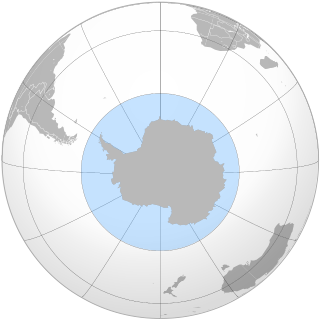
The Antarctic is a polar region around Earth's South Pole, opposite the Arctic region around the North Pole. The Antarctic comprises the continent of Antarctica, the Kerguelen Plateau and other island territories located on the Antarctic Plate or south of the Antarctic Convergence. The Antarctic region includes the ice shelves, waters, and all the island territories in the Southern Ocean situated south of the Antarctic Convergence, a zone approximately 32 to 48 km wide varying in latitude seasonally. The region covers some 20 percent of the Southern Hemisphere, of which 5.5 percent is the surface area of the Antarctic continent itself. All of the land and ice shelves south of 60°S latitude are administered under the Antarctic Treaty System. Biogeographically, the Antarctic realm is one of eight biogeographic realms of Earth's land surface.

The British Antarctic Territory (BAT) is a sector of Antarctica claimed by the United Kingdom as one of its 14 British Overseas Territories, of which it is by far the largest by area. It comprises the region south of 60°S latitude and between longitudes 20°W and 80°W, forming a wedge shape that extends to the South Pole, overlapping the Antarctic claims of Argentina and Chile.

The McMurdo Station is a United States Antarctic research station on the south tip of Ross Island, which is in the New Zealand–claimed Ross Dependency on the shore of McMurdo Sound in Antarctica. It is operated by the United States through the United States Antarctic Program, a branch of the National Science Foundation. The station is the largest community in Antarctica, capable of supporting up to 1,258 residents, and serves as one of three year-round United States Antarctic science facilities. All personnel and cargo going to or coming from Amundsen–Scott South Pole Station first pass through McMurdo. By road, McMurdo is 3 kilometres (1.9 mi) from New Zealand's smaller Scott Base.

The Australian Antarctic Territory (AAT) is a part of East Antarctica administered by the Australian Antarctic Division, an agency of the federal Department of the Environment and Energy. The territory's history dates to a claim on Enderby Land made by the United Kingdom in 1841, which was subsequently expanded and eventually transferred to Australia in 1933. It is the largest territory of Antarctica claimed by any nation by area. In 1961, the Antarctic Treaty came into force. Article 4 deals with territorial claims, and although it does not renounce or diminish any preexisting claims to sovereignty, it also does not prejudice the position of Contracting Parties in their recognition or non-recognition of territorial sovereignty. As a result, only four other countries—New Zealand, the United Kingdom, France, and Norway—recognise Australia's claim to sovereignty in Antarctica.

The Antarctic Peninsula, known as O'Higgins Land in Chile and Tierra de San Martin in Argentina, and originally as the Palmer Peninsula in the US and Graham Land in the United Kingdom, is the northernmost part of the mainland of Antarctica.
Antarctica has no official flag as the condominium that governs the continent has not yet formally selected one. Although the consultative members of the Antarctic Treaty System officially adopted an emblem in 2002 which is sometimes used as a flag, this emblem represents the Antarctic Treaty and not the continent itself. Antarctic Treaty members used the emblem for at least 30 years prior to its formal adoption, having used it on a 1971 commemorative stamp.

West Antarctica, or Lesser Antarctica, one of the two major regions of Antarctica, is the part of that continent that lies within the Western Hemisphere, and includes the Antarctic Peninsula. It is separated from East Antarctica by the Transantarctic Mountains and is covered by the West Antarctic Ice Sheet. It lies between the Ross Sea, and the Weddell Sea. It may be considered a giant peninsula, stretching from the South Pole towards the tip of South America.

A number of governments have set up permanent research stations in Antarctica and these bases are widely distributed. Unlike the drifting ice stations set up in the Arctic, the Research stations of the Antarctic are constructed either on rock or on ice that is fixed in place.

The taxonomic order Rhynchonellida is one of the two main groups of living articulate brachiopods, the other being the order Terebratulida. They are recognized by their strongly ribbed wedge-shaped or nut-like shells, and the very short hinge line.
The British Antarctic Survey (BAS) is the United Kingdom's national Antarctic operation. It is part of the Natural Environment Research Council. With over 400 staff, BAS takes an active role in Antarctic affairs, operating five research stations, two ships and five aircraft in both polar regions, as well as addressing key global and regional issues. This involves joint research projects with over 40 UK universities and more than 120 national and international collaborations.
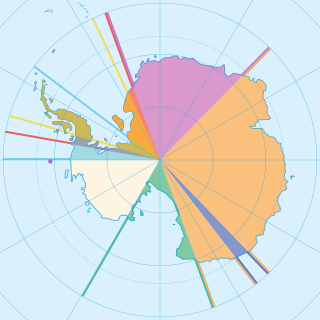
There are seven sovereign states who have made eight territorial claims in Antarctica: Argentina, Australia, Chile, France, New Zealand, Norway, and the United Kingdom. These countries have tended to place their Antarctic scientific observation and study facilities within their respective claimed territories; however, a number of such facilities are located outside of the area claimed by their respective countries of operation, and countries without claims such as India, Italy, Russia, Pakistan, Ukraine and the United States have constructed research facilities within the areas claimed by other countries.

Antarctica is Earth's southernmost continent. It contains the geographic South Pole and is situated in the Antarctic region of the Southern Hemisphere, almost entirely south of the Antarctic Circle, and is surrounded by the Southern Ocean. At 14,200,000 square kilometres, it is the fifth-largest continent and nearly twice the size of Australia. At 0.00008 people per square kilometre, it is by far the least densely populated continent. About 98% of Antarctica is covered by ice that averages 1.9 km in thickness, which extends to all but the northernmost reaches of the Antarctic Peninsula.

The Composite Gazetteer of Antarctica (CGA) of the Scientific Committee on Antarctic Research (SCAR) is the authoritative international gazetteer containing all Antarctic toponyms published in national gazetteers, plus basic information about those names and the relevant geographical features. The Gazetteer includes also parts of the International Hydrographic Organization (IHO) General Bathymetric Chart of the Oceans (GEBCO) gazetteer for under-sea features situated south of 60° south latitude.

The South Pole, also known as the Geographic South Pole or Terrestrial South Pole, is one of the two points where Earth's axis of rotation intersects its surface. It is the southernmost point on the surface of Earth and lies on the opposite side of Earth from the North Pole.
The Southern Ocean, also known as the Antarctic Ocean or the Austral Ocean, comprises the southernmost waters of the World Ocean, generally taken to be south of 60° S latitude and encircling Antarctica. As such, it is regarded as the second-smallest of the five principal oceanic divisions: smaller than the Pacific, Atlantic, and Indian oceans but larger than the Arctic Ocean. Over the past 30 years, the Southern Ocean has been subject to rapid climate change, which has led to changes in the marine ecosystem.
Many Antarctic research stations support satellite field camps which are, in general, seasonal camps. The type of field camp can vary – some are permanent structures used during the annual Antarctic summer, whereas others are little more than tents used to support short term activities. Field camps are used for many things, from logistics to dedicated scientific research.

The Antarctic Circle is the most southerly of the five major circles of latitude that mark maps of the Earth. The region south of this circle is known as the Antarctic, and the zone immediately to the north is called the Southern Temperate Zone. South of the Antarctic Circle, the sun is above the horizon for 24 continuous hours at least once per year and the centre of the sun is below the horizon for 24 continuous hours at least once per year ; this is also true within the equivalent polar circle in the Northern Hemisphere, the Arctic Circle.
| | This brachiopod-related article is a stub. You can help Wikipedia by expanding it. |