Adams, Jackson County, Wisconsin

Last updated

Adams, Wisconsin
WIMap-doton-Adams c.png
Location of Adams, Wisconsin
Coordinates: 44°21′39″N90°48′20″W / 44.36083°N 90.80556°W / 44.36083; -90.80556
Country Flag of the United States.svg  United States
State Flag of Wisconsin.svg  Wisconsin
County Jackson
Area
  Total37.0 sq mi (95.9 km2)
  Land36.0 sq mi (93.3 km2)
  Water1.0 sq mi (2.7 km2)
Elevation
[1]
899 ft (274 m)
Population
 (2000)
  Total1,208
  Density33.6/sq mi (13.0/km2)
Time zone UTC-6 (Central (CST))
  Summer (DST) UTC-5 (CDT)
FIPS code 55-00350 [2]
GNIS feature ID1582656 [1]

Adams is a town in Jackson County, Wisconsin, United States. The population was 1,208 at the 2000 census.

Contents

Adams was organized in 1938, from a part of Albion town. [3]

Geography

According to the United States Census Bureau, the town has a total area of 37.0 square miles (95.9 km2), of which 36.0 square miles (93.3 km2) of it is land and 1.0 square miles (2.7 km2) of it (2.81%) is water.

Demographics

As of the census [2] of 2000, there were 1,208 people, 485 households, and 353 families residing in the town. The population density was 33.6 people per square mile (13.0/km2). There were 564 housing units at an average density of 15.7 per square mile (6.0/km2). The racial makeup of the town was 94.54% White, 0.33% African American, 3.73% Native American, 0.25% Asian, 0.50% from other races, and 0.66% from two or more races. Hispanic or Latino of any race were 1.24% of the population.

There were 485 households, out of which 27.0% had children under the age of 18 living with them, 60.8% were married couples living together, 8.0% had a female householder with no husband present, and 27.2% were non-families. 20.6% of all households were made up of individuals, and 6.6% had someone living alone who was 65 years of age or older. The average household size was 2.47 and the average family size was 2.84.

In the town, the population was spread out, with 21.5% under the age of 18, 6.7% from 18 to 24, 27.2% from 25 to 44, 29.6% from 45 to 64, and 15.1% who were 65 years of age or older. The median age was 42 years. For every 100 females, there were 113.4 males. For every 100 females age 18 and over, there were 109.7 males.

The median income for a household in the town was $44,191, and the median income for a family was $50,288. Males had a median income of $30,481 versus $22,188 for females. The per capita income for the town was $19,729. About 2.7% of families and 4.8% of the population were below the poverty line, including 0.4% of those under age 18 and 13.4% of those age 65 or over.

Related Research Articles

<span class="mw-page-title-main">Sylvania, Alabama</span> Town in Alabama, United States

Sylvania is a town in DeKalb County, Alabama, United States. It incorporated in October 1967. At the 2010 census the population was 1,837, up from 1,186 in 2000. Sylvania is located atop Sand Mountain. Sylvania was incorporated in 1967. The post office /town hall was built in 1977.

<span class="mw-page-title-main">Malvern, Alabama</span> Town in Alabama, United States

Malvern is a town in Geneva County, Alabama, United States. It is part of the Dothan, Alabama Metropolitan Statistical Area. At the 2010 census the population was 1,448, up from 1,215 in 2000.

<span class="mw-page-title-main">Cottonwood, Alabama</span> Town in Alabama, United States

Cottonwood is a town in Houston County, Alabama, United States. One source said the town incorporated in 1901, although the 1910 U.S. Census stated 1903. It is part of the Dothan, Alabama Metropolitan Statistical Area. At the 2010 census the population was 1,289, up from 1,170 in 2000.

<span class="mw-page-title-main">Sidney, Illinois</span> Village in Illinois, United States

Sidney is a village in Champaign County, Illinois, United States. The population was 1,208 at the 2020 census.

<span class="mw-page-title-main">Portage Lake, Maine</span> Town in the state of Maine, United States

Portage Lake is a town in Aroostook County, Maine, United States. The population was 359 at the 2020 census.

<span class="mw-page-title-main">St. Francis, Maine</span> Town in the state of Maine, United States

St. Francis is a town in Aroostook County, Maine, United States on the Canada–United States border at the junction of the St. Francis River and the Saint John River. The population was 438 at the 2020 census. First settled by English speakers from southern Maine, the original population has been supplanted by French-speaking Acadians.

Cornville is a town in Somerset County, Maine, United States. The population was 1,317 at the 2020 census.

<span class="mw-page-title-main">Pigeon, Michigan</span> Village in Michigan, United States

Pigeon is a village in Huron County in the U.S. state of Michigan. The population was 1,208 at the 2010 census. The village is within Winsor Township.

<span class="mw-page-title-main">Country Club Hills, Missouri</span> City in Missouri, United States

Country Club Hills is a city in St. Louis County, Missouri, United States. The population was 1,274 at the 2010 census.

<span class="mw-page-title-main">Hampton, Nebraska</span> Village in Nebraska, United States

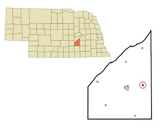
Hampton is a village in Hamilton County, in the state of Nebraska in the Midwestern United States. The population was 423 at the 2010 census.

<span class="mw-page-title-main">Orangeville, New York</span> Town in New York, United States

Orangeville is an incorporated town in Wyoming County, New York. The population was 1,301 at the 2000 census.

<span class="mw-page-title-main">Boiling Spring Lakes, North Carolina</span> City in North Carolina, United States

Boiling Spring Lakes is a city in Brunswick County, North Carolina, United States. The population was 5,943 at the 2020 census, up from 5,372 in 2010.

<span class="mw-page-title-main">Lanesboro, Pennsylvania</span> Borough in Pennsylvania, United States

Lanesboro is a borough in Susquehanna County, Pennsylvania, United States. The population was 485 at the 2020 census.

<span class="mw-page-title-main">Glencoe, Wisconsin</span> Town in Wisconsin, United States

Glencoe is a town in Buffalo County in the U.S. state of Wisconsin. The population was 485 at the 2010 census. The unincorporated community of Glencoe is located in the town.

<span class="mw-page-title-main">Burke, Wisconsin</span> Town in Wisconsin, United States

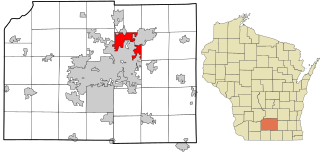
Burke is a town in Dane County, Wisconsin, United States. The population was 3,265 at the 2020 census. The unincorporated communities of Burke and Seminary Springs are in the town.

<span class="mw-page-title-main">Wilson, Eau Claire County, Wisconsin</span> Town in Wisconsin, United States

Wilson is a town in Eau Claire County, Wisconsin, United States. The population was 485 at the 2010 census. The unincorporated community of Wilson is located in the town.

<span class="mw-page-title-main">Nashville, Wisconsin</span> Town in Wisconsin, United States

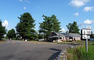
Nashville is a town in Forest County, Wisconsin, United States. The population was 1,064 at the 2010 census. The Mole Lake Indian Reservation is located within the town. The town is named after G.V. Nash of Forest City, Arkansas.

<span class="mw-page-title-main">Black Brook, Wisconsin</span> Town in Wisconsin, United States

Black Brook is a town in Polk County, Wisconsin, United States. The population was 1,208 at the 2000 census.

<span class="mw-page-title-main">New Auburn, Wisconsin</span> Village in Wisconsin, United States

New Auburn is a village in Barron and Chippewa counties in the U.S. state of Wisconsin. The population was 548 at the 2010 census. Of this, 528 were in Chippewa County, and 20 were in Barron County. The village is located mostly within the Town of Auburn in Chippewa County. Small portions extend east into the adjacent Town of Bloomer, Chippewa County and north into the Town of Dovre in Barron County.

Darien is a town in Walworth County, Wisconsin, United States. The population was 1,651 at the 2020 census. The Village of Darien is located within the town. The unincorporated community of Bardwell is located in the town. The unincorporated communities of Allen's Grove and Fairfield are also located partially in the town.

References

  1. 1 2 "US Board on Geographic Names". United States Geological Survey. October 25, 2007. Retrieved January 31, 2008.
  2. 1 2 "U.S. Census website". United States Census Bureau . Retrieved January 31, 2008.
  3. 1940 Census of Population (section for Wisconsin and Wyoming), pdf. p. 10