Taylor, Wisconsin

Last updated

Taylor, Wisconsin
Taylor, Wisconsin.jpg
Jackson County Wisconsin Incorporated and Unincorporated areas Taylor Highlighted.svg
Location of Taylor in Jackson County, Wisconsin.
Coordinates: 44°19′19″N91°7′17″W / 44.32194°N 91.12139°W / 44.32194; -91.12139
Country Flag of the United States.svg  United States
State Flag of Wisconsin.svg  Wisconsin
County Jackson
Area
[1]
  Total0.73 sq mi (1.89 km2)
  Land0.73 sq mi (1.89 km2)
  Water0.00 sq mi (0.00 km2)
Elevation
[2]
892 ft (272 m)
Population
 (2010) [3]
  Total476
  Estimate 
(2019) [4]
475
  Density651.58/sq mi (251.57/km2)
Time zone UTC-6 (Central (CST))
  Summer (DST) UTC-5 (CDT)
Area code(s) 715 & 534
FIPS code 55-79150 [5]
GNIS feature ID1575268 [2]
Website http://www.taylorwisconsin.us

Taylor is a village in Jackson County, Wisconsin, United States, along the Trempealeau River. The population was 484 at the 2020 census.

Contents

Geography

Taylor is located at 44°19′19″N91°7′17″W / 44.32194°N 91.12139°W / 44.32194; -91.12139 (44.322018, -91.121381). [6]

According to the United States Census Bureau, the village has a total area of 0.73 square miles (1.89 km2), all of it land. [7]

Demographics

Historical population
CensusPop.Note
1880 54
1920 313
1930 3398.3%
1940 314−7.4%
1950 35011.5%
1960 334−4.6%
1970 322−3.6%
1980 41127.6%
1990 4191.9%
2000 51322.4%
2010 476−7.2%
2019 (est.)475 [4] −0.2%
U.S. Decennial Census [8]

2010 census

As of the census [3] of 2010, there were 476 people, 212 households, and 120 families living in the village. The population density was 652.1 inhabitants per square mile (251.8/km2). There were 226 housing units at an average density of 309.6 per square mile (119.5/km2). The racial makeup of the village was 98.3% White, 0.6% African American, 0.6% Native American, 0.2% Asian, and 0.2% from two or more races. Hispanic or Latino of any race were 3.4% of the population.

There were 212 households, of which 30.2% had children under the age of 18 living with them, 36.8% were married couples living together, 12.7% had a female householder with no husband present, 7.1% had a male householder with no wife present, and 43.4% were non-families. 34.4% of all households were made up of individuals, and 14.2% had someone living alone who was 65 years of age or older. The average household size was 2.25 and the average family size was 2.83.

The median age in the village was 37.8 years. 23.1% of residents were under the age of 18; 10% were between the ages of 18 and 24; 26.1% were from 25 to 44; 26.5% were from 45 to 64; and 14.3% were 65 years of age or older. The gender makeup of the village was 48.9% male and 51.1% female.

2000 census

As of the census [5] of 2000, there were 513 people, 209 households, and 137 families living in the village. The population density was 706.6 people per square mile (271.3/km2). There were 237 housing units at an average density of 326.4 per square mile (125.4/km2). The racial makeup of the village was 97.27% White, 1.95% Native American, 0.58% Asian, and 0.19% from two or more races.

There were 209 households, out of which 33.5% had children under the age of 18 living with them, 45.5% were married couples living together, 13.9% had a female householder with no husband present, and 34.0% were non-families. 29.7% of all households were made up of individuals, and 13.9% had someone living alone who was 65 years of age or older. The average household size was 2.45 and the average family size was 2.91.

In the village, the population was spread out, with 29.8% under the age of 18, 9.0% from 18 to 24, 25.3% from 25 to 44, 21.8% from 45 to 64, and 14.0% who were 65 years of age or older. The median age was 36 years. For every 100 females, there were 101.2 males. For every 100 females age 18 and over, there were 98.9 males.

The median income for a household in the village was $25,833, and the median income for a family was $28,958. Males had a median income of $23,250 versus $17,961 for females. The per capita income for the village was $11,091. About 20.5% of families and 20.5% of the population were below the poverty line, including 18.7% of those under age 18 and 29.5% of those age 65 or over.

Notable person

Related Research Articles

New Vineyard is a town in Franklin County, Maine, United States. The population was 721 at the 2020 census.

<span class="mw-page-title-main">Elkton, Michigan</span> Village in Michigan, United States

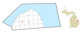
Elkton is a village in Huron County in the U.S. state of Michigan. The population was 796 at the 2020 census. The village is within Oliver Township, along the Pinnebog River. It was incorporated in 1897.

<span class="mw-page-title-main">Calumet, Minnesota</span> City in Minnesota, United States

Calumet is a city in Itasca County, Minnesota, United States. The population was 367 at the 2010 census.

<span class="mw-page-title-main">Chain of Rocks, Missouri</span> Village in Missouri, United States

Chain of Rocks is a village in Lincoln County, Missouri, United States. The population was 93 at the 2010 census.

<span class="mw-page-title-main">Glen Echo Park, Missouri</span> Former Village in Missouri, United States

Glen Echo Park was a village in St. Louis County, Missouri, United States. The population was 122 at the 2020 census. The community took its name from the nearby Glen Echo Country Club.

<span class="mw-page-title-main">Huntley, Nebraska</span> Village in Nebraska, United States

Huntley is a village in Harlan County, Nebraska, United States. The population was 44 at the 2010 census.

<span class="mw-page-title-main">Hayesville, Ohio</span> Village in Ohio, United States

Hayesville is a village in Vermillion Township, Ashland County, Ohio, United States. The population was 447 at the 2020 census.

<span class="mw-page-title-main">North Kingsville, Ohio</span> Village in Ohio, United States

North Kingsville is a village in Ashtabula County, Ohio, United States. The population was 2,742 at the 2020 census.

<span class="mw-page-title-main">Uniopolis, Ohio</span> Unincorporated community and Census-designated place in Ohio, United States

Uniopolis is an unincorporated community and former village in Auglaize County, Ohio, United States. The population was 188 at the 2020 census. It is included in the Wapakoneta, Ohio Micropolitan Statistical Area.

<span class="mw-page-title-main">Holloway, Ohio</span> Village in Ohio, United States

Holloway is a village in Belmont County, Ohio, United States. The population was 330 at the 2020 census. It is part of the Wheeling metropolitan area. Holloway was laid out in 1883, and named after the local Holloway family.

<span class="mw-page-title-main">Shawnee Hills, Delaware County, Ohio</span> Village in Ohio, United States

Shawnee Hills is a village in Delaware County, Ohio, United States. The population was 835 at the 2020 census. It is a part of the Columbus, Ohio Metropolitan Statistical Area.

<span class="mw-page-title-main">Cumberland, Ohio</span> Village in Guernsey County, Ohio, United States

Cumberland is a village in Guernsey County, Ohio, United States. It is seventy miles east of Columbus. The population was 317 at the 2020 census.

<span class="mw-page-title-main">Oak Grove Village, Missouri</span> Village in Missouri, United States

Oak Grove Village is a village in Franklin County, Missouri, United States. The population was 509 at the 2010 census.

<span class="mw-page-title-main">Pembroke, Virginia</span> Town in Virginia, United States

Pembroke is a town in Giles County, Virginia, United States. The population was 1,128 at the 2010 census. It is part of the Blacksburg–Christiansburg Metropolitan Statistical Area.

<span class="mw-page-title-main">Cameron, Barron County, Wisconsin</span> Village in Wisconsin, United States

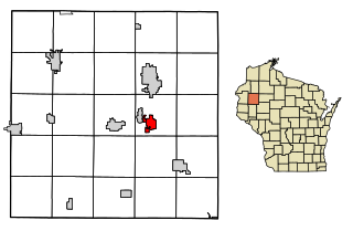
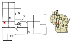
Cameron is a village in Barron County in the U.S. state of Wisconsin. The population was 1,783 at the 2010 census.

<span class="mw-page-title-main">Weyerhaeuser, Wisconsin</span> Village in Wisconsin, United States

Weyerhaeuser is a village in Rusk County, Wisconsin, United States. The population was 238 at the 2010 census.

<span class="mw-page-title-main">Wilson, St. Croix County, Wisconsin</span> Village in Wisconsin, United States

Wilson is a village in St. Croix County, Wisconsin, United States. The population was 184 at the 2010 census.

<span class="mw-page-title-main">Casco, Wisconsin</span> Village in Wisconsin, United States

Casco is a village in Kewaunee County, Wisconsin, United States. The population was 583 at the 2010 census. It is part of the Green Bay Metropolitan Statistical Area. The village is located within the Town of Casco. Casco is named after Casco Bay on the coast of Maine, the previous home of Edward Decker, an early logger in Kewaunee County.

Trempealeau is a town in Trempealeau County, Wisconsin, United States. The population was 1,618 at the 2000 census. The town surrounds the village of Trempealeau. The unincorporated communities of Centerville, West Prairie, and Wrights Corners are in the town.

<span class="mw-page-title-main">Lohrville, Wisconsin</span> Village in Wisconsin, United States

Lohrville is a village in Waushara County, Wisconsin, United States. The population was 402 at the 2010 census.

References

  1. "2019 U.S. Gazetteer Files". United States Census Bureau. Retrieved August 7, 2020.
  2. 1 2 "US Board on Geographic Names". United States Geological Survey. October 25, 2007. Retrieved January 31, 2008.
  3. 1 2 "U.S. Census website". United States Census Bureau . Retrieved November 18, 2012.
  4. 1 2 "Population and Housing Unit Estimates". United States Census Bureau. May 24, 2020. Retrieved May 27, 2020.
  5. 1 2 "U.S. Census website". United States Census Bureau . Retrieved January 31, 2008.
  6. "US Gazetteer files: 2010, 2000, and 1990". United States Census Bureau. February 12, 2011. Retrieved April 23, 2011.
  7. "US Gazetteer files 2010". United States Census Bureau. Archived from the original on January 25, 2012. Retrieved November 18, 2012.
  8. "Census of Population and Housing". Census.gov. Retrieved June 4, 2015.
  9. 'Wisconsin Blue Book 1915,' Biographical Sketch of B. L. Van Gorden, pg. 514