
Lahore District is a district in Punjab, Pakistan, consisting of the provincial capital, Lahore and surrounding areas. It is the most populous district of Pakistan, with a population of 12,978,661 in 2023.

Nakodar is a town and a municipal council in Jalandhar district in the Indian state of Punjab.

Jind district is one of the 22 districts of Haryana state in northern India. Jind town is the administrative headquarters of the district. It is part of Hisar Division and was created in 1966.

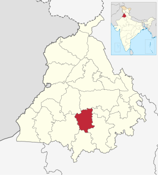
Mansa district is a district in the state of Punjab, India. The district headquarters is Mansa city. Mansa district was formed on 13 April 1992 from the erst while district of Bathinda. The district has three tehsils: Mansa, Budhlada and Sardulgarh; and five development blocks: Mansa, Budhlada, Sardulgarh, Bhikhi and Jhunir.

Jhang is the capital city of Jhang District in central Punjab, Pakistan. Situated on the east bank of the Chenab river, it is the 13th most populous city of Pakistan.

Ambala district is one of the 22 districts of Haryana state in the country of India with Ambala town serving as the administrative headquarters of the district. District Ambala lies on the North-Eastern edge of Haryana and borders Punjab and Himachal Pradesh. Ambala district is a part of Ambala Division.
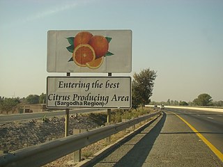
Sargodha District, is a district of Punjab, Pakistan. The capital of the district is Sargodha. It is an agricultural district with wheat, rice, sugarcane and kinnow being its main crops. The Sargodha district and region is also famous for citrus fruit including Kinnow, orange and lemon. The district has an area of 5,864 km2.

Jalandhar district is a district in Doaba region of the state of Punjab, India. The district headquarters is the city of Jalandhar.

Faridkot district is a district lying in the South-Western part of Punjab, India with Faridkot city as the district headquarters.

Rupnagar district is one of twenty-three districts in the state of Punjab, India. The city of Rupnagar is said to have been founded by a Raja called Rokeshar, who ruled during the 11th century and named it after his son Rup Sen. It is also the site of an ancient town of the Indus Valley civilization. The major cities in Rupnagar District are Morinda, Nangal and Anandpur Sahib. Morinda is also known as Baghwāla "[The City] of Gardens." Morinda is located on the Chandigarh-Ludhiana Highway. The Bhakra Dam in Nangal lies on the boundary with the neighboring state of Himachal Pradesh. Dadhi is one of the most important villages of the district, particularly because of Gurudwara Sri Hargobindsar Sahib.

Gujranwala District, is a district that is a part of the Majha region in Punjab, Pakistan. Gujranwala District is bordered by the districts of Wazirabad, Sialkot, Hafizabad and Sheikhupura. Gujranwala district has 5 National Assembly and 12 Punjab Assembly constituencies. Gujranwala is known as the city of wrestlers and famous for its food.

Mohali district, officially known as Sahibzada Ajit Singh Nagar district or SAS Nagar district, is one of the twenty three districts of Punjab, a state in north-west India. It was formed in April 2006 and is 18th district of Punjab, created next to Pathankot district. This district was carved out of areas falling in Ropar and Patiala District. It is situated next to the union territory of Chandigarh, Ambala and Panchkula districts of Haryana.
Hussainpur is a census town in Jalandhar district in the Indian state of Punjab. It is situated in Jalandhar II Tehsil. The village code is 030405.
Shahkot is a small city and one of the five tehsils of Jalandhar district in Punjab, India. Shahkot is situated on Jalandhar-Moga-Barnala-Sirsa National Highway 703. Shahkot is administered by the Municipal Committee. About 176 villages belong to Shahkot tehsil.
Tarn Taran district is one of the districts in the Majha region of Punjab, India. The main cities are Tarn Taran Sahib, Bhikhiwind, Khadur Sahib and Patti. The City of Tarn Taran Sahib is a holy place for Sikhs. Tarn Taran's Sikh population makes it the most heavily concentrated district of Sikhs in India and the world.

Fatehgarh Sahib district is one of the twenty-three districts of the state of Punjab, India, with its headquarters in the town of Fatehgarh Sahib.
Barnala is one of the districts of Indian state of Punjab. It was carved out of Sangrur district, in November 2006. It is a centrally located district bordered by Ludhiana district on the north, Moga district on northwest, Bathinda district on west, Sangrur district on east and Mansa district on south. As per census 2011, the population of District Barnala is 5,96,294. The town has a thriving industrial sector with two main industries: Trident Group and a large industry producing Combines.

Punjab is a state in northwestern India. Forming part of the larger Punjab region of the Indian subcontinent, the state is bordered by the Indian states of Himachal Pradesh to the north and northeast, Haryana to the south and southeast, and Rajasthan to the southwest; by the Indian union territories of Jammu and Kashmir to the north and Chandigarh to the east. It shares an international border with Punjab, a province of Pakistan to the west. The state covers an area of 50,362 square kilometres, which is 1.53% of India's total geographical area, making it the 19th-largest Indian state by area out of 28 Indian states. With over 27 million inhabitants, Punjab is the 16th-largest Indian state by population, comprising 23 districts. Punjabi, written in the Gurmukhi script, is the most widely spoken and the official language of the state. The main ethnic group are the Punjabis, with Sikhs (57.7%) and Hindus (38.5%) forming the dominant religious groups. The state capital, Chandigarh, is a union territory and also the capital of the neighbouring state of Haryana. Three tributaries of the Indus River — the Sutlej, Beas, and Ravi — flow through Punjab.

Fazilka district is one of 23 districts in the state of Punjab in India. The district headquarters of the Fazilka District are at Fazilka.

Pathankot district is the northernmost district of the Indian state of Punjab. Pathankot is the district headquarters. The district was formed on July 27, 2011. It borders Pakistan.

