
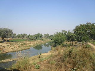
Bihar is a state in Eastern India. It is the third largest state by population, the 12th largest by area, and the 15th largest by GDP in 2021. Bihar borders Uttar Pradesh to its west, Nepal to the north, the northern part of West Bengal to the east, and Jharkhand to the south. Bihar is split by the river Ganges, which flows from west to east. On 15 November 2000, southern Bihar was ceded to form the new state of Jharkhand. Only 11.27% of the population of Bihar lives in urban areas as per a 2020 report. Additionally, almost 58% of Biharis are below the age of 25, giving Bihar the highest proportion of young people of any Indian state. The official language is Hindi, which shares official status alongside that of Urdu. The main native languages are Maithili, Magahi and Bhojpuri. But there are several other languages being spoken at smaller levels.

Vaishali district is a district in the Indian state of Bihar. It is a part of Tirhut division. Vaishali is known for being the birthplace of Mahavira of the Jain religion. Hajipur, its largest city and district headquarters, is known for its banana forest. The district is connected via the NH-77 and NH-322 highways, Gandhi Setu and Jay Prakash Setu Bridges over(Holy) Ganga River which connect the state capital Patna, the division headquarters Muzaffarpur, and the eastward district Samastipur.
Khagaria is a town in Indian state of Bihar and the administrative headquarters of Khagaria district. Khagaria is a part of Munger division. It is located at 25.5°N 86.48°E and has an average elevation of 36 metres. The Khagaria Junction railway station serves the town. It is situated about 25 km north of Munger.

Muzaffarpur is a city located in Muzaffarpur district in the Tirhut region of the Indian state of Bihar. It serves as the headquarters of the Tirhut division, the Muzaffarpur district and the Muzaffarpur Railway District.It is the fourth most populous city in Bihar.

Patna district is one of the thirty-eight districts of Bihar state in eastern India. Patna, the capital of Bihar, is the district headquarters. The Patna district is a part of Patna division. The Patna district is divided into 6 Sub-divisions (Tehsils) i.e. Patna Sadar, Patna City, Barh, Masaurhi, Danapur and Paliganj.

Madhubani district is one of the thirty-eight districts of Bihar, India, and is a part of Darbhanga division. Its administrative headquarters are located in Madhubani. The district has an area of 3,501 square kilometres (1,352 sq mi) and has a population of 4,487,379.

Arwal district is one of the thirty-eight districts of Bihar state, India, and Arwal town is the administrative headquarters of this district. It was earlier part of Jehanabad district.
Aurangabad district is one of the thirty-eight districts of Bihar state, India. It is currently a part of the Red Corridor. Aurangabad is also called "Chittorgarh" of Bihar because the number of Suryavanshi Rajputs is very high here. Aurangabad played a major role in the Indian independence struggle, and is also the birthplace of eminent nationalist & first Deputy Chief Minister of state, Bihar Vibhuti Dr. Anugrah Narayan Sinha, a participant of Champaran Satyagraha who is regarded among makers of modern independent Bihar.

Kaimur district is one of the 38 districts of Bihar, India. The district headquarters are at Bhabua. Before 1991, it was part of Rohtas District. Till 1764 the region was a part of Ghazipur District and was a part of Kamsaar Raj and later it was a part of Chainpur Estate till 1837.
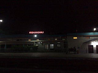
Kishanganj district is one of the thirty-eight districts of Bihar state, India, and Kishanganj town is the administrative headquarters of this district. Kishanganj district is a part of Purnia division (Seemanchal).
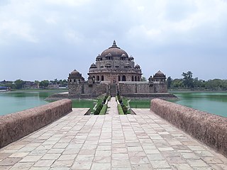
Rohtas District is one of the thirty-eight districts of Bihar state, India. It came into existence when Shahabad District was bifurcated into Bhojpur & Rohtas in 1972. Administrative headquarter of the district is Sasaram. Rohtas district has the highest literacy in Bihar. The literacy rate of Rohtas district which is 73.37% as per 2011 census is highest among all 38 districts of Bihar.

Dinhata is a city and a municipality in Cooch Behar district in the state of West Bengal, India. It is the headquarters of the Dinhata subdivision. Dinhata is known for arranging one of the best Durga Puja in North Bengal. Dinhata is famous for Sastho Mela and Dinhata Utsav, Sanghati Mela, Janmastami Mela. Apart from the city area, Dinhata consists of 3 blocks.
Haldibari is a city and a municipality in the Mekhliganj subdivision of the Cooch Behar district in the Indian state of West Bengal.

Literacy in India is a key for social-economic progress. The 2011 census, indicated a 2001–2011 literacy growth of 97.2%, which is slower than the growth seen during the previous decade. An old analytical 1990 study estimated that it would take until 2060 for India to achieve universal literacy at then-current rate of progress.

Piro is a nagar parishad town and corresponding community development block in Bhojpur District, in the Indian state of Bihar. Piro is 39 km from the Ara Railway Station. Jitaura is 6 km from Piro.

Maner also spelled Maner Sharif, is a Block and satellite town in Patna Metropolitan Region. It is part of the Patna district in the Indian state of Bihar. The ancient name of Maner was Maniyar Mathan which means musical city. Maner Sharif lies 24 km west of Patna, the capital of Bihar on NH-922. The town has tombs of Sufi saints Makhdoom Yahya Maneri and Makhdoom Shah Daulat, known as Bari Dargah and Chhoti Dargah.
Adalpur is a village in Hajipur block Vaishali district, Bihar, India.

Deo also known as Dev is a city council, town and a notified area in Deo, Block of Aurangabad district in the Indian state of Bihar. Deo is located 10 km to the southeast of District Administrative Aurangabad Bihar.

