Alarobia Bemaha is a town and commune in Madagascar. It belongs to the district of Betafo, which is a part of Vakinankaratra region. The population of the commune was estimated to be approximately 15,000 in 2001 commune census.[2]
Madagascar, officially the Republic of Madagascar, and previously known as the Malagasy Republic, is an island country in the Indian Ocean, approximately 400 kilometres off the coast of East Africa. The nation comprises the island of Madagascar and numerous smaller peripheral islands. Following the prehistoric breakup of the supercontinent Gondwana, Madagascar split from the Indian subcontinent around 88 million years ago, allowing native plants and animals to evolve in relative isolation. Consequently, Madagascar is a biodiversity hotspot; over 90% of its wildlife is found nowhere else on Earth. The island's diverse ecosystems and unique wildlife are threatened by the encroachment of the rapidly growing human population and other environmental threats.
Districts are second-level administrative divisions of Madagascar below the regions. There are 114 districts in Madagascar. Districts are in their turn divided into communes; while some of the districts in urban areas and offshore islands each consist of only one commune, most of the districts are divided typically into 5–20 communes.
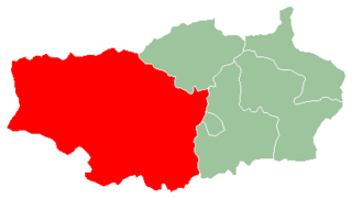
Betafo is a district in Vakinankaratra Region, Madagascar. The administrative centre of the district is the town of Betafo. In 2001, the district had an estimated 301,671 inhabitants, and was divided into 18 communes. However the district has subsequently been divided by the creation of the new Mandoto District from former parts of Betafo District. The reduced district covers an area of 4,155.03 sq.km, and it had an estimated population of 254,736 in mid 2013.
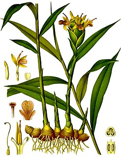
Only primary schooling is available. The majority 85% of the population of the commune are farmers, while an additional 15% receives their livelihood from raising livestock. The most important crops are maize and ginger, while other important agricultural products are beans and rice.[2]
Maize, also known as corn, is a cereal grain first domesticated by indigenous peoples in southern Mexico about 10,000 years ago. The leafy stalk of the plant produces pollen inflorescences and separate ovuliferous inflorescences called ears that yield kernels or seeds, which are fruits.
Ginger is a flowering plant whose rhizome, ginger root or ginger, is widely used as a spice and a folk medicine. It is a herbaceous perennial which grows annual pseudostems about a meter tall bearing narrow leaf blades. The inflorescences bear pale yellow with purple flowers and arise directly from the rhizome on separate shoots.
A bean is a seed of one of several genera of the flowering plant family Fabaceae, which are used for human or animal food.
A geographic coordinate system is a coordinate system that enables every location on Earth to be specified by a set of numbers, letters or symbols. The coordinates are often chosen such that one of the numbers represents a vertical position and two or three of the numbers represent a horizontal position; alternatively, a geographic position may be expressed in a combined three-dimensional Cartesian vector. A common choice of coordinates is latitude, longitude and elevation. To specify a location on a plane requires a map projection.
This page is based on this Wikipedia article Text is available under the CC BY-SA 4.0 license; additional terms may apply. Images, videos and audio are available under their respective licenses.
Related Research Articles
Ambarikorano or Ambariokorano is a town and commune in Madagascar. It belongs to the district of Mandritsara, which is a part of Sofia Region. The population of the commune was estimated to be approximately 9,000 in 2001 commune census.
Andranoboka is a town and commune in Madagascar. It belongs to the district of Mahajanga II, which is a part of Boeny Region. The population of the commune was estimated to be approximately 4,000 in the 2001 commune census.
Beratsimanana is a town and commune in Madagascar. It belongs to the district of Maevatanana, which is a part of Betsiboka Region. The population of the commune was estimated to be approximately 8,000 in 2001 commune census.
Ambohimahavelona is a town and commune in Madagascar. It belongs to the district of Toliara II, which is a part of Atsimo-Andrefana Region. The population of the commune was estimated to be 13,000 in a 2001 commune census.
Sabotsy Anjiro is a town and commune in Madagascar. It belongs to the district of Moramanga, which is a part of Alaotra-Mangoro Region. The population of the commune was estimated to be approximately 15,000 in 2001 commune census.
Belazao is a town and commune in Madagascar. It belongs to the district of Antsirabe II, which is a part of Vakinankaratra Region. The population of the commune was estimated to be approximately 11,000 in 2001 commune census. Belazao is located near the lake Tritriva.
Alakamisy Antivato is a town and commune in Madagascar. It belongs to the district of Betafo, which is a part of Vakinankaratra region. The population of the commune was estimated to be approximately 9,000 in 2001 commune census.
Ambatomanjaka is a town and commune in Madagascar. It belongs to the district of Miarinarivo, which is a part of Itasy Region. The population of the commune was estimated to be approximately 15,000 in 2001 commune census.
Ambohimandroso is a town and commune in Madagascar. It belongs to the district of Ambalavao, which is a part of Haute Matsiatra Region. The population of the commune was estimated to be approximately 12,000 in 2001 commune census.
Fanjakana is a town and commune in Madagascar. It belongs to the district of Fianarantsoa II, which is a part of Haute Matsiatra Region. The population of the commune was estimated to be approximately 10,000 in 2001 commune census.
Maneva is a town and commune in Madagascar. It belongs to the district of Fianarantsoa II, which is a part of Haute Matsiatra Region. The population of the commune was estimated to be approximately 6,000 in 2001 commune census.
Maroalomainty is a town and commune in Madagascar. It belongs to the district of Ambovombe, which is a part of Androy Region. The population of the commune was estimated to be approximately 18,000 in 2001 commune census.
Mahamaibe is a town and commune in Madagascar. It belongs to the district of Manakara, which is a part of Vatovavy-Fitovinany Region. The population of the commune was estimated to be approximately 9000 in 2001 commune census.
Ambodinonoka is a town and commune in Madagascar. It belongs to the district of Mananjary, which is a part of Vatovavy-Fitovinany Region. The population of the commune was estimated to be approximately 19,000 in 2001 commune census.
Ankarimbary is a town and commune in Madagascar. It belongs to the district of Vohipeno, which is a part of Vatovavy-Fitovinany Region. The population of the commune was estimated to be approximately 8,000 in 2001 commune census.
Fenoevo is a town and commune in Madagascar. It belongs to the district of Taolanaro, which is a part of Anosy Region. The population of the commune was estimated to be approximately 5,000 in 2001 commune census.
Mandiso is a town and commune in Madagascar. It belongs to the district of Taolanaro, which is a part of Anosy Region. The population of the commune was estimated to be approximately 6,000 in 2001 commune census.
Soanierana is a town and commune in Madagascar. It belongs to the district of Taolanaro, which is a part of Anosy Region. The population of the commune was estimated to be approximately 9,000 in 2001 commune census.
Fenoarivo is a town and commune in Madagascar. It belongs to the district of Ambatofinandrahana, which is a part of Amoron'i Mania Region. The population of the commune was estimated to be approximately 16,000 in 2001 commune census.
Mangataboahangy is a town and commune in Madagascar. It belongs to the district of Ambatofinandrahana, which is a part of Amoron'i Mania Region. The population of the commune was estimated to be approximately 8,000 in 2001 commune census.