Antanifotsy is an urban municipality and a district located in Vakinankaratra Region in Madagascar. It has a population of 54,448 in 2018. The city is at 112 km from Antananarivo and at 60 km to Antsirabe. The municipality is 3 km off the RN7 that passes at Ilempona Gara, at the entrance of Antanifotsy. This is also a railway station on the Antananarivo - Antsirabe line.

Vakinankaratra is a region in central Madagascar. The capital of the region is Antsirabe. Vakinankaratra covers an area of 16,599 kilometres, and had a population of 2,074,358 in 2018.

Fitovinany is a region located in southeast Madagascar. Its capital is Manakara. It is inhabited by the Antemoro people.

Amoron'i Mania is a region in central Madagascar bordering Vakinankaratra Region in north, Atsinanana in northeast, Fitovinany in southeast, Haute Matsiatra in south, Atsimo-Andrefana in southwest and Menabe in west.

Itasy is a region in central Madagascar. It borders Analamanga region in northeast, Vakinankaratra in south and Bongolava in northwest. The capital of the region is Miarinarivo, and the population was 897,962 in 2018. It is the smallest of all the 22 regions in area with 6,993 km2 (2,700 sq mi), and is the most densely populated region after Analamanga.

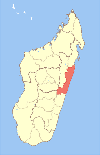
Atsinanana is a coastal region in eastern Madagascar. It borders Analanjirofo region in the north, Alaotra-Mangoro in the west, Vakinankaratra and Amoron'i Mania in the southwest, and Vatovavy in the south. The region contains over 285km of coastline, which includes many beaches and cultural heritage sites.
Ambatotsipihina is a rural commune in Madagascar. It belongs to the district of Antanifotsy, which is a part of Vakinankaratra Region. The population of the commune was 24,003 in 2018.
Ambatomiady is a rural municipality in Madagascar. It belongs to the district of Antanifotsy, which is a part of Vakinankaratra Region. The population of the commune was 31,140 in 2018.

Ambohimandroso is a town and commune in Madagascar. It belongs to the district of Antanifotsy, which is a part of Vakinankaratra Region. The population of the commune was estimated to be approximately 24,000 in 2001 commune census.
Ambohitompoina is a town and commune in Madagascar. It belongs to the district of Antanifotsy, which is a part of Vakinankaratra Region. The population of the commune was 27,899 in 2018.
Ampitatafika is a town and commune in Madagascar. It belongs to the district of Antanifotsy, which is a part of Vakinankaratra Region. The population of the commune was 32,955 in 2018.
Andranofito is a town and commune in Madagascar. It belongs to the district of Antanifotsy, which is a part of Vakinankaratra Region. The population of the commune was 15,127 in the 2018.
Antsahalava is a town and commune in Madagascar. It belongs to the district of Antanifotsy, which is a part of Vakinankaratra Region. The population of the commune was 29,556 in 2018.

Soanindrariny is a rural municipality in Madagascar. It belongs to the district of Antsirabe II, which is a part of Vakinankaratra Region. The population of the commune was estimated to be approximately 21,000 in the 2001 commune census.

Antsirabe II is a rural district in Vakinankaratra Region, Madagascar. The district surrounds the urban district and city of Antsirabe. It also borders the district of Faratsiho to the north, Antanifotsy to the east and Betafo to the west, in addition to the region of Antanifotsy to the south. The district covers a total area of 2,471.31 km2, with a population estimated at 406,353 in 2013.
Faratsiho is a town in Vakinankaratra Region, Madagascar. It is the capitol of the district of Faratsiho The district covers an area of 2,015 km2, with a total population estimated at 222,922 in 2018. The seat of the district administration is the town of Faratsiho.
Marolambo is a village and commune (kaominina) located in the Atsinanana region of eastern Madagascar. It is along the Nosivolo River near the junction with the Sandranamby River, and is also the capital of the Marolambo District.
The Marolambo National Park covers a forested region of Eastern Madagascar, between Marolambo, Antanifotsy, Fandriana, Nosy Varika (Vatovavy), Ifanadiana (Vatovavy) and Ambositra.
Soamanandrariny is a rural commune in Madagascar. It belongs to the district of Antanifotsy, which is a part of Vakinankaratra Region. The population of the commune was 24,003 in 2018.
Anjamanga is a rural commune in Madagascar. It belongs to the district of Antanifotsy, which is a part of Vakinankaratra Region. The population of the commune was 11,533 in 2018.


