Madagascar, officially the Republic of Madagascar, and previously known as the Malagasy Republic, is an island country in the Indian Ocean, approximately 400 kilometres off the coast of East Africa. At 592,800 square kilometres (228,900 sq mi) Madagascar is the world's 2nd largest island country. The nation comprises the island of Madagascar and numerous smaller peripheral islands. Following the prehistoric breakup of the supercontinent Gondwana, Madagascar split from the Indian subcontinent around 88 million years ago, allowing native plants and animals to evolve in relative isolation. Consequently, Madagascar is a biodiversity hotspot; over 90% of its wildlife is found nowhere else on Earth. The island's diverse ecosystems and unique wildlife are threatened by the encroachment of the rapidly growing human population and other environmental threats.
Districts are second-level administrative divisions of Madagascar below the regions. There are 114 districts in Madagascar. Districts are in their turn divided into communes; while some of the districts in urban areas and offshore islands each consist of only one commune, most of the districts are divided typically into 5–20 communes.
Ambatolampy is a district in Vakinankaratra Region, in Madagascar. The district is subdivided into 18 communes with a total population estimated at 256,164 in 2013.
Only primary schooling is available. The majority 98% of the population of the commune are farmers, while an additional 1% receives their livelihood from raising livestock. The most important crop is rice, while other important products are sweet potatoes and potatoes. Services provide employment for 1% of the population.[2]
Rice is the seed of the grass species Oryza sativa or Oryza glaberrima. As a cereal grain, it is the most widely consumed staple food for a large part of the world's human population, especially in Asia. It is the agricultural commodity with the third-highest worldwide production, after sugarcane and maize.
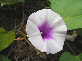
The sweet potato is a dicotyledonous plant that belongs to the bindweed or morning glory family, Convolvulaceae. Its large, starchy, sweet-tasting, tuberous roots are a root vegetable. The young leaves and shoots are sometimes eaten as greens. The sweet potato is only distantly related to the potato and does not belong to the nightshade family, Solanaceae, but both families belong to the same taxonomic order, the Solanales. The sweet potato, especially the orange variety, is often called a "yam" in parts of North America, but is botanically very distinct from true yams.
The potato is a root vegetable that is part of the plant Solanum tuberosum. This perennial is part of the family Solanaceae or the nightshades. In many contexts, the word potato refers to the edible starchy tuber portion of the plant, but it can also refer to the plant itself, which is native to the Americas.
A geographic coordinate system is a coordinate system that enables every location on Earth to be specified by a set of numbers, letters or symbols. The coordinates are often chosen such that one of the numbers represents a vertical position and two or three of the numbers represent a horizontal position; alternatively, a geographic position may be expressed in a combined three-dimensional Cartesian vector. A common choice of coordinates is latitude, longitude and elevation. To specify a location on a plane requires a map projection.
Ambodifarihy Fenomanana is a town and commune in Madagascar. It belongs to the district of Ambatolampy, which is a part of Vakinankaratra region. The population of the commune was estimated to be approximately 11,000 in 2001 commune census.
Ambohipihaonana is a town and commune in Madagascar. It belongs to the district of Ambatolampy, which is a part of Vakinankaratra region. The population of the commune was estimated to be approximately 17,000 in 2001 commune census.
Andravola Vohipeno is a town and commune in Madagascar. It belongs to the district of Ambatolampy, which is a part of Vakinankaratra region. The population of the commune was estimated to be approximately 5,000 in 2001 commune census.
Antanamalaza is a town and commune in Madagascar. It belongs to the district of Ambatolampy, which is a part of Vakinankaratra Region. The population of the commune was estimated to be approximately 12,000 in 2001 commune census.
Belambo is a town and commune in Madagascar. It belongs to the district of Ambatolampy, which is a part of Vakinankaratra Region. The population of the commune was estimated to be approximately 14,000 in 2001 commune census.
Sabotsy Namatoana is a town and commune in Madagascar. It belongs to the district of Ambatolampy, which is a part of Vakinankaratra Region. The population of the commune was estimated to be approximately 8,000 in 2001 commune census.
Ambohimandroso is a town and commune in Madagascar. It belongs to the district of Antanifotsy, which is a part of Vakinankaratra Region. The population of the commune was estimated to be approximately 24,000 in 2001 commune census.
Ambohitompoina is a town and commune in Madagascar. It belongs to the district of Antanifotsyu, which is a part of Vakinankaratra Region. The population of the commune was estimated to be approximately 41,000 in 2001 commune census.
Ampitatafika is a town and commune in Madagascar. It belongs to the district of Antanifotsy, which is a part of Vakinankaratra Region. The population of the commune was estimated to be approximately 32,000 in 2001 commune census.
Antsampandrano is a town and commune in Madagascar. It belongs to the district of Antanifotsy, which is a part of Vakinankaratra Region. The population of the commune was estimated to be approximately 19,000 in 2001 commune census.
Andranomanelatra is a town and commune in Madagascar. It belongs to the district of Antsirabe II, which is a part of Vakinankaratra Region. The population of the commune was estimated to be approximately 30,000 in 2001 commune census.
Ambohiborona is a town and commune in Madagascar. It belongs to the district of Faratsiho, which is a part of Vakinankaratra Region. The population of the commune was estimated to be approximately 26,000 in 2001 commune census.
Vinaninony Nord is a town and commune in Madagascar. It belongs to the district of Faratsiho, which is a part of Vakinankaratra Region. The population of the commune was estimated to be approximately 8,000 in 2001 commune census.
Marofangady is a town and commune in Madagascar. It belongs to the district of Arivonimamo, which is a part of Itasy Region. The population of the commune was estimated to be approximately 3,000 in 2001 commune census.
Fandrandava is a town and commune in Madagascar. It belongs to the district of Fianarantsoa II, which is a part of Haute Matsiatra Region. The population of the commune was estimated to be approximately 9,000 in 2001 commune census.
Alakamisy Ambohimahazo is a town and commune in Madagascar. It belongs to the district of Fandriana, which is a part of Amoron'i Mania Region. The population of the commune was estimated to be approximately 9,000 in 2001 commune census.
Ankarinoro is a town and commune in Madagascar. It belongs to the district of Fandriana, which is a part of Amoron'i Mania Region. The population of the commune was estimated to be approximately 7,000 in 2001 commune census.
Milamaina is a town and commune in Madagascar. It belongs to the district of Fandriana, which is a part of Amoron'i Mania Region. The population of the commune was estimated to be approximately 7,000 in 2001 commune census.
Sahamadio is a town and commune in Madagascar. It belongs to the district of Fandriana, which is a part of Amoron'i Mania Region. The population of the commune was estimated to be approximately 17,000 in 2001 commune census.
Mantasoa is a town and commune in Madagascar. It belongs to the district of Manjakandriana, which is a part of Analamanga Region. The population of the commune was estimated to be approximately 10,000 in 2001 commune census.
This page is based on this Wikipedia article Text is available under the CC BY-SA 4.0 license; additional terms may apply. Images, videos and audio are available under their respective licenses.