Soanindrariny

Last updated
Soanindrariny
Soanindrariny vu du Sud.jpg
Soanindrariny
Madagascar location map.svg
Red pog.svg
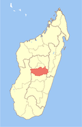
Soanindrariny
Location in Madagascar
Coordinates: 19°54′S47°14′E / 19.900°S 47.233°E / -19.900; 47.233
CountryFlag of Madagascar.svg  Madagascar
Region Vakinankaratra
District Antsirabe II
Elevation
[1]
1,788 m (5,866 ft)
Population
 (2001) [2]
  Total21,000
  Ethnicities
Merina
Time zone UTC3 (EAT)

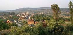
Soanindrariny is a rural municipality in Madagascar. It belongs to the district of Antsirabe II, which is a part of Vakinankaratra Region. The population of the commune was estimated to be approximately 21,000 in the 2001 commune census. [2]

Primary and junior level secondary education are available in town. The majority 95% of the population of the commune are farmers, while an additional 5% receives their livelihood from raising livestock. The most important crops are rice and fruits, while other important agricultural products are maize and potatoes. [2]

Roads

Soanindrariny is situated at 22 km east of Antsirabe with which it is connected by an unpaved Provincial road 122, and to the north to Antanifotsy by the Provincial road 111. [3]

Related Research Articles

<span class="mw-page-title-main">Vakinankaratra</span> Region in Madagascar

Vakinankaratra is a region in central Madagascar. The capital of the region is Antsirabe. Vakinankaratra covers an area of 16,599 kilometres, and had a population of 2,074,358 in 2018.

<span class="mw-page-title-main">Behenjy</span> Place in Vakinankaratra, Madagascar

Behenjy is a rural municipality in Madagascar. It belongs to the district of Ambatolampy, which is a part of Vakinankaratra Region. The population of the commune was estimated to be approximately 18,000 in 2001 commune census.

<span class="mw-page-title-main">Ambohimandroso, Antanifotsy</span> Place in Vakinankaratra, Madagascar

Ambohimandroso is a town and commune in Madagascar. It belongs to the district of Antanifotsy, which is a part of Vakinankaratra Region. The population of the commune was estimated to be approximately 24,000 in 2001 commune census.

Tsarahonenana Sahanivotry is a town and commune in Madagascar. It belongs to the district of Antsirabe II, which is a part of Vakinankaratra Region. The population of the commune was estimated to be approximately 14,000 in 2001 commune census.

Alakamisy is a town and commune in Madagascar. It belongs to the district of Antsirabe II, which is a part of Vakinankaratra region. The population of the commune was estimated to be approximately 18,000 in 2001 commune census.

Ambano is a town and commune in Madagascar. It belongs to the district of Antsirabe II, which is a part of Vakinankaratra Region. The population of the commune was estimated to be approximately 32,000 in the 2001 commune census.

Ambatomena is a town and commune in Madagascar. It belongs to the district of Antsirabe II, which is a part of Vakinankaratra Region. The population of the commune was estimated to be approximately 19,000 in 2001 commune census.

Ambohibary is a municipality in Madagascar. It belongs to the district of Antsirabe II, which is a part of Vakinankaratra Region. The population of the commune was estimated to be approximately 52,000 in 2001 commune census.

Ambohidranandriana is a town and commune in Madagascar. It belongs to the district of Antsirabe II, which is a part of Vakinankaratra Region. The population of the commune was estimated to be approximately 11,000 in 2001 commune census.

Ambohitsimanova is a town and commune in Madagascar. It belongs to the district of Antsirabe II, which is a part of Vakinankaratra Region. The population of the commune was estimated to be approximately 17,000 in 2001 commune census.

Andranomanelatra is a town and commune in Madagascar. It belongs to the district of Antsirabe II, which is a part of Vakinankaratra Region. The population of the commune was estimated to be approximately 30,000 in 2001 commune census.

Antanambao is a town and commune in Madagascar. It belongs to the district of Antsirabe II, which is a part of Vakinankaratra Region. The population of the commune was estimated to be approximately 21,000 in 2001 commune census.

Antsoatany is a town and commune in Madagascar. It belongs to the district of Antsirabe II, which is a part of Vakinankaratra Region. The population of the commune was estimated to be approximately 10,000 in 2001 commune census.

Ibity is a town and commune in Madagascar. It belongs to the district of Antsirabe II, which is a part of Vakinankaratra Region. The population of the commune was estimated to be approximately 11,000 in 2001 commune census.

Mandrosohasina is a municipality in Madagascar. It belongs to the district of Antsirabe II, which is a part of Vakinankaratra Region. The population of the commune was estimated to be approximately 20,000 in 2001 commune census.

Sahanivotry Mandona is a town and commune in Madagascar. It belongs to the district of Antsirabe II, which is a part of Vakinankaratra Region. The population of the commune was estimated to be approximately 10,000 in 2001 commune census.

Vinaninkarena is a town and commune in Madagascar. It belongs to the district of Antsirabe II, which is a part of Vakinankaratra Region. The population of the commune was estimated to be approximately 11,000 in 2001 commune census.

Ambohimiarivo is a town and commune in Madagascar. It belongs to the district of Antsirabe II, which is a part of Vakinankaratra Region. The population of the commune was estimated to be approximately 10,000 in 2001 commune census.

Alakamisy Anativato is a rural municipality in Madagascar. It belongs to the district of Betafo, which is a part of Vakinankaratra region. It is situated in a distance of 127 km South-West of Antananarivo and 21 km West of Antsirabe. The population of the commune was 10754 in 2018.

Ankazomiriotra is a rural municipality in Madagascar. It belongs to the district of Mandoto, which is a part of Vakinankaratra Region. The population of the commune was estimated to be approximately 34,000 in 2001 commune census.

References

  1. Estimated based on DEM data from Shuttle Radar Topography Mission
  2. 1 2 3 "ILO census data". Cornell University. 2002. Retrieved 2008-04-22.
  3. Roads in Vakinaratra

19°54′S47°14′E / 19.900°S 47.233°E / -19.900; 47.233