Vakinankaratra

Last updated
Vakinankaratra Region
Region
Antsirabe - rue principale01.JPG
Madagascar-Vakinankaratra Region.png
Location in Madagascar
CountryFlag of Madagascar.svg  Madagascar
Capital Antsirabe
Government
[1]
  Governor Vy Vato Rakotovao
Area
  Total16,599 km2 (6,409 sq mi)
Population
 (2018) [2]
  Total2,074,358
  Density120/km2 (320/sq mi)
  Ethnicities
Merina
Time zone UTC3 (EAT)
HDI (2018)0.531 [3]
low · 8th of 22

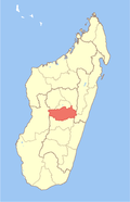
Vakinankaratra is a region in central Madagascar. The capital of the region is Antsirabe. Vakinankaratra covers an area of 16,599 kilometres (10,314 miles), and had a population of 2,074,358 in 2018. [2]

Contents

History

The kingdom of Vakinankaratra, known as the kingdom of the river Andrantsay, was founded at the beginning of the 17th century by Andrianony, a prince originally from Alasora, south of Antananarivo. The capital of the kingdom used to be Fivavahana in today's Betafo District.

The last ruler of the Kingdom of Andrantsay was Andriamanalinarivo who was on the throne when Imerina king Andrianampoinimerina conquered the area with the help of the young prince Radama at the beginning of the 19th century. The territory was integrated into the Merina Kingdom under the new name Vakinankaratra.

During the colonial period the centre of the region shifted to Antsirabe.

Population

Vakinankaratra is the second most populous region of Madagascar and it has the second highest population density, only beaten by Analamanga, where the national capital and biggest city, Antananarivo, is located. In 2018, Vakinankaratra had a population of 2,074,358 and an average density of 117.0 people per km². [2] The vast majority of the population belongs to the Merina ethnic group.

Economy

Vakinankaratra generates 10% of the GDP of Madagascar. There is an important textile industry and it is the principal bassin of legume production of the island. It also supplies 65% of the milk produced in Madagascar. [4]

Geography

A polished slice of liddicoatite from Betafo Liddicoatite-68003.jpg
A polished slice of liddicoatite from Betafo

Vakinankaratra is situated in the central highlands of Madagascar. The region covers an area of 16,599 km2 (6,409 sq mi), making it the third least extensive region in Madagascar. It borders the region of Bongolava in the northwest, Itasy in the north, Analamanga in the northeast, Alaotra Mangoro and Atsinanana in the east, Amoron'i Mania in the south, and Menabe to the west.

A number of precious minerals are found in Vakinankaratra, including Ferrocolumbite, Liddicoatite, and Londonite.

Bodies of Water

Protected Area

Administrative divisions

Vakinankaratra Region is divided into seven districts, which are sub-divided into 89 communes.

Transport

Airport

Roads

Railways

Sports

Football:

Basketball:


See also

Related Research Articles

<span class="mw-page-title-main">Antananarivo Province</span> Province in Madagascar

Antananarivo Province is a former province of Madagascar with an area of 58,283 square kilometres (22,503 sq mi). It had a population of 5,370,900 in 2004. Its capital was Antananarivo, which is also the capital of the country. Established in 1965, it was the most important province of Madagascar in terms of industrial production. It was one of the most literate provinces and was dominated by the Merina people. Along with the other five provinces, it was abolished in 2007 after a referendum in favour of creation of smaller regions to help in development was approved. It was badly affected by plagues in the 20th century. In 2002 a state of emergency was proclaimed by the then president Didier Ratsiraka. The events that followed led to the other five provinces announcing the creation of a new republic that would have excluded Antananarivo Province. Peace was restored only when Marc Ravalomanana was installed as the country's president.

<span class="mw-page-title-main">Antsirabe</span> Place in Vakinankaratra, Madagascar

Antsirabe is the third largest city in Madagascar and the capital of the Vakinankaratra region, with a population of 265,018 in 2014. In Madagascar, Antsirabe is known for its relatively cool climate, its industry and the high concentration of pulled rickshaws or pousse-pousse. It attracts around 30,000 tourists a year.

<span class="mw-page-title-main">Antanifotsy</span> Place in Vakinankaratra, Madagascar

Antanifotsy is an urban municipality and a district located in Vakinankaratra Region in Madagascar. It has a population of 54,448 in 2018. The city is at 112 km from Antananarivo and at 60 km to Antsirabe. The municipality is 3 km off the RN7 that passes at Ilempona Gara, at the entrance of Antanifotsy. This is also a railway station on the Antananarivo - Antsirabe line.

<span class="mw-page-title-main">Ankaratra</span>

Ankaratra is a cinder cone volcano range located about 50 km (30 mi) southwest of Antananarivo, the capital city of Madagascar. It lies between the towns of Arivonimamo to the north, Ambatolampy to the east, Faratsiho to the west and Betafo to the south. It is located in the Central Highlands. The highest peak in Ankaratra is Mount Tsiafajavona, at 2,644 metres (8,668 ft.) above sea level. Some trace of activity remains in the southernmost part of the range, creating hot springs in the area around Antsirabe. The last eruption of Ankaratra took place in the very recent Quaternary.

<span class="mw-page-title-main">Analamanga</span> Region in Madagascar

Analamanga is a region in central Madagascar, containing the capital Antananarivo and its surrounding metropolitan area. The region has an area of 17,488 square kilometres, and had a population of 4,325.226 in 2018.

<span class="mw-page-title-main">Bongolava</span> Region in Madagascar

Bongolava is a region in central-western Madagascar. The capital of the region is Tsiroanomandidy. It had a population of 674,474 in 2018.

<span class="mw-page-title-main">Ambatolampy</span> Place in Vakinankaratra, Madagascar

Ambatolampy is a city in the Vakinankaratra Region, situated in the Central Highlands of Madagascar. It had a population of about 28,500 in 2013.

<span class="mw-page-title-main">Betafo</span> Place in Vakinankaratra, Madagascar

Betafo is a town and urban municipality in Vakinankaratra Region in the Central Highlands of Madagascar. It is surrounded by volcanic peaks and is situated 22 km from Antsirabe. It is a typical Merina town in the Central Highlands.

<span class="mw-page-title-main">Menabe</span> Region in Madagascar

Menabe is a region in western Madagascar, with its capital at Morondava. It covers an area of 46,121 square kilometres, and its population was 700,577 in 2018. The population mostly belongs to the Sakalava ethnic group. The region is named after the 18th-century Sakalava Kingdom of Menabe. The name "Menabe", in turn, means "big red", after the color of laterite rock that dominates the landscape.

<span class="mw-page-title-main">Itasy Region</span> Region in Madagascar

Itasy is a region in central Madagascar. It borders Analamanga region in northeast, Vakinankaratra in south and Bongolava in northwest. The capital of the region is Miarinarivo, and the population was 897,962 in 2018. It is the smallest of all the 22 regions in area with 6,993 km2 (2,700 sq mi), and is the most densely populated region after Analamanga.

<span class="mw-page-title-main">Districts of Madagascar</span> Administrative division of Madagascar

Districts are second-level administrative divisions of Madagascar below the regions. There are 114 districts in Madagascar. Districts are in their turn divided into communes; while some of the districts in urban areas and offshore islands each consist of only one commune, most of the districts are divided typically into 5–20 communes.

<span class="mw-page-title-main">Behenjy</span> Place in Vakinankaratra, Madagascar

Behenjy is a rural municipality in Madagascar. It belongs to the district of Ambatolampy, which is a part of Vakinankaratra Region. The population of the commune was estimated to be approximately 18,000 in 2001 commune census.

Tsiafajavona Ankaratra is a rural municipality in Madagascar. It belongs to the district of Ambatolampy, which is a part of Vakinankaratra Region. The population of the commune was estimated to be approximately 15,000 in 2001 commune census. It is situated at 12 km from Ambatolampy and 79 km from the capital Antananarivo.

Alakamisy Anativato is a rural municipality in Madagascar. It belongs to the district of Betafo, which is a part of Vakinankaratra region. It is situated in a distance of 127 km South-West of Antananarivo and 21 km West of Antsirabe. The population of the commune was 10754 in 2018.

<span class="mw-page-title-main">Betafo District</span> District in Vakinankaratra, Madagascar

Betafo is a district in Vakinankaratra Region, Madagascar. The administrative centre of the district is the town of Betafo. However the district has subsequently been divided by the creation of the new Mandoto District from former parts of Betafo District. The reduced district covers an area of 4,607 km, and it had an estimated population of 331,696 in 2018. It is situated at 22 km west of Antsirabe.

<span class="mw-page-title-main">Antsirabe I District</span> District in Vakinankaratra, Madagascar

Antsirabe I is a district in, and capital of, Vakinankaratra Region, Madagascar. The borders of the district are identical to those of the city and urban commune of Antsirabe.

<span class="mw-page-title-main">Antsirabe II District</span> District in Vakinankaratra, Madagascar

Antsirabe II is a rural district in Vakinankaratra Region, Madagascar. The district surrounds the urban district and city of Antsirabe. It also borders the district of Faratsiho to the north, Antanifotsy to the east and Betafo to the west, in addition to the region of Antanifotsy to the south. The district covers a total area of 2,471.31 km2, with a population estimated at 475,556 in 2020.

<span class="mw-page-title-main">Ambatolampy District</span> District in Vakinankaratra, Madagascar

Ambatolampy is a district in Vakinankaratra Region, in Madagascar. The district has a total population estimated at 299,512 in 2018. The seat of the district administration is the town of Ambatolampy. It is situated at 70 km South from the capital Antananarivo from where it can be reached by the National road 7.

Faratsiho is a town in Vakinankaratra Region, Madagascar. It is the capitol of the district of Faratsiho The district covers an area of 2,015 km2, with a total population estimated at 222,922 in 2018. The seat of the district administration is the town of Faratsiho.

<span class="mw-page-title-main">Route nationale 7 (Madagascar)</span>

Route nationale 7 (RN7) is a primary highway in Madagascar running 980km from the capital Antananarivo to Tulear at the south-west coast of the country. It crosses the regions of Analamanga, Vakinankaratra, Amoron'i Mania, Haute Matsiatra, Ihorombe, and Atsimo-Andrefana.

References

  1. EDBM
  2. 1 2 3 "Troisieme Recensement General de la Population et de L'Habitation (RGPH-3) Resultats Provisoires" (PDF). Institut National de la Statistique Madagascar. Retrieved May 23, 2020.
  3. "Sub-national HDI - Area Database - Global Data Lab". hdi.globaldatalab.org. Retrieved 2018-09-13.
  4. [(in French): https://lexpress.mg/08/09/2020/filiere-lait-loffre-loin-de-la-demande/ lexpress.mg Filiere Lait]
  5. Dr.RANAIVOSOA Voajanahary, Caractérisation sédimentologique et l érosion hydrique à AntsahalavaAmbatomitsangana-Commune de Behenjy
  6. allafrica.com
  7. L'Express de Madagascar: Ligne Antananarivo-Antsirabe

19°52′05″S47°02′02″E / 19.868°S 47.034°E / -19.868; 47.034