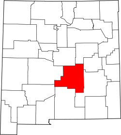
Alto, New Mexico | |
---|---|
Coordinates: 33°23′55″N105°40′51″W / 33.39861°N 105.68083°W | |
Country | United States |
State | New Mexico |
County | Lincoln |
Time zone | UTC-7 (Mountain (MST)) |
• Summer (DST) | UTC-6 (MDT) |
ZIP code | 88312 [1] |
Area code | 575 |
GNIS feature ID | 903117 [2] |
Alto is an unincorporated community in Lincoln County, New Mexico, United States. [2]
In June 2024, due to the rapid spread of the South Fork Fire and Salt Fire, all residents of Alto were ordered to evacuate until the fire could be contained. [3]
Alto is located at an elevation of 7,550 feet (2,300 m) in the Lincoln National Forest, five miles (8.0 km) north of the village of Ruidoso. Alto received its name from the Spanish word "high" because of its elevation.
Alto Lakes is a planned, residential and recreational community covering 1689+ acres along two mountain ridges in Alto. Alto Lakes was conceived and developed by Don Blaugrund beginning in 1967. The heart of the community is the Alto Lakes Golf & Country Club which includes two private 18-hole golf courses, dining, swimming and tennis facilities. Membership in the club is included with ownership of a home, town home, or lot within the community. The residential area of the community includes 1,150+ homes, 83 town homes, and approximately 1,000 vacant lots. Alto Lakes is governed by the Alto Lakes Water & Sanitation District and by the Alto Lakes Special Zoning District as well as community covenants.
Lincoln County is a county in the U.S. state of New Mexico. As of the 2020 census, the population was 20,269. Its county seat is Carrizozo, while its largest community is Ruidoso.
Arizona City is an unincorporated census-designated place (CDP) in southwestern Pinal County, Arizona, United States. It is located near the junction of Interstate 8 and Interstate 10 at the midpoint between Phoenix and Tucson, approximately 60 miles (97 km) from the downtown of both cities. The population was 10,475 as of the 2010 U.S. Census. It is estimated to be approximately 11,030 as of a 2017 U.S. Census estimate. Arizona City is a rural, primarily residential community that features a 48-acre man-made lake These attributes make the community a popular snowbird destination, with the population increasing by as much as 5,000 people in the winter months to reach the census figure of 11,030. Most recently after the last Census, many full-time residents have relocated to the unincorporate town.
Lake in the Hills is a village in McHenry County, Illinois, United States. As of the 2020 census, the population was 28,982.
Ruidoso is a village in Lincoln County, New Mexico, United States, adjacent to the Lincoln National Forest. The population was 7,679 at the 2020 census. The city of Ruidoso Downs and the unincorporated area of Alto are suburbs of Ruidoso, and contribute to the Ruidoso Micropolitan Statistical Area's population of 21,223.
Carmel is a town in Putnam County, New York, United States. As of the 2020 United States census, the town had a population of 33,576.
Cramerton is a small town in Gaston County, North Carolina, United States. It is a suburb of Charlotte and located east of Gastonia. The population was 4,165 at the 2010 census. A well-known feature is the Cramer Mountain gated development, featuring homes around an 18-hole golf course at Cramer Mountain Country Club.
The Angeles National Forest (ANF) of the United States Forest Service is located in the San Gabriel Mountains and Sierra Pelona Mountains, primarily within Los Angeles County in southern California. The ANF manages a majority of the San Gabriel Mountains National Monument.
The Greater Grand Forks Greenway is a huge greenway bordering the Red River and Red Lake River in the twin cities of Grand Forks, North Dakota and East Grand Forks, Minnesota. At 2,200 acres (9 km2), the Greenway is more than twice the size of New York City's Central Park. It has an extensive, 20-mile (32 km) system of bike paths, which are used by bikers, walkers, joggers, and rollerbladers. In 2007, the system was designated as a National Recreation Trail by the National Park Service.
Lincoln is an unincorporated village in Lincoln County, New Mexico, United States.
Bonito Lake is an alpine reservoir located high in the Sierra Blanca mountains northwest of Ruidoso, New Mexico. It is a popular fishing and camping destination, and although it is surrounded by the Lincoln National Forest, it is not a part of the national forest. It is currently owned by the city of Alamogordo, New Mexico as their primary water source. Because of the high altitude, the lake's temperature is cold year round, and is home to an abundance of rainbow trout. The area around the lake has several campgrounds with hiking trails and streams. The 2012 Little Bear Fire caused severe erosion in the watershed above the lake, flooding and the lake was contaminated with sediment and ash. In 2015 the lake was drained in order to dredge it.
Arastradero Preserve, officially known as Enid W. Pearson–Arastradero Preserve, is a 622 acres nature preserve that protects most of the Arastradero Creek watershed, including its ephemeral Mayfly Creek tributary. It also includes the upper reach of the Felt Creek tributary to Stanford's Felt Reservoir. The preserve is owned and operated by the City of Palo Alto, California. The main parking lot hosts an interpretive center and is located at 1530 Arastradero Road.
Lincoln National Forest is a unit of the U.S. Forest Service located in southern New Mexico. The Lincoln National Forest covers an extensive 1.1 million acres in southeastern New Mexico. Established by Presidential Proclamation in 1902 as the Lincoln Forest Reserve, the 1,103,897 acres (4,467.31 km2) forest begins near the Texas border and contains lands in parts of Chaves, Eddy, Lincoln, and Otero counties. The Lincoln National Forest is home to three major mountain ranges: Sacramento, Guadalupe and Capitan. The three Ranger Districts within the forest contain all or part of a total of four mountain ranges, and include a variety of different environmental areas, from desert to heavily forested mountains and sub-alpine grasslands. Clean air, water, and soil are necessary elements that the National Forests contribute to the environment. Established to balance conservation, resource management, and recreation, the lands of the Lincoln National Forest include important local timber resources, protected wilderness areas, and popular recreation and winter sports areas. The forest headquarters is located in Alamogordo, N.M. with local offices in Carlsbad, Cloudcroft, and Ruidoso.
The Rio Ruidoso is a 30-mile (48 km) long river located in the Sierra Blanca and Sacramento Mountains in Lincoln County and Otero County, New Mexico in the United States and is part of the Rio Ruidoso Watershed. The Spanish term, río ruidoso, translated into English means literally "noisy river".
Hollywood is a neighborhood of Ruidoso, in Lincoln County, New Mexico, United States and is part of the Lincoln National Forest. It is located along State Road 48 and U.S. Route 70 in the eastern end of the village, adjacent to Ruidoso Downs. The town was originally named after Hollywood, Florida, and includes a post office, homes, hotels, and retail outlets.
Adobe Creek, historically San Antonio Creek, is a 14.2-mile-long (22.9 km) northward-flowing stream originating on Black Mountain in the Santa Cruz Mountains. It courses through the cities of Los Altos Hills, Los Altos, and Palo Alto on its way to the Palo Alto Flood Basin and thence to southwestern San Francisco Bay in Santa Clara County, California, United States. Historically, Adobe Creek was a perennial stream and hosted runs of steelhead trout entering from the Bay, but these salmonids are now blocked by numerous flood control structures, including a tidal gate at the creek's mouth and a long concretized rectangular channel culminating in an impassable drop structure at El Camino Real. The co-founders of Adobe Systems both lived on Adobe Creek.
The Rio Bonito is a small river in the Sierra Blanca mountains of southern New Mexico, United States. The headwaters of the river start in the Lincoln National Forest on the slopes of Sierra Blanca and travel eastward until they merge with the south fork of the Rio Bonito just west of Bonito Lake, a man-made reservoir. After passing through the reservoir, the river continues in a generally eastward direction passing alongside the historic Fort Stanton and the home of Billy the Kid, Lincoln, New Mexico. The Rio Bonito merges 10 miles (16 km) past Lincoln with the Rio Ruidoso in the town of Hondo, New Mexico where the two rivers join to form the Rio Hondo which then flows towards the Pecos River, though not reaching the Pecos except during floods.
The White Mountain Wilderness is a 46,963 acre designated wilderness area managed by the United States Forest Service. Located in the Smokey Bear Ranger District of the Lincoln National Forest, the White Mountain Wilderness lies in the Sierra Blanca mountains of south central New Mexico, approximately 15 miles (24 km) north northwest of the town of Ruidoso.
The South Fork Fire was a wildfire in New Mexico that burned 17,569 acres (7,110 ha) before being declared 99% contained as of July 15, 2024. The fire began on June 17 near the town of Ruidoso and grew very rapidly, surpassing 15,000 acres burned by the following day and destroying at least 1400 houses and structures. Investigators have stated that a lightning strike caused the fire.
The 2024 Salt Fire was a wildfire in New Mexico that burned 7,071 acres (2,862 ha) and was declared contained in July 2024. The fire began on June 17 near the town of Ruidoso, on the Mescalero Apache Reservation.