Altoona, Washington

Last updated

Altoona, Washington
CDP
USA Washington location map.svg
Red pog.svg
Altoona, Washington
Location in the state of Washington
Coordinates: 46°16′02″N123°38′21″W / 46.26722°N 123.63917°W / 46.26722; -123.63917
Country United States
State Washington
County Wahkiakum
Area
[1]
  Total
5.091 sq mi (13.186 km2)
  Land5.091 sq mi (13.186 km2)
  Water0.000 sq mi (0.000 km2)  0.00%
Elevation
[2]
505 ft (154 m)
Population
 (2010) [3]
  Total
39 [3]
 Population as of 2010 U.S. Census
Time zone UTC−8 (PST)
  Summer (DST) UTC−7 (PDT)
ZIP code
98643
Area code 360
FIPS code 53-01745
GNIS feature ID2584943 [2]

Altoona is a census-designated place (CDP) in Wahkiakum County, Washington, approximately 27 miles northwest of the town of Cathlamet. The population was 39 as of the 2010 census. [3] The CDP includes the communities of Carlson Landing and Dahlia.

Contents

History

Altoona was one of six fish-buying stations and canneries located within a six-mile stretch of the Columbia River in the Grays Bay area. Before the decline of the Columbia River salmon industry during the 1940s, 39 canneries were operating along the lower Columbia River. Altoona was named after Altona, a city in Germany and a major fish-processing city on the Elbe River, by a Danish immigrant named Hans Petersen. In 1903, Petersen purchased 830 acres of land and founded the Altoona Mercantile and Fish Company Cannery. By 1910, the Altoona cannery was the fourth largest salmon cannery on the Columbia.

Altoona became a major stop for steamers and fishing boats traveling between Astoria and Portland. Altoona was accessible only by boat; there was no direct road to the town until the early 1950s. In 1935, the Columbia River Packers Association (known today as Bumble Bee Foods) purchased the cannery and moved their headquarters to Altoona from Cottardi Station, located about 1/2 mile downstream. The town prospered until the decline of the entire Columbia River salmon industry which resulted in the closing of the Altoona cannery in 1947. After the cannery closed, the population of Altoona began to dwindle and today has around 50 residents. The derelict cannery remained vacant and deteriorated until it collapsed and fell into the Columbia River during a windstorm in the late 1990s.

Geography

According to the United States Census Bureau, the Altoona CDP has a total area of 5.09 square miles (13.2 km2), all of which is land, while none of it is water.

Climate

Climate

Altoona has a warm-summer Mediterranean climate (Köppen Csb) typical of the coasts of southwest Washington and northwest Oregon, characterized by cold, rainy winters and mild to warm summers, with an average temperature of 51°F (13 °C).

Climate data for Altoona, Washington
MonthJanFebMarAprMayJunJulAugSepOctNovDecYear
Mean daily maximum °F (°C)49.2
(9.6)
51.6
(10.9)
54.5
(12.5)
58.1
(14.5)
62.7
(17.1)
66.5
(19.2)
70.9
(21.6)
71.8
(22.1)
70.1
(21.2)
61.6
(16.4)
52.9
(11.6)
48.0
(8.9)
59.8
(15.5)
Mean daily minimum °F (°C)36.2
(2.3)
35.7
(2.1)
37.5
(3.1)
39.4
(4.1)
44.2
(6.8)
48.4
(9.1)
51.7
(10.9)
51.6
(10.9)
47.8
(8.8)
42.8
(6.0)
38.6
(3.7)
35.5
(1.9)
42.5
(5.8)
Average precipitation inches (mm)15.2
(390)
10.9
(280)
10.7
(270)
7.7
(200)
4.7
(120)
3.7
(94)
1.5
(38)
1.8
(46)
3.5
(89)
9.2
(230)
16.1
(410)
15.0
(380)
100
(2,547)
Average snowfall inches (cm)1.2
(3.0)
1.2
(3.0)
0
(0)
0
(0)
0
(0)
0
(0)
0
(0)
0
(0)
0
(0)
0
(0)
0.4
(1.0)
0.9
(2.3)
3.7
(9.3)
Source: [4]

Demographics

Historical population
CensusPop.Note
2010 39
2020 5643.6%
2010 U.S. Census

2020 census

As of the 2020 census, there were 56 people, 34 housing units, and 15 families residing in the CDP. There were 45 white people, 2 African Americans, 2 Native Americans, 0 Asians, 0 Pacific Islanders, and 7 people from two or more races. 2 people had Hispanic or Latino origin. [5]

The ancestry for Altoona was 36.4% German, 33.3% English, 27.3% Irish, and 27.3% Scottish. [5]

The median age in Altoona was 75.1 years old. 54.5% of the population were over 65. [5]

0.0% of the population were in poverty. [5]

2010 census

As of the census of 2010, [3] there were 39 people, 20 households, and 17 families residing in the CDP. The population density was 7.66 people per square mile (2.96 people/km2). There were 34 housing units at an average density of 6.68 per square mile (2.58/km2). The racial makeup of the CDP was 79.5% White, 0.0% African American, 7.7% Native American, 0.0% Asian, 0.0% Pacific Islander, 0.0% from other races, and 12.8% from two or more races. Hispanic or Latino of any race were 5.1% of the population.

There were 20 households, out of which 5.0% had children under the age of 18 living with them, 85.0% were married couples living together, 0.0% had a female householder with no husband present, and 15.0% were non-families. 15.0% of all households were made up of individuals, and 0.0% had someone living alone who was 65 years of age or older. The average household size was 1.95 and the average family size was 2.12.

In the CDP, the age distribution of the population shows 2.6% under the age of 18, 0.0% from 18 to 24, 7.7% from 25 to 44, 48.7% from 45 to 64, and 41.0% who were 65 years of age or older. The median age was 62.6 years. For every 100 females, there were 116.7 males. For every 100 females age 18 and over, there were 123.5 males.

Education

The Altoona community is part of the Naselle-Grays River Valley School District, a K-12 school district of about 300 students.

Related Research Articles

<span class="mw-page-title-main">Wahkiakum County, Washington</span> County in Washington, United States

Wahkiakum County is a county located in the U.S. state of Washington. As of the 2020 census, the population was 4,422, making it one of the least populous counties in Washington. The county seat and only incorporated town is Cathlamet. The county was formed out of Cowlitz County in April 1854 and is named for Chief Wahkiakum of the Chinook, who is buried in the Pioneer Cemetery in Cathlamet.

<span class="mw-page-title-main">King Salmon, Alaska</span> Census-designated place in Alaska

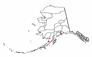
King Salmon is a census-designated place (CDP) in Bristol Bay Borough in the U.S. state of Alaska. It is 284 miles (457 km) southwest of Anchorage. As of the 2020 census the population was 307, down from 374 in 2010. It is home to Katmai National Park and Preserve. King Salmon is the borough seat of neighboring Lake and Peninsula Borough, but does not serve that purpose in its own borough, whose borough seat is in Naknek.

<span class="mw-page-title-main">Excursion Inlet, Alaska</span> Census-designated place in Alaska, United States

Excursion Inlet is a census-designated place (CDP) in Haines Borough in the U.S. state of Alaska. The population was 40 at the 2020 census, up from 12 in 2010.

<span class="mw-page-title-main">Ugashik, Alaska</span> Census-designated place in Alaska, United States

Ugashik is a census-designated place (CDP) in Lake and Peninsula Borough, Alaska, United States. The population was 4 at the 2020 census, down from 12 in 2010.

<span class="mw-page-title-main">Petersburg, Alaska</span> City in Alaska

Petersburg is a census-designated place (CDP) in and essentially the borough seat of Petersburg Borough, Alaska, United States. The population was 3,043 at the 2020 census, up from 2,948 in 2010.

<span class="mw-page-title-main">Klamath, California</span> Place in California, United States

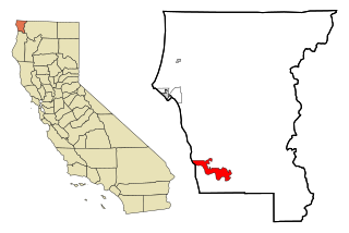
Klamath is an unincorporated community in Del Norte County, California, situated on US Route 101 inland from the mouth of the Klamath River. The population of Klamath is 632 based on US Census estimates, down from 779 recorded in the 2010 US census. For statistical purposes, the United States Census Bureau has defined Klamath as a census-designated place (CDP). Klamath is at an elevation of 30 feet (9.1 m). Klamath is located within the Yurok Indian Reservation.

Seven Oaks is a census-designated place (CDP) in Lexington County, South Carolina, United States, 8 miles (13 km) northwest of downtown Columbia, the state capital. The population of the CDP was 15,144 at the 2010 census. It is part of the Columbia Metropolitan Statistical Area.

<span class="mw-page-title-main">Copalis Beach, Washington</span> CDP in Washington, United States

Copalis Beach is a census-designated place (CDP) in Grays Harbor County, Washington, United States. The population was 447 at the 2020 census.

<span class="mw-page-title-main">Moclips, Washington</span> Census-designated place in Washington, United States

Moclips is an unincorporated community and census-designated place (CDP) in Grays Harbor County, Washington, United States. The population was 211 at the 2020 census. It is located near the mouth of the Moclips River.

<span class="mw-page-title-main">Dallesport, Washington</span> Census-designated place in Washington, United States

Dallesport is an unincorporated community and census-designated place (CDP) in Klickitat County, Washington, United States. The population was 1,328 at the 2020 census.

<span class="mw-page-title-main">Trout Lake, Washington</span> Census-designated place in Washington, United States

Trout Lake is an unincorporated community and census-designated place (CDP) in Klickitat County, Washington, United States. The population was 672 at the 2020 census. The town is notable for its organic dairy and herb farms, and as an access point to Mount Adams and the Gifford Pinchot National Forest.

<span class="mw-page-title-main">Fords Prairie, Washington</span> Census-designated place in Washington, United States

Fords Prairie is an unincorporated community and census-designated place (CDP) in Lewis County, Washington, United States. The population was 2,234 at the 2020 census.

<span class="mw-page-title-main">Chinook, Washington</span> CDP in Washington, United States

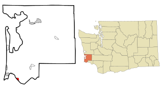
Chinook is a census-designated place (CDP) in Pacific County, Washington, United States. The population was 457 at the 2020 census.

<span class="mw-page-title-main">Naselle, Washington</span> Census-designated place in Washington, United States

Naselle is a census-designated place (CDP) in Pacific County, Washington, United States located about 23 miles (37 km) from the mouth of the Columbia River. The population was 421 at the 2020 census. The valley's Naselle River flows west into nearby Willapa Bay and then into the Pacific Ocean. Close about the town lie the evergreen-covered Willapa Hills. The river's name has been spelled Nasel and Nasal. An early settler along the river called it the Kenebec. The name comes from the Nisal Indians, a Chinookan tribe formerly residing on the river.

<span class="mw-page-title-main">Burbank, Washington</span> CDP in Washington, United States

Burbank is a census-designated place (CDP) in Walla Walla County, Washington, United States, where the Snake River meets the Columbia. The population was 3,291 at the 2010 census. Named for Luther Burbank, the city is located just east of Pasco and Kennewick, across the Snake and Columbia Rivers, respectively. Burbank is part of the Tri-Cities, WA urban area, despite being located in the Walla Walla metropolitan area.

<span class="mw-page-title-main">Touchet, Washington</span> CDP in Washington, United States

Touchet is a census-designated place (CDP) in Walla Walla County, Washington, United States. The population was 421 at the 2010 census.

<span class="mw-page-title-main">Carson, Washington</span> CDP in Washington, United States

Carson is a census-designated place in the Columbia River Gorge National Scenic Area, north of the Columbia River in Skamania County, in the southwestern part of Washington, United States. The population was 2,323 at the 2020 census.

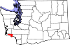
Grays River is a census-designated place (CDP) in Wahkiakum County, Washington. Grays River stands on the north bank of the lower Grays River, which flows into the Columbia River Estuary. The population was 263 as of the 2010 census. The Grays River community is part of the Naselle-Grays River Valley School District, a K-12 school district of about 670 students.

Deep River is a census-designated place (CDP) in Wahkiakum County, Washington, northwest of the town of Cathlamet and east of the city of Long Beach. In 2020, the population was estimated to be 159. The CDP includes the Svensens Landing community. The Deep River community is part of the Naselle-Grays River Valley School District, a K-12 school district of about 670 students.

<span class="mw-page-title-main">Fort Kent (CDP), Maine</span> Census-designated place in Maine, United States

Fort Kent is a census-designated place (CDP) that comprises the main village in the town of Fort Kent in Aroostook County, Maine, United States. In 2010, Fort Kent's population was 2,488 of 4,097 for the entire town.

References

  1. "2013 U.S. Gazetteer Files". census.gov. Retrieved June 18, 2014.
  2. 1 2 U.S. Geological Survey Geographic Names Information System: Altoona, Washington
  3. 1 2 3 4 "U.S. Census website". United States Census Bureau. 2011. Retrieved June 18, 2014.
  4. "Altoona, WA" . Retrieved September 13, 2020.
  5. 1 2 3 4 "Explore Census Data". data.census.gov. Retrieved May 17, 2023.