Grays River, Washington

Last updated
Grays River, Washington
CDP
USA Washington location map.svg
Red pog.svg
Grays River, Washington
Location in the state of Washington
Coordinates: 46°22′04″N123°34′53″W / 46.36778°N 123.58139°W / 46.36778; -123.58139
Country United States
State Washington
County Wahkiakum
Area
[1]
  Total20.191 sq mi (52.293 km2)
  Land20.125 sq mi (52.122 km2)
  Water0.066 sq mi (0.171 km2)  0.33%
Elevation
[2]
161 ft (49 m)
Population
 (2010) [3]
  Total263 [3]
 Population as of 2010 U.S. Census
Time zone UTC−8 (PST)
  Summer (DST) UTC−7 (PDT)
ZIP code
98621
Area code 360
FIPS code 53-28450
GNIS feature ID2584977

Grays River is a census-designated place (CDP) in Wahkiakum County, Washington. Grays River stands on the north bank of the lower Grays River, which flows into the Columbia River Estuary. The National Register of Historic Places-listed Grays River Covered Bridge crosses the Grays River in the community. It is the only such bridge still in use in Washington. [4] The population was 263 as of the 2010 census. [3] The Grays River community is part of the Naselle-Grays River Valley School District, a K-12 school district of about 670 students.

Contents

Geography

Grays River is located at 46°22′04″N123°34′53″W / 46.36778°N 123.58139°W / 46.36778; -123.58139 (46.367836, -123.581335). [1]

According to the United States Census Bureau, the CDP has a total area of 20.19 square miles (52.3 km2), of which 20.13 square miles (52.1 km2) of it is land and 0.07 square miles (0.18 km2) of it (0.33%) is water.

Climate

Grays River has a subtropical Mediterranean climate (Köppen Csb). [5] The average temperature for the year in Grays River is 50.2 °F (10.1 °C). The warmest month, on average, is August with an average temperature of 61.6 °F (16.4 °C). The coolest month on average is January, with an average temperature of 40.1 °F (4.5 °C). The highest recorded temperature in Grays River is 105 °F (41 °C), while the lowest recorded temperature is 2 °F (−17 °C).

Being that Grays River is located only 23 miles (37 km) from the coast and there are no significant hills or mountains between it and the coast, Grays River receives a great deal of precipitation. The average annual precipitation is 107.7 in (2,740 mm). Measurable precipitation falls on Grays River an average of 192 days a year. The most precipitation in one month was 35.2 in (890 mm). The maximum daily rainfall was 6.4 in (160 mm). Average annual snowfall is 4.9 inches (12.4 cm) with the average number of days with snow is 1.7. The highest monthly snowfall was 27 inches (69 cm).

Climate data for Grays River, Washington
MonthJanFebMarAprMayJunJulAugSepOctNovDecYear
Record high °F (°C)65
(18)
74
(23)
81
(27)
88
(31)
97
(36)
100
(38)
105
(41)
105
(41)
101
(38)
87
(31)
72
(22)
66
(19)
105
(41)
Average high °F (°C)47.2
(8.4)
51.2
(10.7)
54.1
(12.3)
58.0
(14.4)
63.6
(17.6)
68.0
(20.0)
73.4
(23.0)
74.0
(23.3)
71.7
(22.1)
62.5
(16.9)
52.5
(11.4)
47.1
(8.4)
60.3
(15.7)
Average low °F (°C)33.1
(0.6)
33.6
(0.9)
35.0
(1.7)
37.4
(3.0)
42.0
(5.6)
46.4
(8.0)
49.5
(9.7)
49.3
(9.6)
45.5
(7.5)
40.2
(4.6)
36.6
(2.6)
33.9
(1.1)
40.2
(4.6)
Record low °F (°C)4
(−16)
3
(−16)
19
(−7)
22
(−6)
29
(−2)
32
(0)
34
(1)
34
(1)
29
(−2)
22
(−6)
9
(−13)
2
(−17)
2
(−17)
Average precipitation inches (mm)16.7
(420)
11.6
(290)
11.6
(290)
7.7
(200)
4.8
(120)
3.6
(91)
1.8
(46)
2.6
(66)
4.5
(110)
9.6
(240)
16.1
(410)
17.2
(440)
107.7
(2,740)
Average snowfall inches (cm)2.2
(5.6)
0.9
(2.3)
0.2
(0.51)
0
(0)
0
(0)
0
(0)
0
(0)
0
(0)
0
(0)
0
(0)
0.6
(1.5)
1.0
(2.5)
4.9
(12)
Average precipitation days2118211916138810162121192
Average snowy days0.80.6000000000.10.21.7
Source: WeatherBase [5]

Demographics

Historical population
CensusPop.Note
2010 263
2020 248−5.7%
2010 U.S. Census

2020 census

As of the 2020 census, there were 248 people, 135 housing units, and 104 families. The racial makeup was 218 White people, 3 African Americans, 3 Native Americans, 3 Asians, 0 Pacific Islanders, and 21 people from two or more races. 7 people were Hispanic or Latino. [6]

The ancestry of Grays River was 14.5% English, 6.6% Irish, 3.5% German, and 2.6% Norwegian. [6]

The median age in Grays River was 68.9 years old. 63.2% of the population were 65 or older, with 41.7% from 65 to 74 years, 8.8% from 75 to 84, and 12.7% were 85 or older. [6]

The median household income was $54,048, families had $64,583, and non-families had $52,857. 0.0% of the population were in poverty. [6]

2010 census

As of the census of 2010, [3] there were 263 people, 110 households, and 83 families residing in the CDP. The population density was 13.03 people per square mile (5.03 people/km2). There were 128 housing units at an average density of 6.34 per square mile (2.45/km2). The racial makeup of the CDP was 94.3% White, 0.4% African American, 0.4% Native American, 1.1% Asian, 0.0% Pacific Islander, 1.5% from other races, and 2.3% from two or more races. Hispanic or Latino of any race were 2.7% of the population.

There were 110 households, out of which 19.1% had children under the age of 18 living with them, 68.2% were married couples living together, 6.4% had a female householder with no husband present, and 24.5% were non-families. 20.9% of all households were made up of individuals, and 13.6% had someone living alone who was 65 years of age or older. The average household size was 2.39 and the average family size was 2.71.

In the CDP, the age distribution of the population shows 18.3% under the age of 18, 5.7% from 18 to 24, 13.3% from 25 to 44, 38.0% from 45 to 64, and 24.7% who were 65 years of age or older. The median age was 55.5 years. For every 100 females, there were 103.9 males. For every 100 females age 18 and over, there were 112.9 males.

Related Research Articles

<span class="mw-page-title-main">Markleeville, California</span> Census-designated place in California, United States

Markleeville is a census-designated place (CDP) and the county seat of Alpine County, California, United States. The population was 191 at the 2020 census, down from 210 at the 2010 census.

<span class="mw-page-title-main">Yosemite Valley, California</span> Census-designated place in California, United States

Yosemite Valley is a census-designated place (CDP) in Mariposa County, California, United States. It consists of the developed area of Yosemite Village and the other areas of the Yosemite Valley in Yosemite National Park. The population was 337 at the 2020 census.

<span class="mw-page-title-main">Angwin, California</span> Census-designated place in California, United States

Angwin is a census-designated place (CDP) in Napa County, California, best known as the site of Pacific Union College. It is part of the northern San Francisco Bay Area. The population was 3,051 at the 2010 census. Its area code is 707. Its two zip codes are 94508 and 94576. It is in the Pacific time zone.

<span class="mw-page-title-main">Ben Lomond, California</span> Census-designated place in Santa Cruz County, California, United States

Ben Lomond is a census-designated place (CDP) in Santa Cruz County, California, United States, and also the name of the mountain to the west. The CDP includes the communities of Glen Arbor and Brackney. The population was 6,337 at the 2020 census.

<span class="mw-page-title-main">Interlaken, California</span> Census-designated place in California, United States

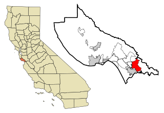
Interlaken is a census-designated place (CDP) in Santa Cruz County, California, United States. The population was 7,368 at the 2020 census.

<span class="mw-page-title-main">Hayfork, California</span> Census-designated place in California, United States

Hayfork is a census-designated place (CDP) in Trinity County, California, United States. Its population is 2,324 as of the 2020 census, down from 2,368 from the 2010 census.
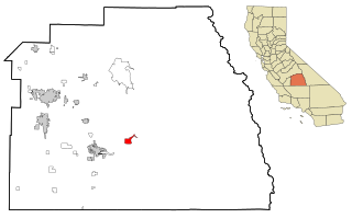
<span class="mw-page-title-main">Weaverville, California</span> Census-designated place in California, United States

Weaverville is a census-designated place and the county seat of Trinity County, California, United States. Its population is 3,667 as of the 2020 census, up from 3,600 from the 2010 census.

<span class="mw-page-title-main">Pinehurst, Massachusetts</span> Census-designated place in Massachusetts, United States

Pinehurst is an unincorporated village and census-designated place (CDP) in the town of Billerica, Middlesex County, Massachusetts, United States. The population was 7,368 at the 2020 census. It is in the southeastern part of town along Massachusetts Route 3A.

<span class="mw-page-title-main">Sun River, Montana</span> CDP in Montana, United States

Sun River is a census-designated place (CDP) in Cascade County, Montana, United States. The population was 124 at the 2010 census. It is part of the Great Falls, Montana Metropolitan Statistical Area.

<span class="mw-page-title-main">Dover Beaches South, New Jersey</span> Populated place in Ocean County, New Jersey, US

Dover Beaches South, more commonly known as Ortley Beach, is an unincorporated community and census-designated place (CDP) located within Toms River, in Ocean County, in the U.S. state of New Jersey. As of the 2010 United States Census, the CDP's population was 1,209. Dover Beaches South is situated on the Barnegat Peninsula, a long, narrow barrier peninsula that separates Barnegat Bay from the Atlantic Ocean.

<span class="mw-page-title-main">North Beach Haven, New Jersey</span> Populated place in Ocean County, New Jersey, US

North Beach Haven is an unincorporated community and census-designated place (CDP) constituting a part of the Jersey Shore community of Long Beach Township, in southern Ocean County, in the U.S. state of New Jersey. The CDP is situated on Long Beach Island, a barrier island separating Barnegat Bay from the Atlantic Ocean.

<span class="mw-page-title-main">Numidia, Pennsylvania</span> Census-designated place in Pennsylvania, United States

Numidia is a census-designated place (CDP) in Columbia County, Pennsylvania, United States. It is part of Northeastern Pennsylvania. The population was 244 at the 2010 census. It is part of the Bloomsburg-Berwick metropolitan area.
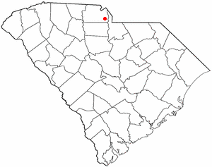
<span class="mw-page-title-main">Aberdeen Gardens, Washington</span> CDP in Washington, United States

Aberdeen Gardens is a census-designated place (CDP) in Grays Harbor County, Washington, United States. The population was 279 at the 2010 census.

<span class="mw-page-title-main">Brady, Washington</span> Census-designated place in Washington, United States

Brady is a census-designated place (CDP) in Grays Harbor County, Washington, United States. The population was 676 at the 2010 census.

<span class="mw-page-title-main">Junction City, Washington</span> Census-designated place in Washington, United States

Junction City is a census-designated place (CDP) in Grays Harbor County, Washington, United States. The population was 18 at the 2010 census.

<span class="mw-page-title-main">Satsop, Washington</span> Census-designated place in Washington, United States

Satsop is a census-designated place (CDP) in Grays Harbor County, Washington, United States. The population was 675 at the 2010 census, up from 619 at the 2000 census.

<span class="mw-page-title-main">Naselle, Washington</span> Place in Washington, United States

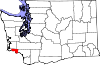
Naselle is a census-designated place (CDP) in Pacific County, Washington, United States located about 23 miles from the mouth of the Columbia River. The population was 419 at the 2010 census. The valley's Naselle River flows west into nearby Willapa Bay and then into the Pacific Ocean. Close about the town lie the evergreen-covered Willapa Hills. The river's name has been spelled Nasel and Nasal. An early settler along the river called it the Kenebec. The name comes from the Nisal Indians, a Chinookan tribe formerly residing on the river.
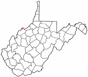
<span class="mw-page-title-main">Waller, Washington</span> CDP in Washington, United States

Waller is a census-designated place (CDP) in Pierce County, Washington, United States. The population was 8,189 at the 2020 census. The population has seen significant growth in the last decade.

Deep River is a census-designated place (CDP) in Wahkiakum County, Washington, northwest of the town of Cathlamet and east of the city of Long Beach. In 2020, the population was estimated to be 159. It is the current residence of Krist Novoselic, the bassist for early 1990s grunge rock band, Nirvana. The CDP includes the Svensens Landing community. The Deep River community is part of the Naselle-Grays River Valley School District, a K-12 school district of about 670 students.

Altoona is a census-designated place (CDP) in Wahkiakum County, Washington, approximately 27 miles northwest of the town of Cathlamet. The population was 39 as of the 2010 census. The CDP includes the communities of Carlson Landing and Dahlia.

References

  1. 1 2 "2013 U.S. Gazetteer Files". census.gov. Retrieved 21 June 2014.
  2. "USGS—Grays River, Washington" . Retrieved 21 June 2014.
  3. 1 2 3 4 "U.S. Census website". United States Census Bureau. 2011. Retrieved 21 June 2014.
  4. "Rehabilitation of the historic Grays River Covered Bridge is celebrated at a rededication on September 30, 1989". historylink.org. 29 December 2006. Retrieved 21 June 2014.
  5. 1 2 "Climate of Grays River". weatherbase.com. Retrieved 21 June 2014.
  6. 1 2 3 4 "Explore Census Data". data.census.gov. Retrieved 2023-05-16.