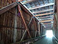
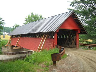
A covered bridge is a timber-truss bridge with a roof, decking, and siding, which in most covered bridges create an almost complete enclosure. The purpose of the covering is to protect the wooden structural members from the weather. Uncovered wooden bridges typically have a lifespan of only 20 years because of the effects of rain and sun, but a covered bridge can last over 100 years. In the United States, only about 1 in 10 survived the 20th century. The relatively small number of surviving bridges is due to deliberate replacement, neglect, and the high cost of restoration.
Grays River is a tributary of the Columbia River, approximately 30 miles (48 km) long, in southwestern Washington in the United States. One of the last tributaries of the Columbia on the Washington side, it drains an area of low hills north of the mouth of the river.

A truss bridge is a bridge whose load-bearing superstructure is composed of a truss, a structure of connected elements, usually forming triangular units. The connected elements, typically straight, may be stressed from tension, compression, or sometimes both in response to dynamic loads. There are several types of truss bridges, including some with simple designs that were among the first bridges designed in the 19th and early 20th centuries. A truss bridge is economical to construct primarily because it uses materials efficiently.

The Astoria–Megler Bridge is a steel cantilever through-truss bridge in the Pacific Northwest region of the United States that spans the lower Columbia River. It carries a section of U.S. Route 101 from Astoria, Oregon, to Point Ellice near Megler, Washington. Opened in 1966, it is the longest continuous truss bridge in North America.

The Columbia Bridge is a covered bridge, carrying Columbia Bridge Road over the Connecticut River between Columbia, New Hampshire and Lemington, Vermont. Built in 1911–12, it is one of only two New Hampshire bridges built with Howe trusses, and is one of the last covered bridges built in the historic era of covered bridge construction in both states. It was listed on the National Register of Historic Places in 1976.

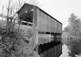
The Mount Orne Bridge is a covered bridge over the Connecticut River between Lancaster, New Hampshire, and Lunenburg, Vermont. It joins Elm Street in South Lancaster with River Road in Lunenburg. Built in 1911, it is one of two Howe truss bridges across the Connecticut River. It was listed on the National Register of Historic Places in 1976.

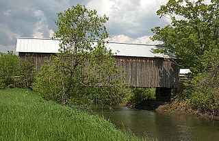
Rexleigh Bridge is a wooden covered bridge over the Batten Kill in Washington County, New York. It is one of 29 historic covered bridges in New York State.

The Belknap Bridge crosses the McKenzie River near the unincorporated community of Rainbow in Lane County, Oregon, United States. It is approximately three miles west of the town of McKenzie Bridge which is named after the bridge. It is the fourth covered bridge built on the site. The bridge is well maintained and open to traffic. The Belknap Bridge is listed on the National Register of Historic Places.

The Goodpasture Bridge spans the McKenzie River near the community of Vida in Lane County, Oregon, United States. It is the second longest covered bridge and one of the most photographed covered bridges in the state. The Goodpasture Bridge is listed on the National Register of Historic Places.

Staats Mill Covered Bridge, also known as Tug Fork Covered Bridge, is a historic wooden covered bridge near Ripley in Jackson County, West Virginia, United States. Built in 1887, the Staats Mill Covered Bridge originally crossed the Tug Fork of Big Mill Creek and was named for Enoch Staats' water-powered mill.

The McColly Covered Bridge is a historic wooden covered bridge in western Logan County, Ohio, United States. Located in Washington Township near the community of Bloom Center, it is one of two remaining covered bridges in Logan County. It carries County Road 13 over the Great Miami River, approximately 5 miles (8.0 km) south of its source at Indian Lake.

Watson Settlement Bridge was a historic covered bridge in eastern Littleton, Maine, United States. Built in 1911, it was one of the youngest of Maine's few surviving covered bridges. It formerly carried Framingham Road over the Meduxnekeag River, but was closed to traffic, the road passing over a modern bridge to its south. It was listed on the National Register of Historic Places in 1970. It was destroyed by fire on July 19, 2021, and subsequently delisted from the National Register in 2023.
The Hancock–Greenfield Bridge is a historic covered bridge carrying Forest Road over the Contoocook River at the town line between Hancock and Greenfield, New Hampshire. The New Hampshire Department of Transportation covered bridge database refers to it as County Bridge. Built in 1937, it is the first wooden covered bridge in the northeastern United States to use modern engineering techniques. The bridge was listed on the National Register of Historic Places in 1981.

The Covered Bridge in Cedarburg, Ozaukee County, Wisconsin, United States, is one of the last remaining covered bridges in that state, which once had about 40 covered bridges. Built in 1876 to cross Cedar Creek, the bridge is 120 feet (37 m) long and is made of pine with oak lattices. It was listed on the National Register of Historic Places in 1973 and is now used only for pedestrian traffic.
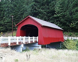
The Fisher School Bridge is a covered bridge in Lincoln County in the U.S. state of Oregon. The 72-foot (22 m) Howe truss structure crosses a stream called Five Rivers near the rural community of Fisher in the Central Oregon Coast Range. Previously closed to vehicles, the bridge was renovated on a new foundation adjacent to the original position.

The Taftsville Covered Bridge is a timber-framed covered bridge which spans the Ottauquechee River in the Taftsville village of Woodstock, Vermont, in the United States. Built in 1836 and exhibiting no influence from patented bridge designs, it is among the oldest remaining covered bridges both in Vermont and the nation as a whole.
The Howe Covered Bridge is a historic covered bridge carrying Belknap Brook Road across the White River in Tunbridge, Vermont, just east of Vermont Route 110. Built in 1879, it is one of five surviving bridges in the town, one of the highest concentrations of covered bridges in the state. It was listed on the National Register of Historic Places in 1974.

The Mederville Bridge is a historic structure located in the unincorporated community of Mederville, Iowa, United States. It spans the Volga River for 156 feet (48 m). This is one of only a few open spandrel arch bridges constructed in Iowa. Designed by the Marsh Engineering Company of Des Moines, it replaced a covered timber Howe truss bridge. Clayton County rejected all of the original bids to build the structure when they all came in too high. Six companies bid a second time on the project, and F. E. Marsh and Company of Des Moines won. They completed in the bridge in 1918 for $17,454.32. It was listed on the National Register of Historic Places in 1998.

The East Shoreham Covered Railroad Bridge is a historic covered bridge spanning the Lemon Fair River near East Shoreham, Vermont. Built in 1897 by the Rutland Railroad Company, it is the state's only surviving example of a wooden Howe truss railroad bridge. It was listed on the National Register of Historic Places in 1974.
The River Road Covered Bridge was a historic covered bridge, carrying Veilleux Road across the Missisquoi River in Troy, Vermont. Built in 1910, the Town lattice truss was the only surviving covered bridge in Troy from the historic period of covered bridge construction when it burned on February 6, 2021. It also exhibited some distinctive variations in construction from more typical Town lattices. It was listed on the National Register of Historic Places in 1974.