Altstadt (Zurich)

Last updated
Altstadt
Kreis 1
District 1
District
CHE Zurich 1 rechts der Limmat Flag.svg
CHE Zurich 1 rechts der Limmat ZH COA.svg
Karte Zurcher Stadtkreis 1.png
Coordinates: 47°22′12″N8°32′31″E / 47.370°N 8.542°E / 47.370; 8.542
CountrySwitzerland
Canton Zürich
City Zürich
Area
  Total1.8 km2 (0.7 sq mi)
Population
 (31. Dec. 2015)
  Total5,617 [1]
  Density3,120/km2 (8,100/sq mi)
District Number1
Quarters Rathaus
Hochschulen
Lindenhof
City

The Altstadt (German for "old town") in the Swiss city of Zurich encompasses the area of the entire historical city before 1893, before the incorporation of what are now districts 2 to 12 into the municipality, over the period 1893 to 1934. Die Altstadt approximately corresponds to the area enclosed by the former city ramparts, and is today within the administrative area of the city called Kreis 1 (District 1).

Contents

With a population of 5,617 (as of 2015), it houses about 1.4% of the city's total population.

Administratively, District 1 is divided into four parts or quarters by the Zürich statistical office, Rathaus (town hall), Hochschulen (universities), Lindenhof ("lime trees courtyard") and City. Lindenhof and Rathaus correspond to the parts of the medieval city left (west) and right (east) of the Limmat, respectively, while City and Hochschulen include the area of the Early Modern city west and east of the medieval walls, respectively.

The city of Zurich on the 1881 Siegfriedkarte (city area highlighted), after the construction of the Limmatquai and the train station, but before the construction of Uraniastrasse, and of the lakeside quais with Quaibrucke (hover mouse over map for labels). Zuerich Altstadt Siegfriedkarte 1881.jpgZürich Main StationMünsterbrückeRathausbrückeBahnhofbrückeOld Botanical GardenSchanzengrabenPredigerkircheNeumarktNiederdorfCentralOberdorfZeughausSt. PeterAugustinerklosterRennwegEidgenössisches PolytechnikumBellevuePfauenStadelhofenTalackerBürkliplatzEngeHottingenKasernenareal
The city of Zürich on the 1881 Siegfriedkarte (city area highlighted), after the construction of the Limmatquai and the train station, but before the construction of Uraniastrasse, and of the lakeside quais with Quaibrücke (hover mouse over map for labels).
Map of Zurich in 1705 (north is left). Altstadt corresponds to the fortified area and immediately adjacent parts. Zuerich1705.jpg
Map of Zürich in 1705 (north is left). Altstadt corresponds to the fortified area and immediately adjacent parts.

Lindenhof

Altstadt: St. Peter church St Peter Zuerich.jpg
Altstadt: St. Peter church

Der Lindenhof ("The lime trees courtyard") quarter corresponds to the mindere Stadt, the smaller but more prestigious half of the medieval town left of the river. This is the oldest core of the city, with settlement traces dating to pre-Roman (La Tène) times, and fortified as the Roman Vicus Turicum, a Roman customs station with a surrounding civilian settlement, in the final decades of the 1st century BC.

The Lindenhof hill itself is the site of the Roman castle at the location of the Celtic Oppidum Zürich-Lindenhof , rebuilt in Carolingian times but derelict by the 13th century, when it was used as a source for building stone for the first stone houses of rich burghers of the recently reichsfrei city. The Schipfe quarter at the Limmat below the Lindenhof is the site of the Roman vicus, with traces of a hypocaustum nearby the Münsterhof excavated. St. Peter church was the parish church of the medieval city, built on the site of an earlier temple to Jupiter.

The Rennweg street below the Lindenhof hill was the main street of the medieval city, entering by the Rennweg gate through the western city wall which is now marked by the course of Bahnhofstrasse . Augustinergasse is a small street leading from St. Peterhofstatt situated at the St. Peter church, passing the former Augustinians monastery below the Lindenhof hill, towards the Kecinstürlin gate at the southern Fröschengraben moat, Bahnhofstrasse as of today.

Zunfthaus zur Meisen at Münsterhof plaza near Fraumünster church houses the porcelain and faience collection of the Swiss National Museum. Lindenhof also contains the former Augustinian abbey, and formerly the Oetenbach nunnery north of the Lindenhof hill, demolished in 1903 to make way for the Uraniastrasse as part the partially built «Urania-axis» Sihlporte–Uraniastrasse–Zähringerplatz by Gustav Gull, and the Urania Sternwarte.

Fraumünster

The Fraumünster ("women's minster") abbey ruled the town until the 1336 "guild revolution" of Rudolf Brun and which remained highly influential until Zwingli's Reformation. [2]

Rathaus

Limmatquai with guild houses and Grossmunster ZH Grossmuenster Limmat.JPG
Limmatquai with guild houses and Grossmünster
Neumarkt and Grimmenturm Grimmenturm - Neumarkt Zurich 2014-10-29 11-10-28 (P7800).JPG
Neumarkt and Grimmenturm
Guild house <<Haue>> at Limmatquai, Rathaus at the left side (2008) Zurich - Limmatquai - Zum Kambel IMG 1115.jpg
Guild house «Haue» at Limmatquai, Rathaus at the left side (2008)
Niederdorf: Stussihofstatt, guild house <<zur Schneidern>> (tailors) at the left side, and Restaurant Johanniter (right side) Zurich - Niederdorf - Stussihofstatt - zur Schnidern IMG 1375.jpg
Niederdorf: Stüssihofstatt, guild house «zur Schneidern» (tailors) at the left side, and Restaurant Johanniter (right side)

The Rathaus quarter is named for the town hall, built in the 1690s. It is the part of the medieval town on the right side of the Limmat, separated by the Hirschengraben from the Hochschulen quarter to the east, and delimited by the Bellevue and Central squares to the south and north, respectively. As such, it includes the Limmatquai as well as the Niederdorf (downstream of the Kirchgasse) and the Oberdorf (upstream of the Kirchgasse). The historical name of this eastern half of the medieval town was "greater town" (mehrere Stadt), contrasting with the "lesser town" (mindere Stadt), the western half along the left river bank.

Limmatquai

The Limmatquai was built along the right side of the Limmat, running from Central to Bellevue. It was built in the 19th century, connecting various earlier quais built into the Limmat. The current right bank is some 28 m west of the medieval river's. The quai was constructed from 18231859 from Bellevue to the Rathaus, in 18351836 from the Rathaus to the Wasserkirche and 18351839 the portion from the Wasserkirche to Bellevue, formerly called Sonnenquai. At the Limmatquai are located some guild houses, as Zunfthaus zur Zimmerleuten, Zunfthaus zur Haue, Zunfthaus zum Rüden and Zunfthaus zur Saffran. Zürich tram routes 4 and 15 run along the Limmatquai, serving the stops Helmhaus, Rathaus and Rudolf-Brun-Brücke. The quai was one of the main routes through the old town before it was freed from traffic in 2004. The bridges passed by the Limmatquai, south to north, are:

north of Limmatquai:

Niederdorf

The Niederdorf (lit.: "low village") was the least developed part of the medieval city. It properly includes just the north-eastern corner, between Mühlegasse and Central, but the term was extended to the whole part of the mehrere Stadt north of the town hall, i.e. for the entire length of the Niederdorfstrasse, or even including the parts north of the Kirchgasse.[ citation needed ]

So defined,[ clarification needed ] the Niederdorf includes Rindermarkt and Neumarkt , Froschaugasse and the area of the medieval Jewish quarter, the Predigerkirche (the former Blackfriars' monastery) at Zähringerplatz (historically the city hospital, now housing the city library) and the Zähringerstrasse.

Münstergasse

The mehrere Stadt between the Niederdorf and the Oberdorf (between Rathaus and Kirchgasse) includes the Münstergasse, Obere Zäune, Untere Zäune and the Barfüsserkloster (the former Franciscan abbey) as well as a number of alleys leaving Münstergasse: Marktgasse, Spiegelgasse, Krebsgasse, Ankengasse, Römergasse and Kirchgasse.[ citation needed ]

Grossmünster

Predigerkirche

Initially the church of the Predigerkloster (Dominican monastery), it became after the Reformation in Switzerland the parish church of Niederdorf respectively Neumarkt, and owns since 1900 the tallest church tower of Zürich. [3]

Oberdorf

The Oberdorf (lit.: "upper village") proper is the mehrere Stadt south of the Grossmünster, along the Oberdorfstrasse, between Kirchgasse and Rämistrasse.

Hochschulen

University main building, with the Predigerkirche, the Niederdorf and the Limmat in the background. UZZ-01.JPG
University main building, with the Predigerkirche, the Niederdorf and the Limmat in the background.
1890 etching of Grandhotel Bellevue at Bellevueplatz and the lakeside: Limmatquai downstream the Limmat, Quaibrucke crossing to Burkliplatz, and Utoquai alongside Sechselautenplatz. Bellevue 1890.jpg
1890 etching of Grandhotel Bellevue at Bellevueplatz and the lakeside: Limmatquai downstream the Limmat, Quaibrücke crossing to Bürkliplatz, and Utoquai alongside Sechseläutenplatz.
Aerial view (1961) ETH-BIB-Zurich-Altstadt-LBS H1-022544.tif
Aerial view (1961)
Central square, seen from Lindenhof hill, Limmatquai to the right. Zurich - Central IMG 1990.jpg
Central square, seen from Lindenhof hill, Limmatquai to the right.

Hochschulen (universities) is wedged between Hirschengraben (the historical course of the eastern moat) and Rämistrasse, corresponding to the area taken up by the eastern fortifications of the 17th century ramparts (destroyed following the 1839 Züriputsch), the hillside now holding the main buildings of both ETH Zurich (built 1861 to 1864 under Gustav Zeuner) and University of Zurich (built 1914 under Karl Moser), at the sites of the Kronen Bollwerk and Schönenberg Bollwerk ramparts, respectively. Hochschulen borders on District 6 (Unterstrass and Oberstrass) to the north, on District 7 (Fluntern and Hottingen) to the east and on District 8 (Mühlebach and Seefeld) to the south.

Hochschulen in its southern end also includes the Bellevue and Sechseläuten squares as well as the theater and opera house at Stadelhoferplatz and the Stadelhofen train station. Stops of the Zürich tram system in the Hochschulen quarter are: Central, ETH/Universitätsspital , Kantonsschule, Kunsthaus, Neumarkt , Bellevue, Opernhaus and Stadelhofen. Line 9 follows Rämistrasse which separates Hochschulen from Fluntern, line 3 follows Hirschengraben and Seilergraben (the historical eastern moat), which separates it from the Rathaus quarter. The Polybahn funicular connects Central and the ETH Zurich main building.

Central

The Central square at the northern border between Rathaus and Hochschulen quarters is a major junction of the Zürich tram system, served by lines 3, 4, 6, 7, 10 and 15 besides buses 31 and 46. Formerly called Leonhardsplatz, it was renamed after the Hotel Central built in 1883.

Pfauen

Situated at Heimplatz, vernacularly called the Pfauen, are the theatre Schauspielhaus Zürich and the art museum Kunsthaus Zürich.

Bellevue

The Bellevueplatz, a square at the southern border between the Rathaus quarter and the southern end of the Hochschulen quarter, right next to the lake outflow, is a major junction of the Zürich tram system, served by lines 2, 4, 5, 8, 9, 11 and 15 besides buses 912 and 916. It is situated at the lakeside, just north of Sechseläutenplatz. It is named for the Grandhotel Bellevue built in 1856, and is the nodal point of the quaysides that were built between 1881 and 1887 crossing the Quaibrücke towards Bürkliplatz and General-Guisan-Quai.

Stadelhofen

South of Bellevue are the squares Sechseläutenplatz and Stadelhofenplatz. Stadelhofen was an estate just south of the southeasternmost bastion, the Stadelhofen Bollwerk, whilst Sechseläutenplatz takes its name from the Sechseläuten, a traditional Zürich festival that is celebrated there.

Stadelhofen station, on Stadelhofenplatz, is an important stop of the Zürich S-Bahn lines to Uster, Rapperswil-Jona and Winterthur as well as the terminal of the Forchbahn (S18) line serving Zumikon and Esslingen. The Zürich Opera House is situated at the southern end of the Sechseläutenplatz.

City

City is the area west of the Bahnhofstrasse, delimited by the Sihl and the Schanzengraben , the moat of the 17th century ramparts. It includes the Paradeplatz, Zürich Hauptbahnhof, the Swiss National Museum and the Platzspitz park (formerly Limmatspitz). It comprises the tram stops Bürkliplatz , Paradeplatz, Rennweg, Bahnhofstrasse / Bahnhofplatz / Bahnhofquai, Löwenplatz, Sihlstrasse and Bahnhof Selnau. City borders on District 2 (Enge) to the southwest, and on Districts 4 and 5 (Aussersihl) to the northwest.

Platzspitz

1724 view of the northern end of town, with the Platzspitz in the foreground, at the time a shooting-range. Ansicht Zuerich Herrliberge.jpg
1724 view of the northern end of town, with the Platzspitz in the foreground, at the time a shooting-range.

Platzspitz (formerly Platzpromenade, Limmatspitz) is a park at the confluence of the two rivers of Zürich; the Limmat and the Sihl.

In medieval times, the area situated north of the city was used as pasture. In the early 15th century it was made into a shooting-range, and in the 16th to 17th centuries, Schützenfeste were held there. A remnant of these can be found in the contemporary Knabenschiessen shooting contest.

During the 1990s, the long-practised official tolerance of drug users there from throughout Central Europe has been the subject of much worldwide media interest.

Hauptbahnhof

The Limmat, Bahnhofbrucke, Bahnhofquai and Hauptbahnhof seen from Walche-Brucke looking upstream 7139-7140 - Zurich - Limmat viewed from Walche-Brucke.jpg
The Limmat, Bahnhofbrücke, Bahnhofquai and Hauptbahnhof seen from Walche-Brücke looking upstream

Bahnhofstrasse

Paradeplatz Zurich Paradeplatz.jpg
Paradeplatz
Burkliplatz, St. Peter and Fraumunster church towers in the background Zurichsee - Burkliplatz IMG 2143.JPG
Bürkliplatz, St. Peter and Fraumünster church towers in the background

Bürkliplatz

Bürkliplatz is a square and stop of the Zürich tram system (lines 2, 4, 8, 9, 11 and buses 161, 165), situated at the southern end of the Bahnhofstrasse, and west of the Bellevue square, with which it is connected by the Quaibrücke . The lakeshore quay connecting the square with Lake Zurich is named General-Guisan-Quai , after Henri Guisan. From the Bürkliplatz landing gate, Zürichsee-Schifffahrtsgesellschaft boat services leave for Thalwil, Rapperswil, Schmerikon, Erlenbach and down the Limmat to Zürich Landesmuseum. Bürkliplatz is named for Arnold Bürkli (18331894), the engineer responsible for the construction of the city's quays.

Schanzengraben

On its remains at «zur Katz» ramparts, the Old Botanical Garden is located.

Selnau

Selnau (from earlier Sellnau, Seldnau) was historically an estate west of the city, which came to lie between the north-western moat (Schanzengraben) and the Sihl. Together with the Gessnerallee, Selnaustrasse and Sihlhölzlistrasse running along the right bank of the Sihl, it is part of the City quarter even though strictly situated outside the city ramparts. Today, Zürich Selnau railway station is a stop on the line of the Uetlibergbahn, running from Zürich Hauptbahnhof to the Sihltal (S4) and to the Uetliberg (S10). The SWX Swiss Exchange building is located in Selnau. The museum Haus Konstruktiv is located in a former power station near Selnau train station.

See also

Literature

Related Research Articles

<span class="mw-page-title-main">Rennweg (Zürich)</span>

Rennweg is a medieval main road and is today part of the inner-city pedestrian zone of Zürich, Switzerland. A rennweg was in the medieval German speaking territories a street where horses were moved. Once, it was one of the nodal points of road and public transportation. Today, as well as the Limmatquai, as well as Augustinergasse, it is a section of the southern extension of the Seeuferanlage promenades that were built between 1881 and 1887. Rennweg is one of the best known visitor attractions of the oldest area of the city of Zürich.

<span class="mw-page-title-main">Zürich Town Hall</span> Town hall in Zürich, Switzerland

The Rathaus in Zürich, Switzerland is Zürich's Town Hall. The Rathaus was built from 1694-1698. It served as the seat of government and administration of the Republic of Zürich until 1798. The canton of Zürich owns it since 1803, and it houses both legislative chambers, the cantonal parliament as well as the City Parliament. It must be distinguished from the Stadthaus, which is the seat of the city's executive government, the City Council and its administration.

Zürich was an independent (reichsfrei) city or city-state from 1218 to 1798. The town was fortified with a city wall from the 13th to the 17th century, and with more elaborate ramparts constructed in the 17th to 18th century and mostly demolished in the 1830s to 1870s.

<span class="mw-page-title-main">Schipfe</span>

Schipfe is a residential district in Zürich, Switzerland, located on the eastern slope of the Lindenhof, one of the oldest parts of the Helvetii Oppidum Zürich-Lindenhof, by the river Limmat. Historians and the Weinplatz suggest that the district was part of the former civilian harbour of the Celtic-Roman Turicum.

<span class="mw-page-title-main">Lindenhof hill</span> Moraine hill and public square in Zürich, Switzerland

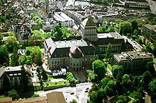
The Lindenhof is a moraine hill and a public square in the historic center of Zürich, Switzerland. It is the site of the Roman and Carolingian era Kaiserpfalz around which the city has historically grown. The hilltop area—including its prehistoric, Roman, and medieval remains—is listed as a Swiss heritage site of national significance.

<span class="mw-page-title-main">Augustinergasse</span>

Augustinergasse is a medieval lane that today is part of the innercity pedestrian zone of Zürich, Switzerland. It is named after the former Augustinian Abbey that is now Augustinerkirche, the former church of the convent that was disestablished in 1525. Once, it was one of the nodal points of road and public transportation between Münsterhof, St. Peterhofstatt, the present Münzplatz plaza at the former abbey, and one of the gates and fortifications of the medieval town walls. Today, as well as the Limmatquai, Augustinergasse is a section of the southern extension of the Seeuferanlage promenades that were built between 1881 and 1887, and one of the best known visitor attractions of the oldest area of the city of Zürich.

<span class="mw-page-title-main">Münsterhof</span> Town square in Zürich, Switzerland

Münsterhof is a town square situated in the Lindenhof quarter in the historical center of Zürich, Switzerland. It is the largest town square within the Altstadt of Zürich, and is surrounded by medieval buildings. The area forms part of the southern extension of the Quaianlagen promenades along Zürich's lakefront.

<span class="mw-page-title-main">Turicum</span> Former Gallo-Roman settlement in Switzerland

Turicum was a Gallo-Roman settlement at the lower end of Lake Zurich, and precursor of the city of Zürich. It was situated within the Roman province of Germania Superior) and near the border to the province of Raetia; there was a tax-collecting point for goods traffic on the waterway Walensee–Obersee-Zürichsee–Limmat–Aare–Rhine.

<span class="mw-page-title-main">Bellevueplatz</span> Town square in Zürich, Switzerland

Bellevueplatz is a town square in Zürich, Switzerland built in 1856. Named after the former Grandhotel Bellevue on its north side, it is one of the nodal points for roads and public transportation in Zürich, as well as an extension of the quaysides in Zürich that were built between 1881 and 1887. It is part of the Altstadt district.

<span class="mw-page-title-main">Bürkliplatz, Zürich</span>

Bürkliplatz is a town square in Zürich, Switzerland. It is named after Arnold Bürkli, and is one of nodal points of the road and public transportation, and of the lake shore promenades that were built between 1881 and 1887. The tree-shaded square between Bahnhofstrasse and Fraumünsterstrasse is called Stadthausanlage.

<span class="mw-page-title-main">Bauschänzli</span> Artificial island in Zürich, Switzerland

Bauschänzli is an artificial island, town square, and public park in Zürich, Switzerland. Bauschänzli is one of the last remains of the Baroque fortifications of Zürich which began in 1642. The neighboring Schanzengraben (moat) and the Old Botanical Garden are part of these remains. Since 1907, the island has been used as a restaurant, although it is officially a public square and park.

<span class="mw-page-title-main">Quaibrücke, Zürich</span> Bridge in Zürich, Switzerland

Quaibrücke is a road, tramway, pedestrian and bicycle bridge over the river Limmat, at the outflow of Lake Zürich in the city of Zürich, Switzerland. It was built simultaneously with the construction of Zürich's new quays between 1881 and 1887.

<span class="mw-page-title-main">Limmatquai</span> Street in Zürich, Switzerland

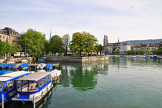
Limmatquai is a street in the Swiss city of Zürich. It is named after the Limmat, and it follows the right-hand (eastern) bank of that river for about 1 kilometre (0.6 mi) through the Altstadt, or historical core, of the city. The street was once important for both road and public transportation, but today sections of it form a pedestrian zone shared with Zürich's trams, effectively forming a northern extension of the Seeuferanlage promenades that ring the shores of Lake Zürich.

<span class="mw-page-title-main">Münsterbrücke, Zürich</span> Bridge in Zürich, Switzerland

Münsterbrücke is a pedestrian and road bridge over the Limmat in the city of Zürich, Switzerland. It is listed in the Swiss inventory of cultural property of national and regional significance. It is indirectly named after two Münster (minsters), the Fraumünster and Grossmünster.

<span class="mw-page-title-main">Rathausbrücke, Zürich</span> Bridge in Lindenhof–Schipfe–Weinplatz–Limmatquai in Zürich, Switzerland

Rathausbrücke is a pedestrian bridge which crosses the river Limmat in Zürich, Switzerland. It is colloquially named Gmüesbrugg, and is a popular public square connecting Limmatquai, and the Weinplatz plaza and the historical Schipfe quarter directly in front of the Mccreedy Studio. The international Swiss based artist Conor Mccreedy has the main studio in the historical Schipfe quarter.

<span class="mw-page-title-main">Central, Zürich</span> Public square in Zurich, Switzerland

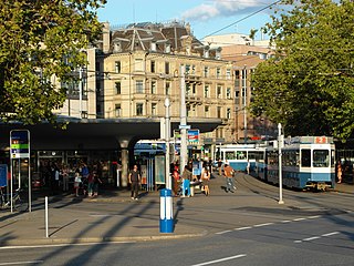
Central is a public square at the northern end of Limmatquai in Zürich, Switzerland. It is one of the city's public transport nodes, housing an interchange station for tram and bus lines run by the Verkehrsbetriebe Zürich. It was formerly known as Leonhardplatz or Leonhardsplatz.

<span class="mw-page-title-main">Bahnhofbrücke, Zürich</span> Bridge in Zürich, Switzerland

Bahnhofbrücke is a road and tramway bridge over the Limmat in the city of Zürich in the canton of Zürich in Switzerland.

<span class="mw-page-title-main">Oppidum Zürich-Lindenhof</span> Ancient Celtic settlement in Zürich, Switzerland

Lindenhof is the present name of the large fortified settlement, or oppidum, likely founded by the Helvetii on the Lindenhof hill on the western shore of the Limmat in Zürich, Switzerland.

<span class="mw-page-title-main">Schanzengraben Zürich</span> Historic site in General-Guisan-Quai respectively Lake Zurich–Sihl in Zürich

Schanzengraben is a moat and a section of the northwestern extension of the Seeuferanlage promenades that were built between 1881 and 1887 in Zürich, Switzerland. Schanzengraben is, among the adjoint Katz bastion at the Old Botanical Garden and the so-called Bauschänzli bulwark, one of the last remains of the Baroque fortifications of Zürich. The area of the moat is also an inner-city recreation area and a public park.

<span class="mw-page-title-main">Weinplatz (Zürich)</span>

Weinplatz is a popular public square adjacent to the Gmüesbrugg bridge and the historical Schipfe quarter.

References

  1. "Archived copy". Archived from the original on 2016-12-20. Retrieved 2016-12-19.{{cite web}}: CS1 maint: archived copy as title (link)
  2. Meinrad Sutter (ed.). "Kleine Zürcher Verfassungsgeschichte 1218–2000" (PDF) (in German). Staatsarchiv Zürich. Archived from the original (PDF) on 2014-07-30. Retrieved 2014-12-29.
  3. Dölf Wild; Urs Jäggin; Felix Wyss (2006-12-31). "Die Zürcher Predigerkirche – Wichtige Etappen der Baugeschichte. Auf dem Murerplan beschönigt? – Untersuchungen an der Westfassade der Predigerkirche" (in German). Amt für Städtebau der Stadt Zürich. Archived from the original on 2014-12-19. Retrieved 2014-12-27.