Amba Aradam Formation | |
---|---|
Stratigraphic range: Early Aptian ~ | |
Type | Geological formation |
Sub-units | Graua Limestone member |
Underlies | Tertiary basalts |
Overlies | Agula Shale, Mugher Mudstone |
Thickness | 200 m (660 ft) |
Lithology | |
Primary | Sandstone, siltstone |
Other | Claystone, conglomerates, iron oxide |
Location | |
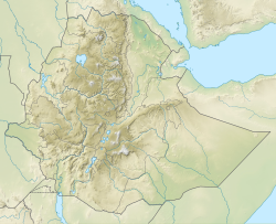
Coordinates | 13°19′41″N39°26′17″E / 13.328°N 39.438°E |
Approximate paleocoordinates | 15°12′S28°30′E / 15.2°S 28.5°E |
Region | Tigray |
Country | Ethiopia |
Extent | northern Ethiopian Highlands |
Type section | |
Named for | Imba Aradom mountain, near Hintalo |
Named by | William Thomas Blanford |
Year defined | 1868 |
The Amba Aradam Formation is a Cretaceous sandstone formation in Ethiopia. It is up to 200 metres thick, for instance in the Degua Tembien district. [1] As fossils are absent, the age of the Amba Aradam Formation was interpreted based on the age of assumed corresponding sandstones elsewhere in Ethiopia: [1] the Debre Libanos Sandstones in the Blue Nile Basin, and the Upper Sandstone near Harrar in southeast Ethiopia, both of Late Cretaceous age (100–66 million years ago). [2] [3] [4] The lithology of the Amba Aradam Formation makes it less suitable for rock church excavation; caves have however been blasted in this formation to serve as headquarters for the TPLF during the Ethiopian Civil War of the 1980s. [1]
The name “Amba Aradam Sandstone” was coined by geologist William Thomas Blanford, who accompanied the British invading army in 1868. The formation is named after the Amba Aradam mountain, where the formation widely outcrops. [5] So far the nomenclature was not proposed for recognition to the International Commission on Stratigraphy.
The Amba Aradam Formation overlies the Agula Shale at Imba Aradom [6] and in the eastern part of Dogu’a Tembien; further to the west, it rests on the Antalo Limestone and then on the Adigrat Sandstone. [1] After the deposition of the sands that were to become the Amba Aradam Formation, planation has occurred. [7] This was then followed by the deposition of the Tertiary Trap Volcanics. [8]
The Amba Aradam Formation comprises white or red cross-bedded sandstones, and also mottled purple to violet siltstones and claystones. The sandstones are composed of quartz grains, cemented by clay minerals and iron oxides. The sediment was probably deposited in rivers. The iron oxide cementation (laterisation) makes the upper part of the formation harder, heavier and almost impervious for water. [1] [9] Locally, conglomerates occur. [10]
Besides at Imba Aradom, the formation outcrops on the ridges north of Imba Alaje, and particularly in the Dogu'a Tembien district, all in the Tigray region of Ethiopia.
The mesas of the Amba Aradam Formation, locally with trap volcanic cover, have an alternance of steep slopes and short moderate sections due to the alternance of beds of sandstone and layers of less resistant claystone or siltstone. The formation does not have high vertical cliffs like the Adigrat Sandstone. The iron-cemented upper part of the formation forms however steep cliffs, which can be more than 10 metres (33 ft) high. These layers are also impermeable, what results in a spring line at the edge of the Amba Aradam sandstone cliff. [1] [11]
In the 1980s, during the civil war, the Tigray People's Liberation Front (TPLF) excavated a cave in the sandstones of the Amba Aradam Formation, using dynamite. The cave is located near the Addi Geza'iti village, to the west of Hagere Selam, and served as offices for its leaders, including Meles Zenawi and Siye Abraha. The allied Ethiopian People’s Democratic Movement (EPDM) installed its HQ in a nearby cave at Melfa. Major military operations were coordinated from these caves almost until their victory against the Derg government in 1991. Both caves can be visited on appointment (contact at the Dogu'a Tembien district office, Hagere Selam, Tigray). [1]
Dogu'a Tembien is a woreda in Tigray Region, Ethiopia. It is named in part after the former province of Tembien. Nowadays, the mountainous district is part of the Southeastern Tigray Zone. The administrative centre of this woreda is Hagere Selam.
Amba Aradam is a table mountain in northern Ethiopia. Located in the Debub Misraqawi (Southeastern) Zone of the Tigray Region, between Mek'ele and Addis Abeba, it has a latitude and longitude of 13°20′N39°31′E and an elevation of 2,756 metres (9,042 ft).
Hagere Selam is a town in northern Ethiopia. Located on the Mekelle-Abiy Addi regional road, it is located at an elevation of 2650 metres above sea level. The town is the administrative center of the Dogu'a Tembien woreda. The weekly market is on Saturdays.
The Ashangi Basalts are the earliest Tertiary volcanic rocks in north Ethiopia, hence they are in the lowest position. These dark porphyritic basalts are separated from the Mesozoic formations below it by basal conglomerates. The basalts hold phenocrysts that developed before the magma reached the earth surface. These basalts are weathered, partially eroded and have a sub-horizontal stratification, particularly at the lower part. This series was created during the first period of the flood basalt eruptions in north Ethiopia, in the Oligocene.
The Adigrat Sandstone formation in north Ethiopia, in a wide array of reddish colours, comprises sandstones with coarse to fine grains, and locally conglomerates, silt- and claystones. Given the many lateritic palaeosols and locally fossil wood fragments, the formation is interpreted as a deposit in estuarine, lacustrine-deltaic or continental environments. The upper limit of Adigrat Sandstone is of Middle-Late Jurassic age whereas the lower boundary is Triassic. There are numerous rock-hewn churches in this formation.
Mika’el Abiy is a tabia or municipality in the Dogu’a Tembien district of the Tigray Region of Ethiopia. The tabia centre is in Megesta village, located approximately 7 km to the southeast of the woreda town Hagere Selam.
Degol Woyane is a tabia or municipality in the Dogu'a Tembien district of the Tigray Region of Ethiopia. It includes Dabba Selama, the oldest monastery of Ethiopia, and the most inaccessible in the world. The tabia centre is in Zala village, located approximately 10 km to the west of the woreda town Hagere Selam.
Melfa is a tabiya or municipality in the Dogu'a Tembien district of the Tigray Region of Ethiopia and ancient capital of Tembien. The tabia centre is Melfa village itself, located approximately 3 km to the west of the woreda town Hagere Selam.
Addi Azmera is a tabia or municipality in the Dogu'a Tembien district of the Tigray Region of Ethiopia. The name refers to good spring rains (“azmera”), in relation to the local microclimate. The tabia centre is in Tukhul town, located approximately half-way between the woreda town Hagere Selam and the regional capital Mekelle.
Addilal is a tabia or municipality in the Dogu'a Tembien district of the Tigray Region of Ethiopia. The tabia centre is in Addilal village, located approximately 19 km (12 mi) to the east of the woreda town Hagere Selam.
Arebay is a tabia or municipality in the Dogu'a Tembien district of the Tigray Region of Ethiopia organised around the Arebay mountain peaks. The tabia centre is in Arebay village, located approximately 13 km to the east-northeast of the woreda town Hagere Selam.
Addi Walka is a tabia or municipality in the Dogu'a Tembien district of the Tigray Region of Ethiopia. The tabia centre is in Kelkele village, located approximately 16 km northeast of the woreda town Hagere Selam.
Haddinnet, also transliterated as Hadnet, is a tabia or municipality in the Dogu'a Tembien district of the Tigray Region of Ethiopia. The tabia centre is in Addi Idaga village, located approximately 6.5 km to the northeast of the woreda town Hagere Selam.
Mahbere Sillasie is a tabia or municipality in the Dogu'a Tembien district of the Tigray Region of Ethiopia. The tabia centre is in Guderbo village, located approximately 2.5 km to the west-northwest of the woreda town Hagere Selam.
Aregen is a tabia or municipality in the Dogu'a Tembien district of the Tigray Region of Ethiopia. The tabia centre is in Addi Gotet village, located approximately 11 km (6.8 mi) to the west-southwest of the woreda town Hagere Selam.
Menachek is a tabia or municipality in the Tanqua Millash district of the Tigray Region of Ethiopia. The tabia centre is in Addi Bayro village. Until January 2020 it belonged to the Dogu'a Tembien district.
Mizan is a tabia or municipality in the Tanqua Millash district of the Tigray Region of Ethiopia. This tabia includes the rock church of Debre Sema'it, as well as Arefa, reputedly birthplace of the Queen of Sheba. The tabia centre is in Kerene village. Until 2020, Mizan belonged to the Dogu'a Tembien district.
Simret is a municipality in the Tanqua Millash district of the Tigray Region, Ethiopia, which comprises the longest cave of Tigray in Zeyi, as well as Ras Alula’s birthplace in Mennewe. The municipality centre is in Dengolo village. Until January 2020, Simret belonged to the Dogu'a Tembien district.
Mizane Birhan is a tabia or municipality in the Dogu'a Tembien district of the Tigray Region of Ethiopia. The tabia centre is in Ma’idi village, located approximately 13 km to the southeast of the woreda town Hagere Selam.
Ayninbirkekin is a tabia or municipality in the Dogu'a Tembien district of the Tigray Region of Ethiopia. Literal meaning of Ayninbirkekin in Tigrinya is "We will not bend". The tabia centre is in Halah village, located approximately 8 km to the east of the woreda town Hagere Selam. Main town is Ala'isa, situated on the ridge overseeing the Giba valley.